KompSat-2 spacecraft consists of a payload-a multispectral camera and a satellite platform that takes it into space. The height of The KompSat-2 spacecraft is about 2.6 m with a diameter of 2.0 m in the withdrawal configuration. With the deployed solar panels and x-band antennas, the height and length are respectively about 2.8 and 6.9 m. the weight of the KompSat-2 spacecraft in the refueled state is about 800 kg.
Technical characteristics of the spacecraft KompSat-2
| Name of the spacecraft | KompSat-2 |
| Country | South Korea |
| Developer | KARI, Astrium |
| Operator | KARI |
| Launch vehicle | Rokot-KM |
| Launch date | 28.07.2006 |
|
Orbit: height, km inclination, degree circulation period, min time at the equator, hour |
Sunny-synchronous morning 685 98,1 98.5 10:50 |
|
Platform: Surveying equipment Angles of deflection, deg |
– MSC 50 |
| Period of active existence, years | 5 |
| Follow-up period, day | 3 |
| Power, W | 955 |
| The size of KA, m×m | 2.6×2.0 |
| The mass of SPACECRAFT, kg | 800 |
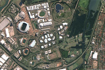
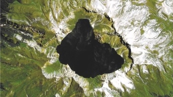
Kompsat-2 is designed to produce digital images of the earth's surface with a spatial resolution of 1 m in panchromatic mode and 4 m in multispectral mode. A distinctive feature of KOMPSAT-2 is a long continuous shooting time of up to 120,000 sq km (533 scenes) on a single turn. The satellite is also equipped with an onboard recording device capable of recording up to 15,000 sq km of survey.
Technical characteristics of onboard survey equipment
| Name of shooting equipment | MSC |
| Spectral ranges, microns |
Panchromatic (0.50-0.90) Blue (0.45-0.52) Green (0.52-0.60) Red (0.63-0.69) NIR (0.76-0.90) |
| Number of PAN elements, microns | 15000 |
| The number of elements of MS, microns | 3750 |
| Dynamic range, bit | 10 |
|
Terrain resolution PAN, m MS, м |
1 4 |
| Swath width, km | 15 |
| Memory capacity, Gbit | 64 и 96 |
| Data transfer rate, Mbit / sec | 320 |
Main cases of using data obtained from KompSat-2 spacecraft:
- creating and updating topographic maps and plans up to 1: 10,000 scale;
- creation of digital elevation models (DEM) of high accuracy;
- engineering surveys for the construction of infrastructure transportation and production of oil and gas;
- implementation of forest management works, inventory and assessment of forests;
- inventory of agricultural land, creation of land use plans;
- creation of city plans and schemes of territorial planning of municipal districts;
- inventory and monitoring of transport, energy and information communications;
- observations of natural disasters;
- control over the use of natural resources;
- conducting research in various fields.
For a preliminary calculation of the cost of covering the territory you need, space images from satellites KompSat-2 and alternative send the terms of reference or the coordinates of the site by e-mail: innoter@innoter.com we Will be glad to answer your questions by phone: +7 (495) 245-04-24