of geospatial solutions
Sat-Sun: Non-working days
- Annotation
- Technical and technological solutions for detecting and assessing forest fires on Planet Earth
- Aviation monitoring
- Registration and monitoring of fires from spacecraft
- Models based on UAV imagery
- Alerts, fire response - from remote sensing to firefighting
- Fire analytics
- Reforestation after fires
- Fire prevention system
- Fires in the Russian Federation
- Economic efficiency
Abstract
This article provides a review and analysis of remote monitoring and early warning methods for forest fires. Climate change is increasingly making its presence felt worldwide. In May 2023, wildfires were recorded on nearly 600 thousand hectares, and by mid-August, an area of 4 million hectares had been affected by fire. Various methods and techniques exist for the operational and, most importantly, timely extinguishing of forest fires. Based on recent research and technological developments, the authors highlight various approaches and innovative solutions used for the detection and monitoring of forest fires. The article examines methods that utilize modern observation tools such as satellites, unmanned aerial vehicles (drones), radar systems, and thermal imaging equipment. The final overview provides valuable information and recommendations for enhancing forest fire monitoring and warning systems using remote technologies.
1. Technical and Technological Solutions for Detecting and Assessing Forest Fires on Planet Earth
1.1 Aviation Monitoring
Currently, developed countries worldwide use various types of aircraft carriers equipped with imaging systems for remote monitoring purposes.
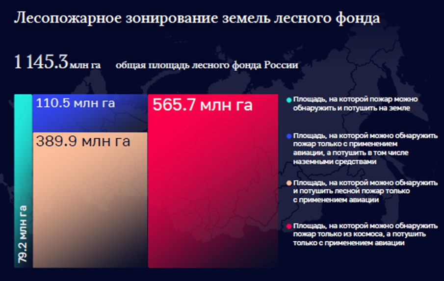
The distribution of forest land by monitoring methods (Order of Rosleskhoz No. 290 of July 09, 2009, "On the Distribution of Forest Land by Methods of Monitoring Fire Hazard in Forests and Areas for Aviation Forest Protection") is presented in Fig. 1.
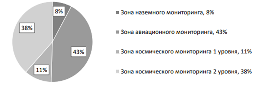
Fig. 1 Diagram of the distribution of forest land by monitoring methods
Aviation monitoring covers inaccessible areas with an area of 489.4 million hectares (42.7% of forest land territories). Flights are impossible in adverse weather conditions such as strong winds, storms, fog, and low cloud cover. Smoky terrain poses a hindrance to patrolling, and difficulties arise when patrolling mountainous landscapes. Monitoring from aircraft covers a relatively small area; the speeds of planes and helicopters currently used in patrolling are not excessively high. Visual identification of the fire area and its boundaries may lead to significant inaccuracies, and hidden fire sources without visible smoke remain undetected.
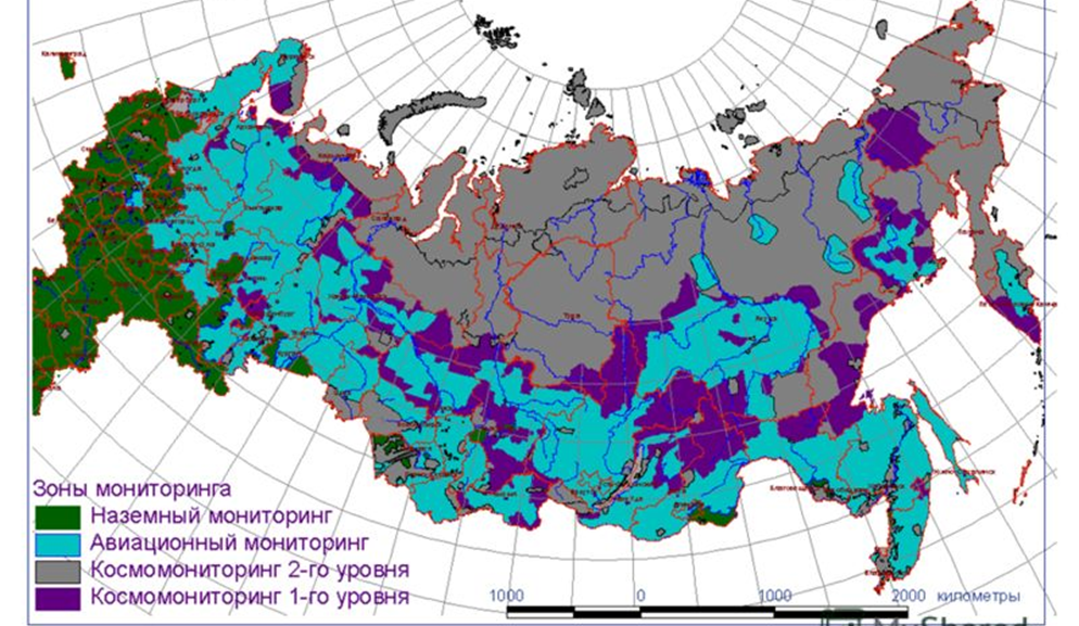
Fig. 2 Zoning of forest land territories by monitoring methods
More than 300 aircraft are involved in aviation forest patrols in Russia every year. However, it is essential to note that the key drawback of the aviation patrol method is the significant cost per flight hour. For example, the flight hour of an An-2 aircraft costs from 40,000 rubles. However, this aircraft has long been out of production, and dozens of planes are written off every year. Therefore, forest protection organizations are forced to replace the An-2 with modified versions of the Mi-8 helicopter, with a flight hour cost exceeding 130,000 rubles.
There is hope for the revival of small aviation in the form of a new light multipurpose aircraft "Baikal" (LMS-901). In 2022, the first test flights took place, and it is planned to put 154 new aircraft into operation by 2030. Their technical characteristics are significantly higher than the outdated An-2, and the cost per flight hour will be around 60,000 rubles.
It is worth noting that specialized personnel are required for aviation monitoring, including navigators who determine the flight route, visually detect fire zones, and determine the coordinates of the fire, as well as pilots capable of operating an aircraft in conditions of high smokiness and, consequently, low visibility. Continuous aerial monitoring of a large area is also impossible, which can lead to late detection of a fire.
1.2 Registration and Monitoring of Fires from Satellites
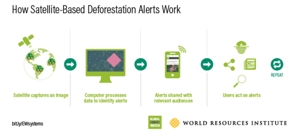
The global remote sensing community has relatively well-established fire registration through satellite observations. There are five accessible portals (NASA, ESA, Global Forest Watch, Global Wildfire Information System (GWIS), CTIF - The International Association of Fire & Rescue Services), and the Global Fire Monitoring Center (GFMC) that provide data on fires worldwide.
Mapping fires is the primary mode of representation. Typically, mapping of forest fires is based on satellites like TERRA (MODIS), LANDSAT, SENTINEL, and PLANET. Subsequently, statistical and phenomenological analysis is conducted. Interactive diagrams and maps summarize key statistical data, such as information about forests in Russia. Statistical data includes forest change rates, forest area, deforestation factors, as well as warnings about deforestation and fires. It also includes data on regions with the highest number of fire alerts and a comparison of current fires with historical trends.
Satellite remote sensing is currently capable of: creating models for climate and hydrological applications based on images (pre-fire); detecting forest fires based on vegetation (pre-fire); actively monitoring fires (during the fire); smoke modeling and forecasting; Earth system modeling for climate and hydrological applications (post-fire); detecting forest fires based on vegetation data (post-fire).
Previous satellite experiments - the FireBIRD mission conducted by the German Aerospace Center (Deutsches Zentrum für Luft- und Raumfahrt; DLR), a pair of satellites — TET-1 (technology experiments carrier) and BIROS (bistable infrared optical system) confirmed the capabilities mentioned above.
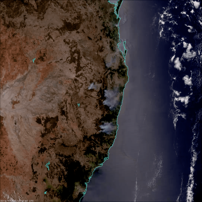
Fig. 3 Satellite images of fires in Australia
Satellite remote sensing can confidently detect forest fires in areas ranging from 10–15 hectares when the fire area is not covered by clouds. The main task of satellite forest fire monitoring is to provide forest management authorities in the subjects of the Russian Federation with operational information on the forest fire situation.
Additionally, there is a significant issue with obtaining cloud-free data, as high-quality images with high spatial resolution can only be obtained when cloud cover is no more than 15%.
Forest land, where satellite monitoring of forest fires is carried out, is divided into two levels:
- 1st level – remote areas (11% of forest land), where planned aviation patrolling is not carried out, and ground and aviation zones are not allocated. Extinguishing forest fires can be done using aviation forces and means. Patrol flights are recommended for areas with high fire hazard levels across the entire protected territory;
- 2nd level – remote and hard-to-reach areas (38.5% of forest land), where aviation patrolling is not carried out, and extinguishing forest fires is only done when there is a clear threat to settlements or economic facilities. The main method of detecting forest fires is the data from the ISDM–Rosleskhoz.
The Information System for Remote Monitoring (ISDM) of forest fires by Rosleskhoz successfully uses data from remote sensing with spatial resolutions ranging from 250 meters to 1000 meters in the thermal IR range (data from satellites such as Terra, Aqua, Noaa, Suomi NPP, Meteor M).
Fires can be tracked on a large scale from satellite remote sensing. However, the response time is from 2 to 10 days. Monthly fire maps from NASA show active fire locations worldwide based on observations from the Moderate Resolution Imaging Spectroradiometer (MODIS) on NASA's Terra satellite Terra. The targeted MODIS equipment on Terra and Aqua satellites allows capturing images with a spatial resolution of 250–500 m/pixel, in the spectral range of 3,660–14,385 µm (16 different channels), with a swath width of 2300 km. Imaging repetition for a specific area is four times a day, and the imaging equipment's productivity reaches up to 700,000 km2 per day.
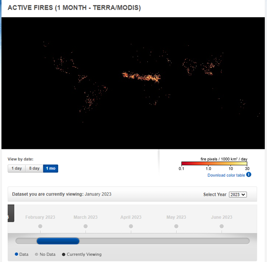
Figure 4
The colors are based on the count of fires (not size) observed in an area of 1000 square kilometers. White pixels indicate the upper limit of the count — up to 30 fires in the area of 1000 square kilometers per day. Orange pixels show up to 10 ignitions, and red areas represent only 1 ignition per day.
Some global patterns that emerge on fire maps over time are the result of natural cycles of rain, drought, and lightning. For example, natural fires often occur in the boreal forests of Canada during the summer. In other parts of the world, patterns result from human activity. For instance, intense burning in the heart of South America from August to October is the result of human-caused fires, both intentional and accidental, in the tropical forests of the Amazon and the Cerrado (a pasture/savannah ecosystem) to the south. Across Africa, a belt of widespread agricultural fires sweeps from north to south across the continent as the dry season sets in each year. Agricultural burnings occur annually in late winter and early spring in Southeast Asia.
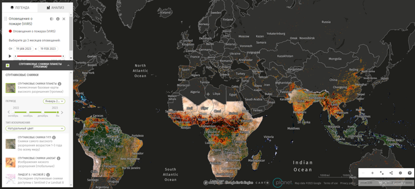
Figure 5
Algorithms have been developed that approximate the results by sampling the selected area. Results are more accurate at closer levels of scaling and are complemented by current results from UAVs in multispectral, hyperspectral, and lidar ranges.
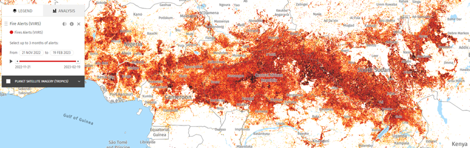
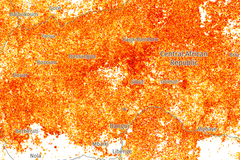
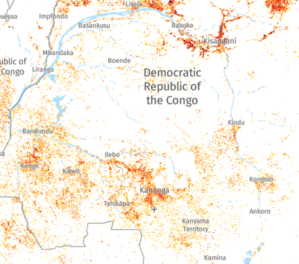
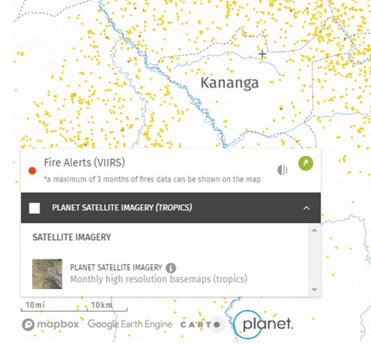
Figure 6 As of February 20, 2023
An automatic forest fire detection system has been developed using data from NOAA meteorological satellites. The system has been tested in four pilot experiments in Finland and neighboring countries, including Estonia, Latvia, Russian Karelia, Sweden, and Norway. For each detected fire, a message with data about the ignition location, observation time, and a map indicating the location is sent directly to local fire authorities. The smallest detected forest fires covered an area of 0.1 hectares. The average time delay between receiving the NOAA scene and sending the fire alert was 31 minutes. Almost all detected fires were forest fires or prescribed burns. In a pilot experiment in the summer of 1997, 363 fires were recorded and warned. The verification showed that 83% of the issued warnings related to real fires. According to authorities, none of the genuinely significant forest fires, for example, in Finland, went unnoticed. The good results of the check show that the satellite forest fire detection system is reliable, fast, economical, and has potential in sparsely populated areas if continuous delivery of mid-infrared satellite data can be guaranteed in the future.
The domestic Information System for Remote Monitoring (ISDM) of forest fires by Rosleskhoz successfully uses data from remote sensing with spatial resolutions ranging from 250 meters to 1000 meters in the thermal IR range (data from satellites such as Terra, Aqua, Noaa, Suomi NPP, Meteor M).
The developed unified space information processing system designed for mapping forest fires and burns is regularly used in the European (Planet Research Center, Moscow), West Siberian (Novosibirsk), and Far Eastern (Khabarovsk) centers of Roshydromet.
To refine "burned" areas in automatic mode, materials from remote sensing with a spatial resolution of 250 meters are used (data from satellites such as Terra and Aqua); with the participation of the operator, materials from remote sensing with a spatial resolution of 10-30 meters in the visible spectral range (data from satellites such as Landsat-7, Landsat-8, Sentinel-2, Kanopus-V, Resource-P). Thus, the entire forest fund is covered by remote sensing. High spatial resolution images should cover the entire area "passed" by the fire for further detailed interactive visual analysis of forest fires, smoke, and burning dynamics.
Figure 7 Information on the use of space remote sensing materials in the Rosleskhoz Remote Monitoring Information System (ISDM-Rosleskhoz)
The processed results obtained daily are regularly transmitted to Russian fire services. The ISDM has at its disposal aviation assets (Avialesookhrana units) to work with space information and carry out observation and firefighting measures.
For monitoring the occurrence and spread of fires, various methods are used. Fire detection is based on the detection of an increase in local temperature and brightness on the ground. Detecting fires in satellite images is possible due to the temperature difference between the Earth's surface and the fire source, which, in turn, leads to a difference in the thermal radiation of fire objects by orders of magnitude. In visual fire detection, identification is based on the presence of a burning source in the field of view, such as a smoke plume.
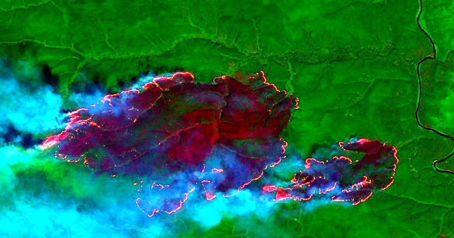
Figure 8 Fragments of synthesized multispectral images from the "Sentinel-2 L1C" satellite dated July 31, 2019, Evenki district of Krasnoyarsk Krai
Aerial photography from an airplane or helicopter has undeniable advantages over space-based methods since the user determines the time (schedule) of flights, the configuration of the surveyed area (flight path direction), acceptable weather conditions. These shots are characterized by higher spatial resolution, immediacy, high mobility in choosing the object and shooting parameters, and no cloud influence (sub-cloud shooting).
As disadvantages of satellite monitoring, it is necessary to note the large area of the minimum detectable ignition source, ranging from 0.2 to 0.5 km2 when analyzing high-resolution images, low data acquisition frequency (several times a day), and strong influence of weather conditions.
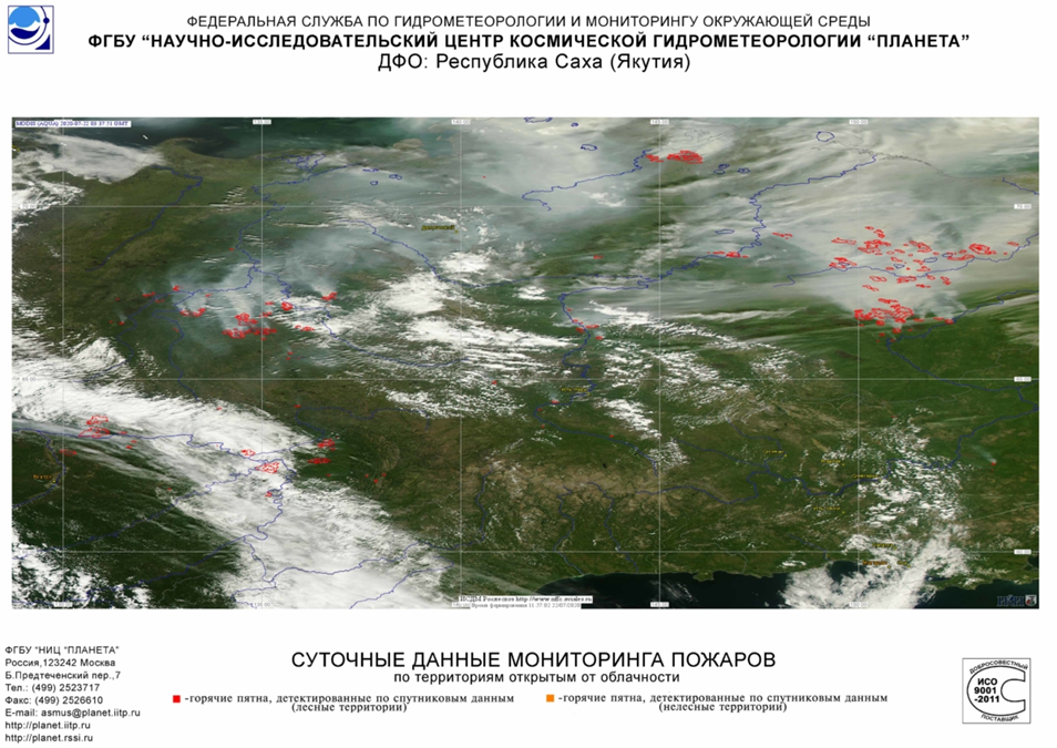
Figure 9 Fire monitoring data presented by the Federal Center for Integrated Arctic Research of the Russian Academy of Sciences (FCIARctic)
Domestic satellites RESURS, KANOPUS with imaging equipment MSU-E, MSU-SK allow obtaining images with a spatial resolution of 90 cm/pixel in the spectral range of 0.5–1.01 μm. The satellite's pass frequency over the same point on the Earth's surface is called the shooting frequency, and for the RESURS satellite, it is 6 times a day. Despite all the drawbacks, satellite monitoring is necessary for large forested areas and when monitoring by other means is not possible (the cost of satellite monitoring is also relatively low). Information obtained from satellite imagery is essential for monitoring large fires and assessing their consequences.
1.4 Models based on UAV Images
The use of unmanned aerial vehicles (UAVs) in extinguishing forest fires allows for effectively surveying the entire fire area and adjacent territories to coordinate the work of firefighting services. The direction of fire development is well visible from above. Data obtained from UAVs helps determine the directions in which it should be extinguished to localize the outbreak in the shortest possible time.
A thermal imager installed on a UAV allows detecting ignition sources at the very early stages when the fire is impossible to see with the naked eye.
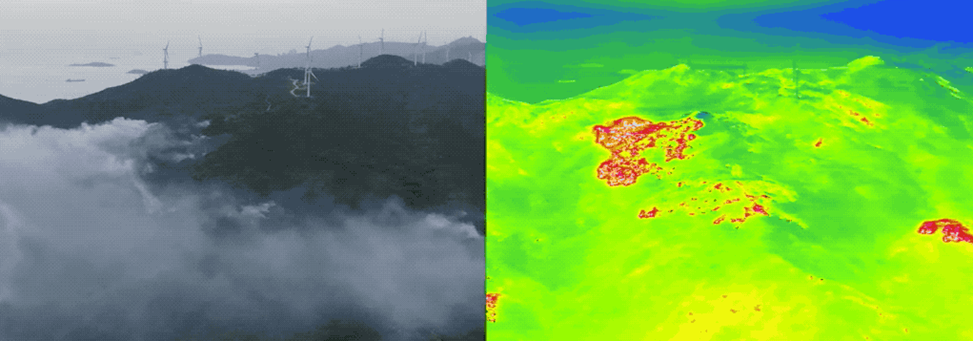
Figure 10 Joint imaging with a UAV in visible and thermal IR ranges
The application of UAVs for monitoring forest fires has the following advantages:
- UAVs can take off from any geographic point. They do not require the use of an aerodrome or landing pad;
- pre-flight preparation takes a few minutes;
- the use of UAVs is significantly cheaper than using airplanes and helicopters.
Models based on UAV images are recommended for detecting forest fires due to high mobility and provide coverage at different altitudes and locations with low costs. Therefore, an effective and scalable UAV is used for detection. For example, the model used NetImage classifier, a neural network, and machine learning, which is a combination of Yolov5 and EfficientDet. The dataset used includes 10,581 images, of which 2,976 images belong to the category of forest fires and 7,605 images without fires. The model undergoes a reasonable training process, and an accuracy of 99.6% was achieved on 476 fire images. For 676 images resembling fire images, the achieved accuracy was 99.7%. However, the limitation is that it does not detect smoke, as it is necessary at the initial stage of the detection process. This model is aimed at developing a 3D model of the captured scene. The YOLOv5 network is deployed to detect fire. The detection speed accuracy achieved with this model is 91%. The proposed model outperforms other existing methods in terms of early-stage detection. However, this model is sensitive to forests with dense fog and clouds. This is because smoke looks the same as fog, and the model may mistakenly classify fog as smoke. In addition, the network has a range of 5-10 km.
It is clear that various methods of statistical analysis and modeling are used to obtain new information about forest fires that can be used to improve the interaction between fire, people, and ecosystems.
Currently, UAVs are becoming increasingly popular in wildfire management systems due to their key characteristics such as maneuverability, autonomy, ease of deployment, and low cost. UAVs with remote sensing capabilities are used with artificial intelligence, machine learning, and deep learning algorithms to detect ignition areas, forecast, make decisions, and optimize fire monitoring tasks. In addition, drones equipped with various advanced sensors (sensors), including lidars, visual, infrared (IR), and monocular cameras, have been used to observe forest fires due to their potential to provide new approaches and opportunities for research.
Alerts, Response to Fires - From Detection to Firefighting
Various fire detection systems have been created; here are some examples:
- For instance, alerts are based on data from the European Space Agency's Sentinel-2 satellites with a resolution of 10 meters, making them the highest-resolution alert system. GLAD and GLAD-S have proven their effectiveness in the Amazon forests. The GLAD-S2 system offers much more detail than GLAD alerts based on Landsat: 6.25 pixels of GLAD-S2 alerts fit into one GLAD pixel.
Since the goal of alert systems is to detect changes as quickly as possible to encourage action, reducing the delay from deforestation to detection is crucial. This allows for even faster response to illegal or unwanted activities, ideally preventing further deforestation.
Early warning systems provide regular updates on recently changed areas in forests, leveraging satellites like Landsat and MODIS, which often provide free Earth images. Most systems use artificial intelligence methods that can automatically detect deforestation and other disruptions on these images by "looking for" a sharp decrease in greenery in the image, i.e., fires. These algorithms are sometimes run in parallel processing mechanisms, also known as cloud computing, enabling the analysis of large areas on a continuous basis.
RADD alerts - Radar for Deforestation Detection (RADD) is now also being built for responding to fire incidents based on publicly available radar data from the European Space Agency's Sentinel-1 satellites.
Fire areas detected by satellites are now registered in Europe through processing centers on smartphones for foresters and firefighting services. Civil Protection.
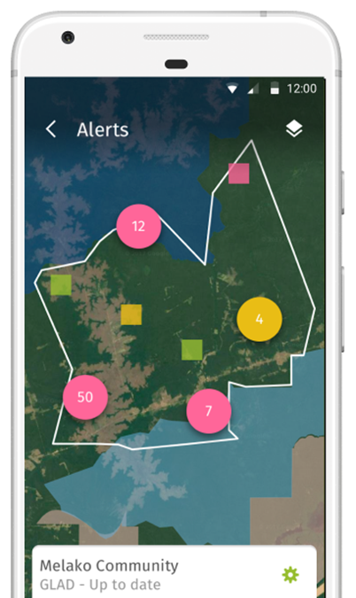
- Foresters patrolling their forest areas can now use a mobile app, such as "Forest Watcher," allowing for dynamic online forest monitoring and Global Forest Watch alert systems in offline mode and field conditions. They can track their areas of interest, view deforestation and fire alerts, navigate to points for investigating suspicious fire locations, and gather information as they typically do, regardless of web technology connectivity.
- The UraFire system aims to reduce the number of false alarms by detecting smoke based on two input data: motion clusters and temporal input. The UraFire system is used and produced in France.
- Forest Fire Finder is a complex system based on atmospheric analysis rather than fire glow or smoke column detection. Forest Fire Finder tracks how the atmosphere absorbs sunlight. Naturally, absorption depends on the chemical molecules or composition of the atmosphere. Different compositions have different absorption behaviors; thus, Forest Fire Finder can identify different types of smoke depending on the source within a radius of 15 km, for example, organic smoke from burned trees and industrial smoke. The equipment is installed in the treetops for faster detection, and this system is used in Portuguese forests.
- The most popular forest fire detection system is ForestWatch. However, only Canada has documented its own experience with this system. Canada reported that fires were reliably detected at a distance of 20 km, but a large number of false alarm signals were also generated. Active ForestWatch systems are used in the USA (22 towers), Canada (4 towers), South Africa (83 towers), Chile (20 towers), Eswatini (5 towers), and Slovakia (4 towers). A pilot installation (2 towers) is set up in Greece. The tower scans the forest within a radius of 16-20 km for smoke columns during the day and fire glow at night.
- The problem of direct visibility of optical cameras in the forest can be solved with second-type sensors. A new technology called Wireless Sensor Network (WSN) can be deployed in a large number of systems, one of its potential applications being forest fire detection. WSN is based on a Wireless Sensor Network (WSN), nodes of which measure the surrounding environment for early detection and prevention of forest fires in rural areas. WSN is built using open-access technologies and uses the Zigbee standard for radio frequency communication between nodes. The measured data collected by WSN are sent to a web server using General Packet Radio Service (GPRS) over the TCP/IP protocol. Two metrics are used to assess the performance of WSN: data transmission rate and time delay, measured from the data collection to receiving them on the web server. WSN demonstrates an average successful data transmission rate of over 86% and an average time delay of less than 500 milliseconds in all conducted tests, demonstrating the potential of WSN as a real-time forest fire detection system.
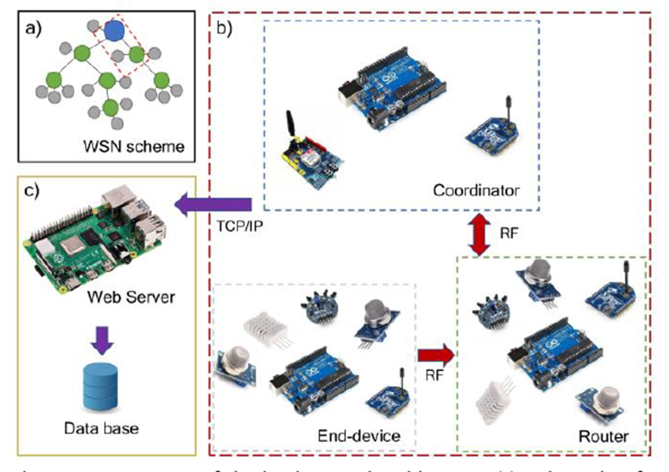
Components of the implemented architecture. (a) Diagram of the tree-like topology of WSN. (b) End devices and router nodes include sensors and XBee modules for measuring and sending data, while the coordinator node includes only XBee and GPRS modules for internal and external communication with the server. (c) Web server hosted on the embedded Raspberry Pi system. The server controls the reception and storage of data coming from WSN.
Naturally, the combination of fieldwork, automatic ground sensors, UAVs, and satellites can help reduce the response time to forest fires.
For example, in the United States, various technical options for fire detection are maximally utilized. As early as 2018, the U.S. Forest Service reported that a crucial first step in combating forest fires is improving the current outdated fire detection infrastructure.
FireWatch is a camera-based device that uses computer vision for the automatic identification of wildfires and provides rapid response services with the precise latitude and longitude of the fire. FireWatch aims to eliminate current failures in existing fire detection systems by providing reliable and accurate fire detection at a cost of only $110, a significant improvement compared to existing systems. One of the most significant achievements in the FireWatch system is its ability to convert pixel coordinates of the fire into real latitude and longitude. This is done using the FireWatch localization mechanism. The mechanism can match an image captured by one of the FireWatch devices with the visualization of the same location in Google Earth, and then use ray tracing to find the intersection of the Google Earth image and the FireWatch camera image. This system allows FireWatch to locate the exact position of the fire within ±50 meters. Currently, the first FireWatch devices are deployed in the Shenandoah Mountains near the border of Virginia and West Virginia. These devices actively monitor over 500,000 acres of land and have detected more than a dozen fires by 2020 in the region. Currently, in collaboration with local partners, FireWatch is building infrastructure in the Everglades in Florida, the Sierra Nevada in California, and the Rocky Mountains in Colorado.
Fire Analytics
The lack of reliable descriptive analytics on the effectiveness of responding to forest fires is a bottleneck in the development of operational and empirically credible predictive and prescriptive analytical data to inform and guide strategic response decisions. The use of technologies such as automated resource tracking and machine learning algorithms can help bridge the gap between monitoring, training, and data-driven decision-making.
A combined platform is used to visualize trends in data, information on fire locations, and future fire risks. Such a tool not only provides an excellent platform for creating fire situation reports and monitoring information panels but also helps perform the following analytical tasks:
- Trend analysis.
- Hotspot analysis.
- Distribution.
- Geospatial clustering.
- Alerts / Subscription.
- Geographic routing/distance calculation.
- Segmentation/Correlation.
To enhance the analysis, this information panel also tightly integrates data into user-created GIS - ArcGIS and 3D scenes. This allows GIS administrators to provide additional context for areas of interest.
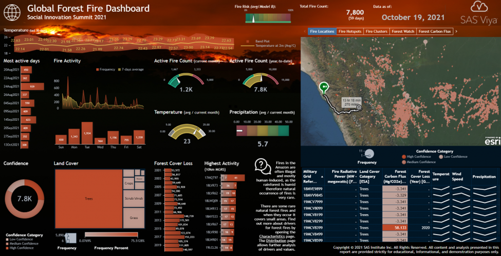
The above figure, for example, shows a report page describing the current state of active fires (current count, year-to-date), as well as fire hotspots and their locations on the map. Researchers can interact with the information panel and filter by specific dates or geographical locations of interest. The KPI indicator at the top also shows the current overall fire occurrence risk determined by the analytical model.
Users can also perform specific clustering and segmentation using the built-in cluster analysis tool, selecting relevant risk factors and exploring fire locations with corresponding cluster information on the geographical map. In the example below, the system identified three different clusters considering the "Carbon Flow in the Forest," "Distance to Roads," and "Altitude Above Sea Level" indicators. As a result, the cluster represents fire locations with low or negative CO2 emissions, a location close to the road, and different altitude levels. On the geographical map on the right, all fire locations are shown colored with the corresponding cluster identifier.
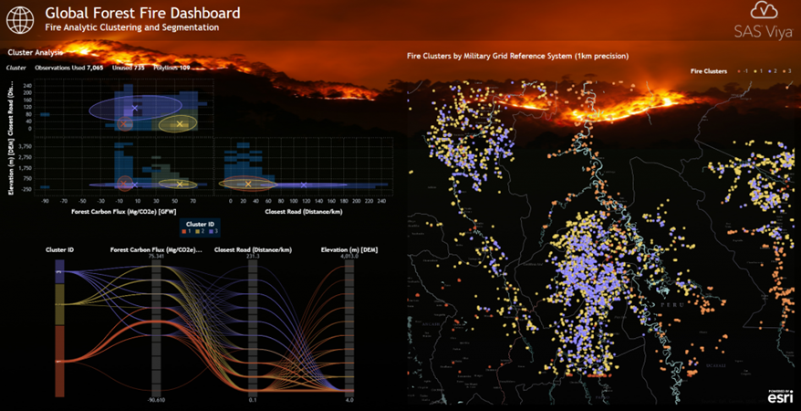
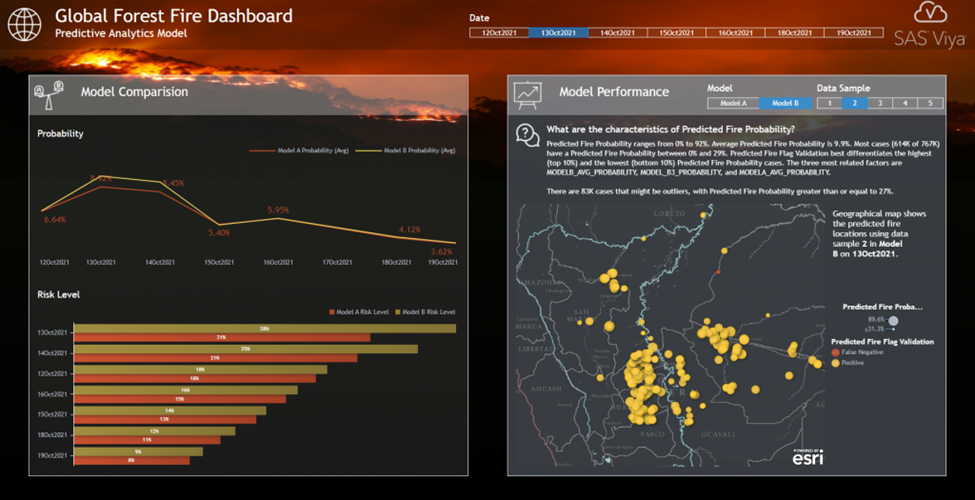
Given such an analytical model, this toolbar page now compares both actual fire data and predicted fire locations. This allows a detailed comparison of the performance of each individual model and identifies potential areas of interest. Predicted fire locations are color-coded with the corresponding checkmark flag: correctly predicted locations (true positives) are shown in yellow, and locations that the model predicted incorrectly (false negatives/positives) are shown in red.
Modeling the probability of ignition and subsequent forest fire activity suggests using the behavior of cascading forest fires in a forest fire simulator in forest network graphs. A linear threshold model is used along with various mathematical models that "define" the behavior of fire spread. Then, a fire prevention strategy is proposed to reduce the damage from forest fires. The edge removal algorithm in forest networks can reduce the impact of forest fires by up to 85% compared to no preventive measures.
The modeling process includes using random forest models, gradient boosting, logistic regression, and neural networks. Fully automated, for example, in the Model Manager, the system selected Random Forest as the main model, providing the most accurate forecast of the risk of fire occurrence.
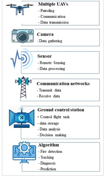
Figure 11 Components of the forest fire management system based on UAVs
Forest Restoration After Fires
Prescribed burning, improved technical infrastructure maintenance, increased awareness and training on fire prevention, as well as policy measures such as fire bans, can reduce the risk of forest fires. Protecting forests from deforestation and degradation also enhances their resilience to fires.
One of the first measures that most foresters plan after a fire is forest restoration immediately post-fire. Forest restoration is the process of establishing a new stand of trees on a forest site after a disturbance, such as a fire. There are two ways to restore a forest. Natural regeneration is when you let nature take care of the job of planting trees in an area, while artificial regeneration is when you plant the area yourself. The success of any natural regeneration after a burn depends on the abundance of seeds available in surviving species and in soil seed banks that remain after the fire. While this is the most economically efficient means of forest restoration, it does not allow for the selection of species, stocking levels, and tree spacing.
Planning for restoration is often based on the development of geospatial maps and plans (orthophotos) created via UAVs on the forest site.
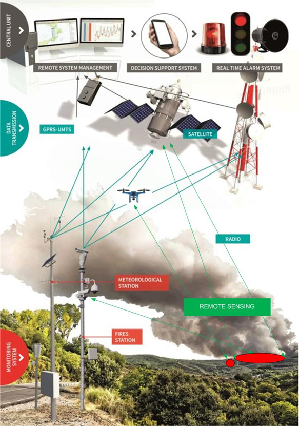
Fire Warning System
To accomplish all this, the system takes into account several variables, including: tracked weather data, geographical landscape location; ground conditions; quantity, distribution, and type of buildings on the monitored area; the number of people residing in each building, village house; images from satellites, UAVs, ground-based thermal and video cameras with panoramic system and panning, with day and night optical, IR elements, and dome cameras that can be controlled remotely. All gathered information is utilized to support fire management and combat, declare a state of readiness, implement bans and safety measures for the population, plan controlled fires or other events related to handling flammable substances, and prevent major fires.
The key factor in fire detection is time.
Unfortunately, in many countries worldwide, there is still no fully developed early fire warning system capable of preventing large-scale annual fires.
We need to manage fires differently, use analytics to predict where on the landscape we can create controlled fires of the right size within predetermined boundaries.
When creating a system, one cannot separate the social from the technical. Approaches to risk management and fire data analysis are also linked to a cultural shift. If tomorrow we can track every firefighter and check the effectiveness of fire suppression, it will not change anything. Officials need to value the role of data-driven decision-making and hold others accountable for it.
For instance, an attempt to create a system under the DISARM project (Drought and Fire Observatory and Early Warning System), within which an early warning system for forest fires in the Eastern Mediterranean was developed.
The monitoring and early warning system for forest fires are based on multi-sensor and multi-level data integration technology.
The four pillars of this system include:
- forecasting the danger of forest fires,
- detection of forest fires using remote sensing methods,
- prediction of the spread of forest fires using a linked weather and fire modeling system,
- assessment of the risk of forest fires within the framework of climate change. Special attention is paid to innovative and reproducible parts of the system.
The infrastructure is based on the MHAS (Multi-Hazard System) platform, a comprehensive and advanced tool for protection against many hazards. This system can:
- prevent fires by calculating fire risk indicators;
- spot fires through continuous visual observation of the area and the use of high-magnification cameras that can also be controlled remotely;
- early detection of the fire ignition point;
- manage emergency fire extinguishing operations by integrating models that allow displaying the possible spread of fire on maps with geographic linkage.
The system identifies some shortcomings in the EUMETSAT (European Organization for the Exploitation of Meteorological Satellites) and LSA-SAF (Land Surface Analysis Satellite Application Facility) algorithms in their ability to detect forest fires over islands and near the coastline.
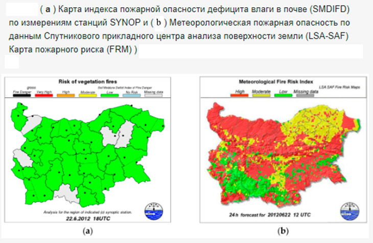
Regional authorities could benefit directly from the DISARM system when developing/programming preparatory actions. With the system, civil protection authorities and fire services will enhance their capabilities in combating forest fires. Stakeholders from the public and private sectors will benefit from DISARM by using an interactive mobile application. Such an approach provides citizens with useful information and actively involves them in the information generation process.
The technical equipment for such a system could be presented in the diagram below, with the addition of IoT field sensors.
Forest Fires in Russia
According to world statistics, Russia holds the first place in the world in terms of forest fires.
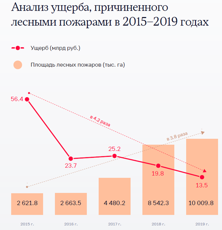
According to the analysis of the Accounts Chamber of Russia, "The situation with forest fires in our country remains complex. Every year, the area of forests affected by fire amounts to millions of hectares, and the damage from forest fires is billions of rubles (in 2019, more than 13 billion rubles). The number of forest fires exceeds 10 thousand cases annually.
An analysis of the situation with forest fires over a five-year period (from 2015 to 2019) showed that the number of forest fires increased by 20.1% to 13,602 cases, their area increased 3.8 times to 10,009.8 thousand hectares. The damage from forest fires in 2015-2019 ranges from 13.5 to 56.4 billion rubles with a decreasing trend by 2019.
In particular, there is a lack of a systematic approach to the formation and monitoring of the implementation of the federal project "Preservation of Forests" in the context of regions, indicating the absence of such a system in Russia.
Recommendations from the Accounts Chamber:
- Develop criteria defining the inaccessibility and remoteness of territories to establish fire control zones, as well as the methodology for determining;
- Forecast the expected costs of extinguishing a forest fire and develop a methodology for determining the predicted damage that forest fires can cause in the control zone;
- Develop a methodology for calculating the damage caused by forest fires.
These measures are directly related to the activities of remote sensing, considering the scale of our forested territory.
Implementation of fire safety measures in forests (Article 53 of the Forest Code):
- Preventing forest fires;
- Monitoring fire hazards in forests and forest fires;
- Developing and approving plans for extinguishing forest fires;
- Other fire safety measures in forests (construction, reconstruction, and operation of forest roads designed to protect forests from fires, landing sites for aircraft, helicopters used for aviation work to protect and defend forests, fire observation posts, concentration points for firefighting equipment;);
- Clearing firebreaks, fire lanes, and the creation of fire mineralized strips;
- Construction of fire ponds and access roads to sources of fire water supply.
By Order No. 167 on the technical equipment of firefighting organizations, for example, satellite navigation devices (navigator), monitoring systems with unmanned aerial vehicles, and (or) unmanned aviation systems are not included at all.
The conclusion of the Accounts Chamber of Russia: "The solution to the problem of forest fires requires a comprehensive approach."
There is no mention of creating a modern online detection and rapid response system for extinguishing, with the necessary resources and means.
Economic Efficiency
During the period from 2021 to 2022, forest fires caused damage, for example, in the United States, amounting to over 11.2 billion dollars. In Russia, for the period 2015–2019, it was 138.6 billion rubles.
Not to mention the human casualties, the cost of a forest fire mainly depends on three components:
- The cost of material damage (buildings, rural houses, power or telecommunication lines, road or railway infrastructure, etc.),
- The cost of certain medium- and long-term consequences of fires for the environment, forest lands, fields, agricultural lands, and ecological damage (15-20% of all greenhouse gas emissions come from forest fires),
- The cost of firefighting itself.
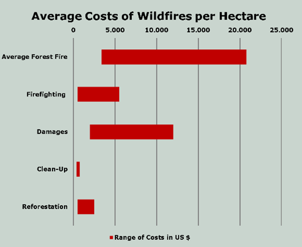
On average, forest fires worldwide "burn" about 3400–17,400 US dollars per hectare. The cost of firefighting ranges from 500 to 5000 US dollars per hectare. The damage is estimated from 10,000 US dollars to tens of billions depending on the type of forest and its value. Post-fire cleanup operations are estimated at 400 US dollars per hectare, while reforestation efforts can cost from 500 to 2000 US dollars per hectare. The costs of the system will not exceed 25% of the losses due to fires. (Source: Hannover Rück). For example, in California, the damage from forest fires and destruction in just 2017 was estimated at 15 billion US dollars.
Due to the exponential growth of forest fires, early fire detection is crucial to limit fire damage. Currently, modern standalone forest fire detection devices can cost over 70,000 dollars and still cannot provide emergency services with the exact location of the fire. But the problem requires a solution.
Top Fire Monitoring Services Worldwide
4.1. Global Forest Watch (https://www.globalforestwatch.org/): Global Forest Watch is an online platform developed by the World Resources Institute in collaboration with other organizations. It provides an interactive map view of global forest fires and other aspects of the forest's condition. The site allows you to track current fires, view historical fire data, receive notifications, and access analysis tools to study the real-time forest situation. Global Forest Watch also provides a wealth of other data, including information on forest resources, projects, and research.
4.2. European Forest Fire Information System (EFFIS) (https://effis.jrc.ec.europa.eu/): EFFIS, developed by the Joint Research Centre of the European Commission, provides information on forest fires and fire danger in the European Union countries and neighboring regions. Their website features interactive maps displaying current fires, the location of fire stations, resources, and fire risk data. EFFIS also offers reports and analysis tools for assessing forest fire risk and planning forest management.
4.3. National Interagency Fire Center (NIFC) (https://www.nifc.gov/): The National Interagency Fire Center (NIFC) is an organization in the United States responsible for coordinating the efforts of all state and federal agencies involved in preventing and controlling forest fires. On their website, you can find information about current fires, resources, and operational activities, including logistical support and coordination of firefighting crews. NIFC also provides access to other resources such as useful links, educational materials, and statistics on forest fires in the United States.
4.4. NASA Fire Information System (https://earthdata.nasa.gov/earth-observation-data/near-real-time/firms): NASA Fire Information System, provided by the National Aeronautics and Space Administration (NASA), uses data collected by various satellites and sensors to detect and track forest fires worldwide. On their website, you can access maps and analysis tools to study fires and analyze data such as fire area, intensity, and distribution. NASA Fire Information System also provides information on fire activity and statistics for various time periods.
4.5. Federal State-Funded Institution "Avialesookhrana" (https://public.aviales.ru/mapviewer/cgi/): Avialesookhrana is a federal state-funded institution in Russia responsible for forest fire protection. They have a dedicated website for monitoring forest fires, helping to track the situation and prevent the spread of fires.
The Avialesookhrana forest fire monitoring website provides up-to-date information on the current fire situation in various regions of Russia. The site features an interactive map displaying data on fire localization and suppression, as well as overview reports on the fire situation in different regions.
In addition, the site presents statistics on the number of registered forest fires, the affected area, and other parameters. This allows for an assessment of the scale of the problem and the effectiveness of measures taken to prevent fires.
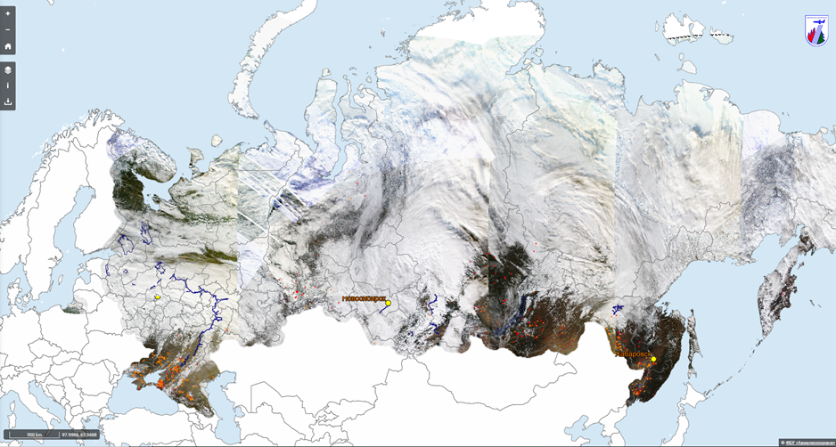
Figure 12: Interface of the interactive forest fire map on the Avialesookhrana website
Conclusion:
In this article, we have explored various remote methods and technologies for monitoring and preventing forest fires. Research has shown that the use of satellites, drones, radar systems, and thermal imaging equipment significantly enhances the detection and control of forest fires.
However, despite the advantages of remote methods, they come with limitations. Some factors such as weather conditions, vegetation density, and the presence of smoke can hinder precise fire detection. Additionally, government support and funding remain key factors for the effective implementation of these methods in practice.
In the face of climate change and the increasing frequency and intensity of forest fires, the development and improvement of remote monitoring and warning methods become an integral part of combating this global problem. Further research and innovations in this field will contribute to enhancing the fire warning system, protecting forest ecosystems, and ensuring the safety of people.
Ultimately, the use of remote monitoring and warning methods for forest fires is a promising and effective approach that will help improve response to wildfires and preserve our forest resources for future generations.
Sat-Sun: Non-working days