The 17 Sustainable Development Goals (SDGs), adopted by the United Nations in 2015, are a universal call to action to eradicate poverty, protect the planet, and ensure peace and prosperity for all people by 2030.
, adopted by the United Nations in 2015")
Sustainable land resource management is one of the key actions for achieving one of these goals set by the UN.
In particular, land is a fundamental resource for addressing climate change challenges, preserving biodiversity, maintaining ecosystem services, and at the same time ensuring universal prosperity and well-being. Therefore, it is necessary to enhance strategies for monitoring land use and vegetation cover changes to assess the current state and future prospects for human life in the coming decades and manage this resource effectively.
Specifically, the Sustainable Development Goals are an urgent call for countries to take action to preserve our oceans and forests, reduce inequality, and stimulate economic growth. To achieve this, it is essential to have characteristics, indices, and statistical indicators, including productivity, vegetation cover, soil carbon, urban expansion, and much more, to effectively manage the economy of planet Earth.
Modern land resource management systems include the concepts of land cadastre and registration. Conceptually, such a system is part of a global governance paradigm that encompasses functions such as land valuation, land ownership, development, and land use to ensure tenure security and land use rights for all. Healthy land is the key to a productive and sustainable future. Access to healthy land ensures food security and better livelihoods. It helps mitigate the adverse effects of climate change and ensures a bright future for our children.
In this context, innovative methods of collecting, processing, and storing spatial information, for example, are necessary to respond to global challenges such as urbanization, unstable agricultural development, rural poverty, and the increasing complexity of urban infrastructure.
In this sense, modern technological advancements in Earth remote sensing and geospatial information offer vast opportunities.
You can order from us
What Problems Does Remote Sensing Solve?
Rational use of land resources and effective territorial management require up-to-date information on land conditions.
Remote sensing allows for solving the following tasks:
- Development of landscape plans and topographic-geodetic base maps.
- Identification of functional zones (residential, industrial, public) in settlements.
- Creation of schemes and plans for territorial development.
- Assessment of the suitability of new areas for urban development.
- Monitoring land degradation and urban growth, which align with sustainable development goals. Information on urban land use is crucial for urban planning and sustainable development, mapping urban land use, and determining urban land use types within a city.

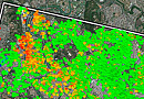
Fig.2 Desertification and land degradation - Building a functional classification system of "production-living-ecology" using remote sensing monitoring over several periods of the studied territory.
- Quantitative assessment and evaluation of land cover change rates and forest cover dynamics. Determining land cover classes at the beginning of the study period and tracking their changes across multiple levels, including actual deforestation. Forest cover loss is mainly linked to agriculture, savannas/desertification, and urbanization. Carbon stocks in forest ecosystems, released due to forest degradation, contribute to greenhouse gas emissions (Carbon Dioxide (CO2), Methane (CH4), Nitrous Oxide (N2O), Ozone (O3), etc.).
- Combining Earth observation data with field cadastre records.

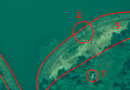
Fig.3 LCCS2 Land Use Classification 2001-2019 - Recording sustainable urbanization, land use, and vegetation cover changes using remote sensing analytics. The goal is to make cities and settlements open, safe, resilient, and sustainable.
- Textural data—contributing to solutions for combating desertification, droughts, floods, and achieving "neutral" land degradation through the overlaying of data onto remote sensing images and maps.
- Mapping modern agricultural landscapes that produce multiple ecosystem services, substantiated and practically verified by remote sensing identification methods.
- Mapping and evaluating ecosystem services in agricultural landscapes, which hinders integrating their value into the existing land-use planning system.

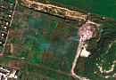
Fig.4 Mapping and assessment of ecosystem services in agricultural landscapes - Land use and land cover change (LULC) is a critical component for monitoring environmental changes and managing natural resources.
 1999-2018")
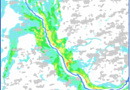
Fig.5 Land use and land cover change (LULC) 1999-2018 - Three-dimensional land management systems, often called 3D cadastre, promise several benefits, especially in managing modern complex built environments. 3D cadastre relates to urban developments and internal landscape surroundings. A three-dimensional city model is typically defined as a digital representation of the Earth's surface and the built environment within a city. Using such a model allows for the creation of citywide applications or focusing on a specific building model.

Fig.6 Three-dimensional land management systems - Mapping water reclamation, which guarantees increased agricultural land productivity but can also negatively affect land quality. Technical failures of reclamation systems, outdated reclamation technologies, poor water quality, and untimely drainage can lead to negative processes such as salinization and waterlogging.
Satellite imagery can be used to identify potential hazard zones for the population and allocate areas for sanitary protection zones. High-risk objects include certain engineering structures: factories, gas and oil pipelines, and storage facilities for gas, oil, and fuel. Space monitoring enables real-time tracking of these objects' conditions. High-resolution imagery provides current information on the status and dynamics of objects.
Aerospace monitoring methods are also applied in cadastral surveys. Images help define territory boundaries and account for property. Thanks to ultra-high resolution, small objects such as equipment and engineering structures can be inventoried.
When laying major infrastructure, disputes often arise regarding the crossing of private lands, conservation areas, and state reserves. Remote sensing helps analyze territories and select the optimal route for a gas or oil pipeline.
Aerospace surveying of the Earth's surface is essential for large-scale construction, quarry development, and mineral extraction. Space monitoring assesses the suitability of territories for construction or resource extraction. Based on the obtained data, a geographic information system can be created to manage design and construction works. Regular monitoring ensures control over construction and field development processes at all stages.
Advantages of Using Remote Sensing
- Over the last decade, there has been a growing use of unmanned aerial vehicles (UAVs), satellite and airborne data collection systems, as well as active remote sensing sensors such as LiDAR. The use of LiDAR remote sensing sensors has led to data acquisition with high spatial, spectral, radiometric, and temporal resolution.
- Additionally, significant progress has been made in automated image orientation, surface reconstruction, scene analysis, change detection, geolocation, classification, automatic feature extraction, and more.
- Image surface reconstruction, scene analysis, and change detection using artificial intelligence, spatial statistics, and machine learning applied to sustainable land use management are currently actively demonstrated, tested, and scaled.
- New open-source geospatial analysis tools and increasing availability of open remote sensing data allow for enhancing methodologies to monitor land use and vegetation cover changes, providing data applicable to other research fields or, for instance, implementing decision support systems for ensuring environmental sustainability.
- In terms of operational efficiency and territorial coverage, these remote sensing innovations far exceed fieldwork and are approaching highly detailed land research capabilities.
Application Examples:
Characterizing Land Cover and Forest Cover Changes. Land Surface and Forest Cover Change Dynamics in Togo between 1985 and 2020 Using Landsat Images
Objective: Quantitative assessment of greenhouse gas emissions in forest ecosystems—characterization of land and forest cover changes.
Solution: Carbon stocks in forest ecosystems, released due to forest degradation, contribute to increased greenhouse gas emissions. A combination of Earth observation data and field cadastral records was used for quantitative assessment of these changes. Land cover changes and forest dynamics in Togo between 1985 and 2020 were characterized using supervised classification of Landsat 5, 7, and 8 images. The overall classification accuracy for all target years ranged from 0.91 to 0.98, with Kappa coefficients between 0.86 and 0.96.
Result: The analysis showed that all land cover classes identified at the beginning of the study period underwent changes at multiple levels, with forest cover shrinking from 49.9% of the country's territory in 1985 to 23.8% in 2020. These losses were primarily linked to agriculture, savannas, and urbanization. The annual forest cover change was estimated at -2.11% per year, with an annual deforestation rate of 422.15 km², corresponding to a 0.74% annual forest cover reduction over 35 years.
 Geographic location of the study area; (B) ecological zones and elevations")

 Gradient of vegetation cover changes by region from 1985 to 2020; (B) unchanged area; (C) area with one or two changes; and (D) area with three or four changes")
Integration of Remote Sensing and Geospatial Big Data for Urban Land Use Mapping
Objective: Assessing urban land use.
Solution: Information on urban land use is crucial for urban planning and sustainable development. The emergence of geospatial big data, increased accessibility of remote sensing data, and the development of new data integration methods provide new opportunities for mapping urban land use types. However, methods of integrating remote sensing data with open and governmental databases vary due to differences in data formats, study areas, classification schemes, etc.
Urban land maps were created based on urban plots derived from open-source road network data, 10-meter Sentinel-2A images, and points of interest (POI). The classification results were quantitatively and qualitatively validated using a common test dataset.


Need for consultation?
Fill the form and we will contact you
Customers


FAQ
Land administration is the process of planning, development, utilization and protection of land and natural resources related to land use. It includes coordination and management of various aspects of land use, such as agrarian management, forestry, urban planning, development, nature conservation and environmental sustainability.
Land administration aims at the efficient use of land in accordance with the goals and needs of society, while taking into account environmental, economic and social aspects. It includes the development of land use policies, legislative norms and regulations, as well as mechanisms for controlling and monitoring land use.
The objectives of land management include ensuring food security, preserving biological diversity, preventing negative human impact on natural ecosystems, promoting sustainable development, improving the living conditions of the population and equitable distribution of land rights.
The main tasks of land resources management include planning of land use, administrative regulation of land relations, allocation and distribution of land plots, control over land use, protection of soil and water resources, regulation of land conflicts and dispute resolution.
The main tasks of land resources management include planning of land use, administrative regulation of land relations, allocation and distribution of land plots, control over land use, protection of soil and water resources, regulation of land conflicts and dispute resolution.
Land resources management is carried out by state bodies, local authorities, land experts, public organizations and stakeholders, taking into account the principles of sustainable development and public participation.
Remote sensing land management is the application of modern technology to monitor, analyze and manage land resources. It is an area where resources, rights, sites and governments interact with remotely sensed land technologies for effective land use management.
State and municipal authorities play an important role in land management by utilizing data obtained from remote sensing of land. They can use this information to make decisions on the location of facilities, planning the use of land parcels, controlling compliance with land use rules and regulations, protecting natural resources and protecting the environmental sphere.
Remote sensing of land provides a variety of data about the land, such as information on vegetation, land cover, water levels, and other environmental parameters. These data can be used to determine optimal land use, plan agricultural operations, monitor forest resources, assess ecological status, and monitor changes in the landscape.
Remote sensing of land can also help in establishing legal relations in the sphere of land use. It can be used to determine the boundaries of land plots, establish ownership rights, control land use in accordance with legislation and resolve land disputes.
Russian experience shows that remote sensing of land can be an effective tool in land management. It allows obtaining up-to-date and objective data, reduces monitoring costs and ensures more effective planning and control over land use.
Various types of activities are carried out as part of land management using remote sensing. One of them is monitoring changes in land use. Remote sensing of land can be used to track changes in land cover over time, identifying new development, changes in agriculture or forest cover. This allows the effectiveness of current land use strategies to be assessed and evidence-based decisions to be made.
Another aspect of land management using remote sensing of land is related to planning the use of land parcels. The analysis of remotely sensed data makes it possible to identify suitable land parcels for various purposes such as agriculture, industry, residential areas or protected areas. This helps to optimize the use of land resources, taking into account the requirements and needs of different sectors of the economy and society.
Also, remote sensing of land can be used to monitor compliance with land use rules and regulations. The data obtained from remote sensing can detect illegal changes in land use or violations of environmental norms. This contributes to effective control over the use of land resources, observance of rights and prevention of illegal actions.
State and municipal authorities play an important role in regulating land relations and coordinating land use activities. They monitor and analyze remotely sensed data and make decisions based on the information obtained. In addition, governmental and public organizations can use these data to develop policies and strategies for land management.
Thus, remote sensing of land is a powerful tool in land management. It provides access to a wide range of information on land cover, changes in land use and environmental conditions. This enables informed decisions to be made in the planning, administration and protection of land resources.
Remote sensing of the earth also has a number of advantages. First, it provides the possibility of obtaining data over large areas, including remote and inaccessible areas. This makes it possible to cover vast areas and obtain a comprehensive analysis of land resources.
Secondly, remote sensing of land is a prompt and efficient method of obtaining information. With the help of satellites and other means of observation, periodic measurements and monitoring of the state of the land can be carried out, which allows rapid response to changes and problems.
Third, remotely sensed land data provides objective information based on actual measurements and observations. This helps to avoid subjectivity and human error and provides a more accurate assessment of the condition and utilization of land resources.
Fourth, remote sensing of land is a tool to improve transparency and openness in land management. Access to land cover data and information can be made available to the general public, stakeholders and scientific researchers. This facilitates the participation and involvement of various actors in the land management process.
However, it should be noted that remote sensing of land is only one tool for land management and should be used in conjunction with other methods and data sources. It is also important to take into account contextual and local characteristics, socio-economic factors and community needs when developing land management strategies. Remote sensing of land should be integrated into the broader context of land management, which includes consideration of legal, social, economic and environmental aspects.
An important aspect of land management using remote sensing is the development of skills and competencies in analyzing and interpreting data, and in making decisions based on the information obtained. Training of specialists and exchange of experience between different management bodies and research institutions play an important role in improving the efficiency and quality of land management.
Russian experience in land management using remote sensing of land is considerable. Russian satellites such as Kanopus and Resurs-P are actively used to collect information on the status of land use and monitor changes in land use. This allows for informed decisions on land planning and management at various levels.
In conclusion, land management using remote sensing of land is an effective and promising approach. It contributes to optimizing the use of land resources, controlling their use and protecting the environment. However, it is important to consider a wide range of factors and interests to ensure sustainable and equitable land management in accordance with the needs of society and nature.
Land resource management includes various methods and principles that help effectively utilize and preserve land resources. Below are some of them:
- Land Zoning. Zoning is a fundamental tool for land resource management. It involves dividing land parcels into different zones with specific designations (agricultural, industrial, residential, protected areas, etc.). Zoning enables the rational use of land resources, considering their potential and the needs of different economic and social sectors.
- Land Use Planning. Land use planning involves developing strategies, policies, and programs for land resource management. It is based on data analysis, land potential assessment, and consideration of socio-economic factors and community needs. The goal of land use planning is to optimize land resource utilization, maintain ecological sustainability, and ensure socio-economic development.
- Regulation and Licensing. Government and municipal authorities establish laws, rules, and norms regulating land use. This includes obtaining permits and licenses for land use, monitoring compliance with regulations, and applying sanctions in case of violations. Regulation and licensing help ensure the sustainable and responsible use of land resources.
- Monitoring and Evaluation. Monitoring and evaluating land resource conditions are crucial management components. They provide up-to-date information on land use changes, soil conditions, water quality, and other environmental parameters. Monitoring and evaluation help identify problems, assess strategy effectiveness, and make informed decisions based on factual data. Remote sensing, geographic information systems, and other technologies play a vital role in land resource monitoring and evaluation.
- Public Participation. Public participation is an essential principle in land resource management. It involves engaging stakeholders, such as local residents, non-governmental organizations, and representatives from various economic sectors, in land use decision-making. Public participation promotes transparency, fairness, and legitimacy in land resource management.
- Ecological Sustainability. The principle of ecological sustainability entails preserving and restoring the ecological integrity of land ecosystems. Land resource management should consider the impact of human activities on nature, take measures to prevent soil degradation, water pollution, and biodiversity loss. Ecologically sustainable land management contributes to the long-term preservation of natural land functions and the maintenance of ecosystem services.
- Efficient Land Use. The principle of efficient land use involves maximizing the potential of land to meet social, economic, and environmental needs. It includes optimizing agricultural production, promoting sustainable urban planning, reducing land losses due to erosion and other processes, and rationally utilizing unused land parcels.
- Consideration of Rights and Interests. Land resource management should respect the rights and interests of various population groups, including local communities, indigenous peoples, and small-scale farmers. This includes protecting land rights, ensuring fair land resource distribution, and recognizing traditional land use systems. Considering rights and interests helps ensure fair and sustainable land management, prevent conflicts, and promote social justice.
- Integrated Approach. Land resource management should be carried out using an integrated approach that considers the interconnection of various land use aspects and balances economic, social, and environmental needs. An integrated approach fosters synergy between different policies and activities, ensures sustainable development, and minimizes negative environmental impacts.
- Continuous Learning and Research. Land resource management requires ongoing training and skill development for specialists, as well as scientific research to develop innovative methods and approaches. Education and research contribute to improving land resource management quality, enhancing practices, and enabling evidence-based decision-making.
These methods and principles of land resource management are interconnected and complement each other, ensuring the sustainable and efficient use of land. Their implementation requires collaboration among various stakeholders, effective use of information and technological resources, and consideration of contextual and local specifics in strategy and policy development.
Licenses


Our partners


")


")

Sat-Sun: Non-working days