Object contour feature extraction (object detection) is the process of finding instances of objects in an image. When recognizing objects, it not only establishes the presence of an object in the image but also determines its location.

Object detection is achieved through contour search.

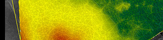
Contour search involves a set of mathematical methods aimed at identifying points in a digital image where the brightness of the image changes sharply. These points are organized into a set of curved lines and are called edges, boundaries, or contours.

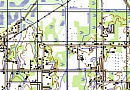
Extracting contour features of objects in cartography allows for creating precise and informative maps with high detail. Contour features are used to highlight the boundaries of objects on the map and provide important information about the shape and location of these objects.


Purpose of Object Detection

Extracting contour features of objects allows obtaining detailed information about the shape, size, and location of objects on the ground, which has a wide range of applications in various fields related to cartography and geospatial analysis.

Extracting contour features of objects is an essential tool for creating accurate maps, conducting terrain analysis, resource planning and management, working with GIS, and providing navigation and route planning. It plays a crucial role in various sectors, from urban planning and design to ecology and tourism.

Extracting contour features of objects in cartography serves several primary purposes and tasks:

  1. Creating accurate maps: Extracting contour features allows for the creation of more precise and detailed maps, as object contours provide information about their shape and location. This is particularly crucial in map creation for urban planning, transportation route planning, natural resource assessment, and other tasks requiring high accuracy and reliability of data.

  2. Improving visual representation: Extracting contour features also enhances the visual representation of maps. Smooth and aesthetically pleasing contours make cartographic images more readable and attractive to users. This is especially important in creating maps for public use and data visualization.

  3. Spatial data analysis: Extracting contour features allows for a deeper analysis of spatial data on the map. Object contour features can be used to measure area, determine orientation and shape of objects, and identify relationships between different entities. This aids decision-making in various fields such as geographic information systems, ecology, urban planning, and more.

  4. Improving navigation and orientation: Extracting contour features helps enhance navigation and orientation on the map. Contour features enable the identification of boundaries and shapes of roads, rivers, lakes, buildings, and other objects, assisting users in better understanding spatial arrangements and selecting optimal routes. This is particularly useful for travelers, drivers, and tourists.

Prices for services

Activities

Free / Cost per unit of measurement

Consultation

Free

Collection of images (if necessary), preliminary analysis of source data, additional and reference materials

Free

Ordering images (if necessary)

From 0.5 to 70 USD per 1 km2 depending on the type of imagery (archive-new, mono-stereo, resolution) *

Cost of creating a GIS project

From 1 USD per 1 km2, calculated individually for each specific order and depends on the amount of processed remote sensing data, presence (absence) of control points, and the used mapping coordinate system.

Cost of thematic processing of remote sensing data

Cost of extracting contour features per 1 km2 starting from 200 rubles and depends on the complexity category and execution time.

Execution time

From 20 working days (depends on the volume, complexity category, availability of remote sensing data, additional and reference materials)

* working days

** from the date of receiving 100% advance payment for remote sensing data materials. The completion time depends on the number of km2, the type of product being created, the availability of archival remote sensing data, additional and reference materials.

The cost of execution is calculated on an individual basis, taking into account a specific of task.

After receiving the task description, we calculate the cost and send you a commercial offer.

Period of execution

Coordination of questions, analysis of the availability of remote sensing data, additional and reference data

From 1 to 5 days*

Contract signing

From 1 to 5 days*

Receipt of images

From 3 to 10 days **

Receipt of source material (paper plan or scanned)

From 1 to 20 days*

Creation of GIS project for information refinement

From 5 days*

Thematic processing

From 15 days*

Conducting controls

From 5 to 10 days*

Preparation of technical report on work execution

From 5 to 10 days

TOTAL TIME

From 20 days*

* working days
** from the date of receiving 100% advance payment for remote sensing data materials. Completion time depends on the number of km2, the type of product being created, the availability of archival remote sensing data, additional and reference materials.

How to place an order:

STEP #1: Submit a request on the website with the following details:

  • Area (coordinates, district name, region, shapefile, etc.);

  • Requirements (scale, creation-refinement);

  • Requirements for remote sensing data, additional, and reference data;

  • Deadline for completion of work.

STEP #2: Coordination of the technical task and cost:

  • Purchase of remote sensing data, images are paid separately (from $8 to $70 USD per 1 km2 depending on the type of imagery - archive-new, mono-stereo, resolution).

  • Coordination of the work execution technology, requirements for the created product.

STEP #3: Signing the contract and starting the work:

The start date for creating GIS projects for contour feature extraction is 5 working days from the date of receiving 100% advance payment for remote sensing data materials - payment is only accepted by non-cash settlement. Thematic processing starts within 3 days after the start of creating GIS projects.

We work with individuals and legal entities, individual entrepreneurs, government and municipal authorities, foreign clients, etc.

You can also send your request via email: innoter@innoter.com, or contact us by phone: +7 495 245-04-24, or use the online chat on the website.

Need for consultation?

Fill the form and we will contact you

By clicking the «Send» button, you give your consent to the processing of your personal data, in accordance with Federal Law No. 152-FZ of July 27, 2006 «On Personal Data», on the conditions and for the purposes specified in the Consent to the processing of personal data.

Stages of service provision

Stage #0 (Before Contract Signing) – Express Evaluation:

  • Define the purpose of the created product;

  • Coordinate technical issues;

  • Check the availability of archive remote sensing data (DZG) in the area of interest;

  • Verify selected archive images for compliance with customer requirements;

  • Request new imagery from operators if necessary.

RESULT: Possibility (YES/NO) of providing the service.

Stage #1 (Before Contract Signing) – Development of Technical Task, Project of the Contract:

  • Coordinate with the customer on available archive DZG data or ordering new imagery;

  • Determine work technology, coordinate with the customer the methodology and deadlines;

  • Agree on coordinate system and projection requirements for the final product;

  • Agree with the customer on the technical task for the entire scope of work;

  • Final determination of labor and material costs, agreement on delivery times and costs.

RESULT: Signed Contract.

Stage #2 (Contract Execution):

  • Receive advance payment (100% prepayment for the purchase of DZG materials);

  • Order DZG materials;

  • Input control of DZG materials;

  • Check the quality of received materials from the customer;

  • Prepare, coordinate, and approve editorial-technical instructions with the customer;

  • Create digital orthophotoplans necessary for the task;

  • Thematic processing of the specified area (contour feature extraction);

  • Perform visual and automated control of the created product;

  • Export the created (updated) project to the required formats, projection, and coordinate system;

  • Write a technical report.

The result of the provision of services

The customer receives the following results:

  1. Contour lines of objects: The customer receives a set of contour lines that describe the shape and sizes of objects on the ground. These contour lines can be presented as vector data, where each line is represented as a sequence of points.

  2. Geometric parameters of objects: The customer can also obtain information about the geometric parameters of objects, such as area, perimeter, length, and width. These parameters can be useful for the analysis and comparison of objects on the ground.

  3. Attribute data: In addition to geometric parameters, the performer can also extract attribute data of objects. These data may include information about the type of object, its name, classification, as well as other characteristics that can be useful for the analysis and use of cartographic data.

  4. Graphic representation of objects: As a result of contour feature extraction, the customer can create a graphic representation of objects on the ground. This can be in the form of a map where objects are represented by contour lines and attribute data, or in other graphic formats that can be used for further analysis and visualization of data.

All results are delivered on electronic media or via the Internet through FTP servers, and textual materials are also duplicated in printed form.

Requirements for Source Data

If it is not possible to provide the specified information or the purpose of using the obtained data, the specialists of "GEO "INNOTER" LLC will analyze the requirements and propose an optimal solution to the problem.

Related services

Orthoimagery (Orthorectification)
Find out the price
Photogrammetric processing (Image Processing)
Find out the price

Customers

Rosneft
Gazprom
Gazprom neft
Lukoil
Transneft

FAQ

  • area of interest (location / coordinates of the object in any convenient form, and the area of the object);
  • the specific task to be solved with the application of the product to be created.

As the main material for creation (update) of the data project the RS data available in archives of spacecraft operators for the most current date are used, or new imagery is ordered. In addition, when creating (updating) the data project, additional and reference materials are used in the form of various geographical descriptions, large (small) scale maps and atlases, reference books, as well as data available to the Customer.
  • Terms of thematic processing based on space or aerial survey data depend on the volume and complexity of the order. Minimum term - from 10 (ten) working days;
  • Terms of delivery of finished products from 5 (five) working days.
100% prepayment by invoice after signing the contract.

Object detection in an image is the process of automatically identifying and localizing various objects or regions of interest (ROI) in a digital image. This is a crucial task in the fields of computer vision and machine learning, finding applications in various areas, including automatic face recognition, vehicle detection, medical diagnostics, image annotation, robotics, video surveillance, and more.

Various methods and algorithms are employed for object detection in images. Some of the most popular methods include:

  1. Classical computer vision methods:

    • Haar Cascade Methods.
    • Edge and contour processing methods.
    • Template matching methods.
  2. Machine learning methods:

    • Feature-based object detectors (e.g., HOG, SIFT, SURF).
    • Machine learning-based object detectors, such as Support Vector Machines (SVM), Random Forests, Neural Networks, etc.
  3. Deep learning:

    • Convolutional Neural Networks (CNN) are the most popular method for object detection in images. Networks like Faster R-CNN, YOLO (You Only Look Once), and SSD (Single Shot MultiBox Detector) provide high accuracy and detection speed.

The object detection process in an image typically involves the following steps:

  1. Load the image.
  2. Apply the object detector (e.g., a neural network) to search and localize objects.
  3. Determine the classes of objects (e.g., "cat," "dog," "car").
  4. Visualize the results with annotated bounding boxes or object labels.

Object detection in images is a crucial component of many applications that require the analysis of visual information. The accuracy and speed of detection may vary depending on the chosen method and model, so selecting an appropriate approach depends on specific requirements and the context of the task.

Detecting objects in images used in cartography is crucial for creating accurate maps and Geographic Information Systems (GIS). In cartography, object detection in images may involve the following tasks:

  1. Road and Infrastructure Detection: Roads, bridges, bus stops, and other infrastructure elements can be automatically identified in images using computer vision and image processing methods. This can aid in creating and updating road maps.

  2. Building Detection: To create maps of cities and settlements, it is important to determine the location and outlines of buildings in images. This can be useful for urban development planning and property assessment.

  3. Natural Object Detection: Identifying mountains, lakes, rivers, and other natural features in images helps create more informative maps of the environment and rural areas.

  4. Boundary and Geographic Object Detection: For creating administrative maps and maps of country and region borders, detection methods can be used to automatically locate and mark boundaries and geographic objects.

  5. Transport and Motion Detection: For monitoring traffic movement on roads and railways, as well as determining traffic density and flow, object detectors based on video stream analysis can be employed.

  6. Point of Interest Detection: This may include detecting objects such as geodetic beacons, traffic lights, road signs, and other elements crucial for navigation and orientation on maps.

To accomplish these tasks, both classical computer vision methods (e.g., edge detectors, image segmentation) and modern deep learning methods, such as Convolutional Neural Networks (CNN) and object detectors trained on large datasets, can be used.

When detecting objects in images in cartography, it is also important to consider the georeferencing of data to correctly position objects on the map according to geographic coordinates.

Object detection in remote sensing plays a crucial role in extracting contour features from imagery, enabling the identification and mapping of distinct objects or structures on the Earth's surface. It aids in applications such as land cover mapping, urban planning, and environmental monitoring.
Classical computer vision methods, such as edge detection and image segmentation, contribute to the extraction of contour features by identifying boundaries and edges within remote sensing data. These techniques help outline the shape and structure of objects, facilitating subsequent analysis.
Challenges in remote sensing object detection include issues like varying illumination conditions, sensor noise, and the diversity of object shapes and sizes. Additionally, the presence of occlusions and complex backgrounds can complicate accurate contour feature extraction.
Deep learning methods, particularly CNNs, enhance object detection in remote sensing by automatically learning hierarchical features from data. CNNs excel at capturing intricate patterns, improving the accuracy of contour feature extraction in diverse and large-scale remote sensing datasets.
Georeferencing is essential in remote sensing object detection to ensure the correct spatial positioning of identified objects on the Earth's surface. It enables the integration of remote sensing data with geographic coordinates, facilitating accurate mapping and geospatial analysis of contour features.

Licenses

License for implementation of geodetic and cartographic activities (page 1)
License for implementation of geodetic and cartographic activities (page 2)
Application for the license for implementation of geodetic and cartographic activities
ISO 9001:2015 Certificate of Conformity №СДС.ФР.СМ.00813.19 (page 1)
ISO 9001:2015 Certificate of Conformity №СДС.ФР.СМ.00813.19 (page 2)

Our partners