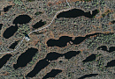
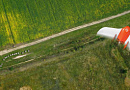
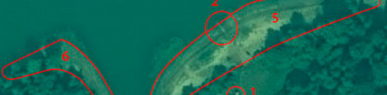
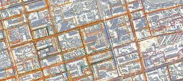
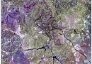
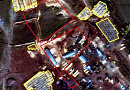
Remote sensing imagery Interpretation & spectral analysis - is the process of recognizing objects and territories, their properties, and interrelations based on their images in the captured satellite or aerial imagery.
Decoding of can be done through fieldwork or through office work. Office decoding is further divided into visual and automated decoding. Visual decoding is performed manually by an interpreter who visually identifies and decodes the objects on the image.
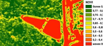
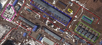
Automated decoding (machine decoding) is performed by an interpreter using specialized software and algorithms. Machine decoding involves various methods that group objects based on certain decoding features and essentially boils down to different classification mechanisms. Image classification can be categorized as supervised classification (Minimum Distance Method, Spectral Angle Method, Mahalanobis Distance Method) and unsupervised classification (ISODATA Method, K-Means Method).
The Importance of Remote sensing imagery Interpretation & spectral analysis
Decoding remote sensing materials (satellite and aerial images) is conducted to obtain information about the spatial distribution of geographic objects, their occupied areas, and to identify the dynamics and characteristics of such objects.
Depending on the tasks to be accomplished, decoding of satellite images can be classified as general decoding (comprehensive or geographic) and specialized decoding (thematic or specific).
Interpretation & spectral analysis satellite images involves preliminary and main stages, which include data processing, brightness normalization for different object types, creation of mosaic coverages, etc.
The results of decoding are documented in graphical, digital, or textual formats.

You can order from us


Prices for services
| Consultation | Free of charge |
|---|---|
| Decoding of remote sensing images spectral analysis | The cost of the work is calculated individually for each order and may vary depending on the complexity and volume of the work. |
| Work of Technical Specialists and Experts | Starting from 100,000 rubles |
| TOTAL COST | Starting from 100,000 rubles |
The cost depends on:
- Area of the area of interest (work area);
- Number of images;
- Quality characteristics of the images;
- Complexity of the terrain;
- Seasonality of work;
- Size of the advance payment;
- Task complexity;
- Requirements for computational power;
- And more.
The cost of execution is calculated on an individual basis, taking into account a specific of task.
After receiving the task description, we calculate the cost and send you a commercial offer.
Period of execution
Completion time for decoding remote sensing images spectral analysis is approximately 10 working days from the date of receiving the advance payment and is calculated individually for each customer.
The completion time of the work depends on:
- Total area of the area of interest;
- Requirements for the final result.
The service delivery time depends on the complexity of the work and is calculated individually for each customer.
How to place an order:
Need for consultation?
Fill the form and we will contact you
Stages of service provision
The result of the provision of services
Stage № 0 (BEFORE contract conclusion):
- Receipt and coordination of data from the Customer. It is necessary to coordinate the task requiring a solution, the size, nature of the area, and the requirements for creating the product to calculate the cost and timeframe for the work.
RESULT: possibility (YES/NO) of providing the service
Stage № 1 (BEFORE contract conclusion):
- Agreement on technical specifications
- Final determination of labor costs, agreement on deadlines, and costs
RESULT: signed contract
Stage № 2 (contract execution):
- Processing of remote sensing data (DZZ);
- Decoding of remote sensing data (DZZ);
- Verification of the obtained result;
- Preparation of the final report.
- RESULT: Transfer of materials to the Customer.
Related services


Completed projects

Customers


FAQ
- acceptable accuracy of spatial geolocation of images;
- spectral range of shooting: panchromatic, multispectral (color), color with near-infrared channel, color with short-wave near-infrared channel;
- the angle of deviation of the image from the nadir, for example, up to 20 degrees or up to 10 degrees;
- radiometric resolution of images, for example, 8 bits /16 bits (the higher the resolution, the more brightness gradations can be seen in the image);
- the percentage of clouds in the image, for example, is no more than 20%;
- snow cover in the images (20% of the area).
If space image processing is required, the requirements are discussed with the Contractor.
Licenses


Warranty
Resolution of the Government of the Russian Federation: of June 10, 2005, No. 370 "On the Approval of the Regulation on Planning of Space Imaging, Reception, Processing, Storage, and Distribution of Earth Remote Sensing Data from Civilian Spacecraft with High (less than 2 meters) Resolution" (with amendments and additions); of July 7, 2015, No. 682 "On the Powers of Federal Executive Authorities in the Field of Using the Results of Space Activities"; three orders of "Roscosmos" on the Federal Fund of Earth Remote Sensing Data from Space; six Russian Government Resolutions on the Federal Fund of Earth Remote Sensing Data from Space.
As of March 30, 2022, 36 Remote Sensing Data Standards have been approved by orders of Rosstandart.
At the international level, remote sensing activities are regulated by the following foundational acts:
- Convention on the Transfer of Data and the Use of Remote Sensing Data from Space (concluded in Moscow, May 19, 1978).
- Principles relating to Remote Sensing of the Earth from Space (adopted by Resolution 41/65 of the United Nations General Assembly on December 3, 1986).
We guarantee that all work will be carried out in accordance with SNiP, GOST, and SP., using advanced methodologies and state-of-the-art software.
We ensure 100% service quality. By collaborating with GEO Innovations specialists, you eliminate risks and losses.
Our qualified personnel, experienced in working with specialized software, allows us to provide these guarantees!
Our partners


")


")

Articles
Sat-Sun: Non-working days