The telecommunications industry is currently the fastest growing industry, due to the technological progress of wireless technologies and the development of Internet technologies. Accelerating the design and construction of new networks, upgrading existing infrastructure and improving the quality of service networks are the main tasks in the field of Telecom infrastructure management.
The basis of an effective management and development system, as well as network design, is the introduction of geoinformation systems and geospatial data.
Geospatial data is necessary for solving a number of urgent tasks in the telecommunications industry:
- spatial analysis of existing networks and the environment;
- spatial analysis and modeling in network planning;
- site selection with appropriate calculations for cellular antennas, PCS radio ports, fiber nodes, repeaters;
- determining the optimal route for cable laying, taking into account the Central lines of streets and Railways, as well as various underground utilities;
- determining the optimal location of radio relay lines based on surface profiles;
- optical visibility from certain points (antenna locations).
- modeling of radio wave propagation and analysis of their zones of action;
- getting geographically linked measurements of the electromagnetic field (GIS+GPS) and its analysis;
- spatial data (physical network, land use, etc.) as an integral part of the operational database system.
GEO INNOTER LLC develops the following types of DSM:
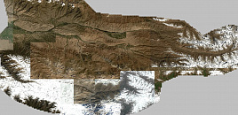
- 3D models for urban planning of large cities, administrative and industrial centers, cities with a high level of network penetration of the latest technologies, cities with a high level of new construction;
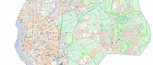
- 2.5 D-models for smaller cities, cities with a low level of construction; individual territories of large cities with low population density and suburbs;
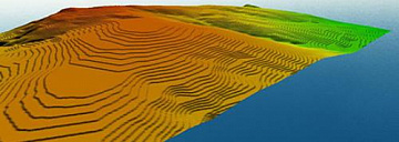
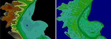
- 2D-regional models for areas that cover large territories; digital terrain models, digital elevation models, and clutter models.
DSM created by GEO INNOTER LLC on the basis of its own innovative technologies have a high level of accuracy required by communication network operators. To create a DSM, materials available in the Federal cartographic and geodetic Fund (FCGF), Rosreestr materials, earth remote sensing materials, space survey materials, aerial photographs, and digital orthophotos are used as the source cartographic material.