
You can order from us


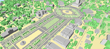
Goals and Objectives of 3D City Modelling (Digital twins) Services:
The tasks are determined by the capabilities of the software, which allows solving the main directions of high-detail imaging and measurements:
- Creating a 3D topographic base for design and survey works;
- Geometric 3D measurements of engineering structures;
- Updating 3D maps of the terrain;
- Building mathematical models using the intensity of laser pulse reflections;
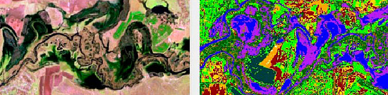
- High-precision decoding of terrain objects;
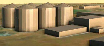
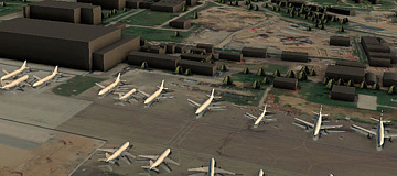
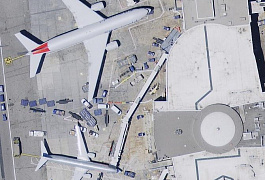
- 3D models for thematic mapping, especially for complex construction projects (bridges, interchanges, ports, train stations, airports, quarries, etc.), BIM, CAD-CAM, and other modern construction technologies.
Thus, 3D modeling is commonly used in urban planning, industrial and infrastructure construction, forestry, emergency situations, geology, development of coastal marine and river areas, and more.
Advantages of Using Remote Sensing Data
- Conduct detailed studies from a distance;
- Perform visual assessments of the spatial arrangement of objects considering terrain features and their heights;
- Analyze the spatial arrangement of various industrial infrastructure structures;
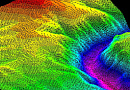
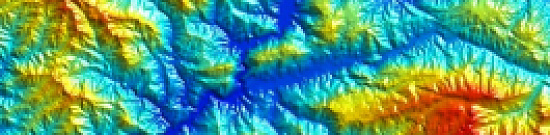
- Obtain and evaluate the true relief of the terrain;
- Select objects on the model to obtain semantic information, edit the appearance and characteristics (semantics) of objects, perform measurement and calculation operations, determine coordinates, and conduct detailed terrain evaluations in office conditions.

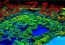
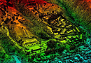
Rostov Veliky, Kremlin fragment using a combination of video and digital photos, visible and IR images from UAV.
Prices for services
| Consultation | Free of charge |
|---|---|
| Data collection, preliminary analysis | Free of charge |
| Ordering Remote Sensing Data | From $1 to $500 per 1 km2, depending on the type of remote sensing data (satellite imagery, aerial photography, point clouds, etc.) * |
| Execution Period | From 15 working days (depending on the volume, complexity category, and availability of archival remote sensing data) |
The price depends on the requirements and is calculated individually for each customer.
The cost of data collection and object modeling using aerial laser scanning (ALS) methods is generally comparable to traditional surveying methods, and on large areas or distances, the cost is lower.
The cost of execution is calculated on an individual basis, taking into account a specific of task.
After receiving the task description, we calculate the cost and send you a commercial offer.
Period of execution
The deadline is from 15 (fifteen) working days and is calculated individually for each Customer.The deadlines depend on the complexity category of creating a remote sensing model, the number of processed remote sensing source data and is calculated individually for each Customer.
How to place an order:
Need for consultation?
Fill the form and we will contact you
Stages of service provision
Stage 0 (PRE-Contract) - Express Assessment:
- Agreement on the task that requires creating a 3D model.
- Evaluation of the technical feasibility of solving the Customer's task using remote sensing methods. Assessment of the Customer's equipment performance and resources for 3D modeling.
- Determination of dates and parameters for the desired aerial, spaceborne, or laser survey (period, type, etc.).
- Checking for the availability of archival materials for the area of interest.
- Verification of selected archival stereo images to meet the Customer's requirements.
- Requesting operators for new or speculative surveying (if necessary).
RESULT: Possibility (YES/NO) of providing the service.
Stage 1 (PRE-Contract)
- Ordering aerial or satellite imagery from scratch.
- Agreement with the Customer on the format of 3D data.
- Agreement with the Customer, if necessary, on the type of aerial or UAV apparatus for new surveying, as well as its timeframe and parameters.
- Final determination of labor and material costs, agreement on delivery deadlines and cost.
RESULT: Signed contract.
Stage 2 (Contract Execution):
- Receiving 100% advance payment for Remote Sensing Data (RSD) materials.
- Conducting the survey (spaceborne, aerial, or UAV).
- Deciphering.
- 3D modeling.
- Integration of 3D data into GIS.
If it's construction monitoring:
- Topographic plans and GIS layers.
- High-precision digital elevation models and digital terrain models.
- 3D models of objects (CAD, 3D MAX, DGN), including textured models.
- Dimension sheets and specifications of various objects.
- Profiles, cross-sections, and sections of objects.
- Virtual 3D models of the terrain and video flyovers. Multimedia.
RESULT:
The results of the performed work are delivered to the Customer in electronic format, in the formats agreed upon in the Technical Specification.
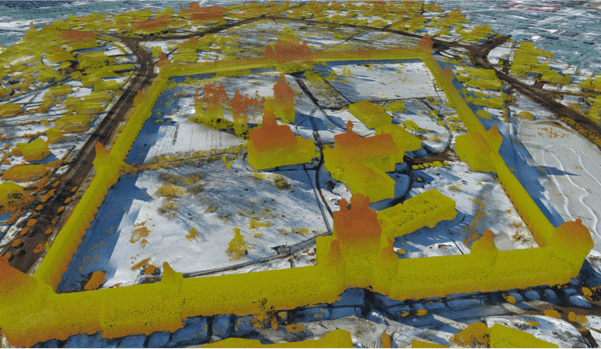
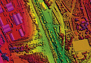
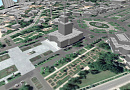
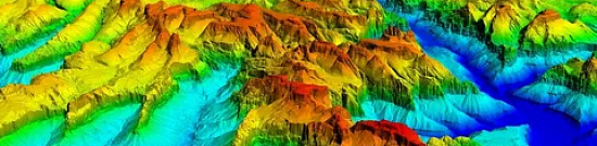
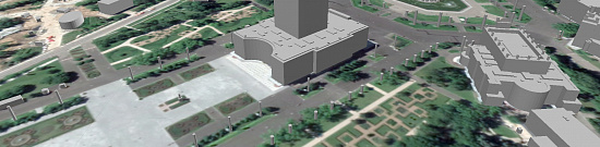
Figure: CMM of the "Borisoglebsky Monastery Ensemble." Russia.
The result of the provision of services
Creation of the final product based on Remote Sensing Data (RSD), according to the Customer's Technical Specification:
- 3D models integrated into topographic plans at scales of 1:2,000 - 1:10,000;
- Results of object monitoring with detected changes in 3D.
- 3D topographic plans integrated into GIS layers.
- High-precision digital elevation models and digital terrain models. Generation of DEM/DTM based on stereo images obtained from spaceborne, aerial, or UAV platforms. Digital Height Matrix (DHM).
- Multimedia video of the terrain with a flyover of the 3D model.
- Orthophotoplans complementing the spaceborne stereo data with laser scanning for increased accuracy, as per the Customer's Technical Specification;
- Perspective aerial photographs (only for airborne laser scanning) as per the Customer's Technical Specification.
- New spaceborne stereo imagery or aerial frame scanning (UAV). Point cloud data. Convenient image formats for the Customer.
- Information about objects and territories obtained through spaceborne or laser scanning.
GEO INNOTER delivers the finished products to the Customer who requested the satellite imagery, according to the Technical Specification, on electronic media or via the Internet using FTP servers.
Requirements for Source Data
Accurate coordinates of the area of interest, requirements for spaceborne or laser survey materials (ground resolution, type, maximum off-nadir angle, minimum solar angle, maximum allowable cloud cover percentage, survey period, point cloud density).
If it is not possible to provide the specified information, please provide details about the intended use of the 3D model, and specialists from GEO INNOTER will analyze the requirements and propose an optimal solution.
Related services


Completed projects

Customers


FAQ
- The task to be solved using remote sensing data;
- the territory of interest (location / coordinates of the object in any convenient form, and the area of the object);
- the date or time interval for which you can select an archive survey or perform a new one;
- shooting requirements
- As a rule, the minimum order area for archival satellite images is 25 km2, and for new space photography – 100 km2. The minimum order bandwidth (the distance between the two nearest points), depending on the operator of the spacecraft, the shooting mode and the product, can be from 3 to 5 km.
- For new and archival surveys: If the area of interest is a set of separate, unrelated polygons, the area of each of which is less than the minimum area to reduce the total cost, it is advisable to combine them into polygons, the area of each of which will be greater than the minimum area of the order.
- As the technology becomes cheaper, lighter and smaller, more and more industries are starting to use laser scanning.
- The deadlines depend on the area, the requirements for the shooting parameters. The minimum execution period is from 15 working days.
- 100% prepayment on the invoice for remote sensing materials after signing the contract, the rest of the payment after completion.
Licenses


Warranty
We guarantee 100% quality of service. By collaborating with GEO INNOTER specialists, you eliminate risks and losses!
The presence of qualified staff with extensive experience in working with specialized software allows us to guarantee timely and high-quality execution of projects!
Advantages of Collaborating with GEO INNOTER
- Years of experience in the field;
- Direct distributor agreements with spaceborne imaging operators;
- Experience in executing projects of any complexity, both based on aerial photography and spaceborne imagery;
- Availability of modern software for processing remote sensing data;
- Robust server capacities for processing remote sensing data;
- A team of highly skilled professionals in the fields of cartography and photogrammetry;
Our partners


")


")

Sat-Sun: Non-working days