of geospatial solutions
Sat-Sun: Non-working days
24 free satellite imagery. High resolution satellite imagery free
Many people still do not know where to find free archived space images. We present you a list of services where anyone can find the necessary satellite images for free.
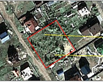
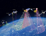
Land and land and property disputes
The article reveals the potential of using aerospace imagery in judicial and pre-trial disputes as an objective means of confirming the situation on the ground on a certain date, provides examples of the use of geospatial methods to collect evidence in resolving conflict situations, including land and land-property disputes.
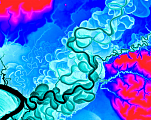
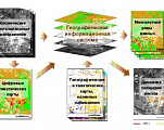
Spatial resolution
This paper analyzes the essence and significance of spatial resolution, its impact and prospects in the modern world of information technology and scientific research. It also describes the spatial resolution of drones, radar satellites, lidar imaging.
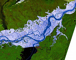
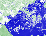
Flood and flood monitoring
The article deals with the importance and necessity of flood and inundation monitoring to ensure public safety and the preservation of material assets. The article discusses the objectives of flood and inundation monitoring, methods of flood and inundation monitoring, in particular remote monitoring.
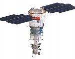
Characteristics of Russian RS spacecraft in orbit and end-of-life (ordering only archival imagery), ultra-high, high and medium spatial resolutions
Russia was the first country that opened the world market of detailed remote sensing data (2-10 meters resolution) in 1991. The state authorized to sell satellite images of Resurs F and Kometa satellites to the foreign market through Sovinformsputnik CJSC.
Elevation matrix
The height matrix is nowadays used in remote sensing (RS) to create a three-dimensional model of the Earth's surface and analyze its characteristics such as relief, height contours, slope, etc. This improves the quality of map products, allows for more accurate recognition of objects on the Earth and allows the results to be used for various applications such as urban planning, assessment of navigational capabilities and disaster forecasting.
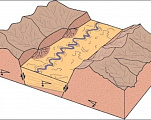
Lineament analysis
This article discusses the application of lineament analysis in the context of geological and oil and gas research. The main advantages and possibilities of this method are discussed, as well as its role in understanding the structures of the Earth's surface and its environment. The advantages of using remote sensing in lineament analysis are analyzed. Examples of the application of lineametry in specific scenarios of geological and oil and gas studies are discussed.
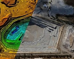
Calculation of insurance risks using remote sensing of the earth (RS) materials
This article discusses methods of insurance risk assessment using remote sensing of the earth (RS). The application of this method for analyzing and assessing insurance risks or evaluating the occurrence of insurance claims will be discussed in detail. The article will help readers understand the benefits of using remote sensing in insurance risk assessment, and demonstrate its importance for effective management and minimizing potential losses.
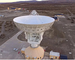
Chinese Earth stations receiving remote sensing information from national and foreign spacecraft
The article reveals the situation on the Chinese market of Earth stations for remote sensing data reception, provides a list of the main Earth stations for remote sensing data reception in the interests of the Chinese side, gives an overview of the market place (major players, manufacturers, regulator), and identifies trends.
Environmental studies using remote sensing methods
After reading this article, the reader will learn about the practical benefits of environmental research using remote sensing techniques.
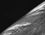
Old satellite images
After reading this article, the user will learn the history of satellite images, learn the technology for their creation, and will also be able to find out in which areas and areas of activity old satellite images are still used.
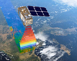
Multispectral imaging
Multispectral imaging is a method of obtaining information about the properties of objects by analyzing their interaction with electromagnetic radiation in different wavelength ranges.
Hyperspectral imaging
Hyperspectral images have high spectral but low spatial resolution, while multispectral images are characterized by high spatial but low spectral resolution.
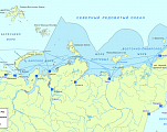
Monitoring of the Northern Sea Route
In this article we will review the significance and benefits of monitoring the Northern Sea Route using remote sensing techniques, as well as the main technologies and approaches used for data collection and analysis.
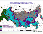
Remote methods of forest fire monitoring and prevention
This article presents an overview and analysis of remote sensing methods for monitoring and preventing forest fires. Nowadays, worldwide climate change is making itself increasingly felt.
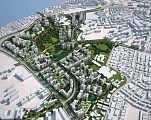
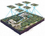
Urban Planning. Digital twin of the city
This paper looks at contemporary projects and technologies in urban planning. Projects such as GEOURBAN, UN-Habitat and others are examples of such programmes. The article describes how these projects use remotely sensed data to improve urban infrastructure and its management.
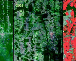
Assessment of land desertification by remote sensing methods
This article reviews key methods for assessing desertification. Desertification forecasting plays a key role in combating the global environmental crisis, helping to identify vulnerable regions, solve problems quickly, and take measures to preserve fertile land and biodiversity.
Map scales 1:10,000, 1:25,000, 1:50,000, 1:100,000, 1:200,000
A topographic map is a primary source of information about an area. Using this kind of information can open the door to lots and lots of possibilities in completely different fields. From construction to archaeology, from planning your own vacation, to monitoring the environmental situation of an area.
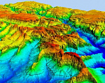
Relief Analysis. Terrain Analysis
In this article, the reader will learn what methods of analyzing the roughness of the earth's surface exist and their purpose.
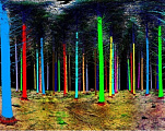
Application of remote sensing methods in forestry
After reading this article, the user will get the main thing - information and ways to solve by remote sensing methods on forest "forest health", down to the indicators of individual trees, monitoring as an effective tool for control and dependence of ecology on the Earth on the given forest area, the state of the forest area, damage from forest fires and clearcu
Sat-Sun: Non-working days