Geological modeling or geomodeling is the creation of representations or numerical equivalents of parts of the Earth's crust, both on and beneath its surface.

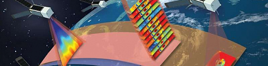
Geological modeling (geomodelling) is an applied science that involves creating computerized representations of parts of the Earth's crust based on geophysical and geological observations.

Geological modeling (geomodeling) is associated with the concept of a comprehensive Earth model (an interdisciplinary, interoperable, and updatable knowledge base about the Earth's subsurface). Geological modeling (geomodeling) is used for managing natural resources, identifying natural hazards, and quantitatively assessing geological processes, primarily applied to oil and gas fields, groundwater aquifers, and mineral deposits.

Geomodel prim.
Figure 1: Example of Geomodeling

What is geological modelling (geomodelling) used for:

  • Reliable geological data and a well-constructed geological model form the basis for accurate mineral resource estimation, which in turn determines financial and operational decisions throughout the entire value chain of the project.
  • Geological models help determine the volume and concentration of valuable minerals, which are subject to economic constraints for assessing the economic value of mineralization.
  • Geological models encompass all aspects controlling mineralization at the deposit, including factors influencing geotechnical stability, geometallurgical recovery, and waste characterization.
  • Advancements in geological modeling, particularly implicit modeling, have allowed geologists to visualize and model geology in 3D rather than using the traditional 2D sectional approach. This enables quick incorporation of more extensive datasets into the model.
  • Investing time and effort in geological modeling during the early stages reduces geological uncertainty in the project and leads to cost savings on drilling for expansion and grade control and reduces the time needed to update future geological models with new data.
  • Three-dimensional geological models characterize the structure of rock formations and deposits in the subsurface, providing sophisticated tools for a deeper understanding of geology. They are used for decision-making and supporting comprehensive analyses of soil conditions, groundwater systems, resource assessment, and reserves estimation. 3D modeling yields reliable results and increased information, making it essential for practical applications, using the three-dimensional spatial structure of each layer as the boundary for modeling.
Работник

Advantages of Using Remote Sensing Data

Modern remote sensing tools include LiDAR and digital elevation models, high-resolution optical remote sensing, thermal remote sensing, hyperspectral remote sensing, microwave and SAR remote sensing, as well as remote sensing using historical aerial imagers or archival images, covering a period from centuries ago to the present. Thus, remote sensing allows us to perceive the Earth beyond our visual capabilities and overcome the temporal and spatial constraints of ground observations.

Evidential (empirical) advantages of remote sensing data include the following:

  • Digital Elevation Model (DEM) based on Light Detection and Ranging (LiDAR), which is directly related to the bare earth surface, is successfully used for mapping topographic features with corresponding scale and accuracy and facilitates the measurement of fine topographic details.
  • Three-dimensional (3D) multiparametric geological modeling and microanalysis are used to discuss molybdenite mineralization and oxidation processes during the supergene stage.
  • Remote sensing can be used for layer-by-layer modeling of the spatial variability characteristics of internal geological properties of Quaternary unconsolidated sediments, such as lithology, porosity, and water content, using the three-dimensional spatial framework of each sediment as the basis.
  • It simulates how experts in the field interpret geological structures and allows creating models directly based on interpretation tasks, avoiding the drawbacks of separate modeling stages.
  • The sketch-based modeling system is based on standard annotations of two-dimensional geological maps and interpretative sketches of geologists, which is not always feasible in the field.
  • Specific geological rules and constraints are applied and evaluated in the sketch-based modeling process to ensure the construction of a reliable 3D geological model.
  • Integrative 3D model of short-wave infrared (SWIR) hyperspectral mapping and digital elevation model (DEM) based on unmanned aerial vehicles (UAVs) for revealing carbonate rocks.
  • A new 3D geological modeling method is mainly applied in the geological field and has made new progress in integrating heterogeneous geological data from multiple sources, large-scale high-precision modeling, geological grid subdivision, attribute modeling, image fusion in remote sensing, and other aspects.

Prices for services

Consultation Free
Preliminary analysis of materials, preparation of technical task Free
Work of technical specialists and experts From 100,000 rubles
TOTAL COST From 100,000 rubles

Cost depends on:

  • area of the site of interest (work area);
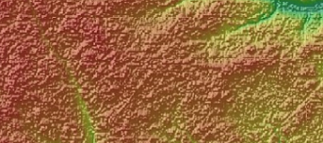
  • complexity of the terrain;
  • seasonality of work;
  • advance payment amount;
  • required computational power;
  • geological complexity of the site;
  • and others.

The cost of execution is calculated on an individual basis, taking into account a specific of task.

After receiving the task description, we calculate the cost and send you a commercial offer.

Period of execution

The completion time of the work is from 20 business days from the date of receiving the advance payment and is calculated individually for each customer.

The completion time of the work depends on:

- the total area of the territory of interest;

- requirements for the final product.

The service delivery time depends on the complexity of the work and is calculated individually for each customer.

How to place an order:

  1. STEP #1: Submit an application on the website with the following details:
    • Location of the object of research (coordinates);
    • Questions;
    • Dates for conducting the analysis.
  2. STEP #2: Agreement on technical specifications and cost:
    • Research starting from 1100 $;
  3. STEP #3: Contract signing and commencement of work:
    • Completion time is from 20 days from the date of receiving the advance payment - payment only through non-cash settlement.

Need for consultation?

Fill the form and we will contact you

By clicking the «Send» button, you give your consent to the processing of your personal data, in accordance with Federal Law No. 152-FZ of July 27, 2006 «On Personal Data», on the conditions and for the purposes specified in the Consent to the processing of personal data.

Stages of service provision

Stage #0 (BEFORE contract conclusion):

  • Receiving and coordinating data from the Customer. It is necessary to agree on the task that requires a solution, the size, nature of the area, and product creation requirements in order to calculate the cost and timeframe of the work.

RESULT: possibility (YES/NO) of providing the service

Stage #1 (BEFORE contract conclusion):

  • Agreement on technical specifications;
  • Final determination of labor and material costs, agreement on deadlines and costs.

RESULT: concluded contract

Stage #2 (Contract Execution):

  1. Conducting surveys in all available ranges of the electromagnetic spectrum, preliminary processing, and delivery of remote sensing data to the Customer's sites.
  2. Creation of geological maps.
  3. Construction of two (2D) and three-dimensional (3D) geological models.

RESULT: Delivery of materials to the Customer.

The result of the provision of services

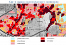
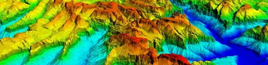
The Customer receives a geological map with a structural three-dimensional model.

Data of various types can be synthesized. The synthesis of available data significantly increases the accuracy and efficiency of modeling.

Geological map with a structural three-dimensional model
Figure 4: Geological map with a structural three-dimensional model


Requirements for Source Data

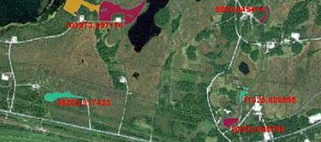
Accurate geographical coordinates of the object in the required coordinate system (specialists from GEO INNOTER LLC will clarify the coordinates provided by the Customer in any convenient form).

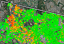
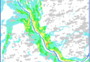
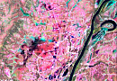
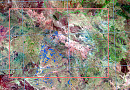
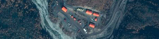
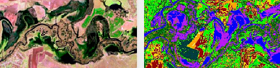
Sets of optical, IR (near and thermal), and radar images.

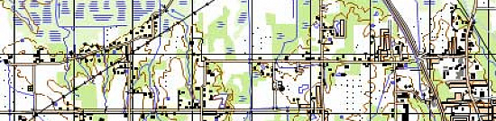
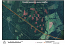
All available geological maps of the search area.

Software:

  • GIS - QGIS, ArcGIS, etc.
  • Processing - ERDAS, ENVI SARscape, SNAP, etc.
  • Modeling - Datamine Studio

Related services

Digital elevation models (DEM)
Find out the price
Orthoimagery (Orthorectification)
Find out the price
Satellite & UAV Monitoring
Find out the price
Remote sensing imagery Interpretation & spectral analysis
Find out the price
Digital Topographic Maps
Find out the price
Thematic mapping
Thematic mapping
Find out the price
Космический мониторинг территории
Find out the price
Создание ортофотопланов
Find out the price
Создание и обновление цифровых топографических карт
Find out the price
Составление тематических и специальных карт, планов
Find out the price
Дешифрирование данных дистанционного зондирования Земли (ДЗЗ)
Find out the price
Цифровые модели рельефа (ЦМР)
Find out the price
Zazulyak Evgeny Leonidovich
The material was checked by an expert
Zazulyak Evgeny Leonidovich
Engineer, 28 years of experience, Education - Moscow Topographic Polytechnic Technical School, St. Petersburg Higher Military Topographic Command School named after Army General A.I. Antonov, Military Engineering University named after V.V. Kuibyshev. Kuibyshev Military Engineering University.

Customers

Rosneft
Gazprom
Gazprom neft
Lukoil
Transneft

FAQ

Geological modeling (geomodelling) for rapid creation of reliable volumetric models and basic resource estimation includes the following components:

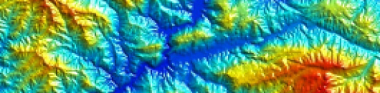
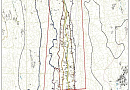
  • Wireframing of spatial bodies and surfaces. This involves a set of semi-automatic and interactive 3D tools for creating, modifying, displaying, and evaluating closed and topographic wireframe models.
  • Intelligent mineral exploration based on machine learning algorithms and 3D modeling.
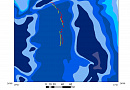
  • Geostatistical analysis of deposits includes tools for variogram construction, analysis, and interactive fitting of models. It also involves cross-validation of selected variogram models, multiple types of 3D kriging, resource estimation, and more.
  • Deposits modeling provides capabilities for constructing, viewing, evaluating, and editing block models of deposits. Metal grade interpolation and other indicators are performed using traditional and geostatistical methods. Visualization, interpretation, and modeling of project data (including Big Data) are also supported.
Accounting for the spatial position of the main boundaries of the geologic formation, including the effects of faulting, folding, and erosion. Therefore, the main rock stratigraphic lines are subdivided into layers of cells with different geometry with respect to bounding surfaces (parallel to the top, parallel to the base, proportional). The maximum size of rock cells is determined by the minimum size of rock composition objects to be resolved. Sometimes maximum resolution is required.
An important part of geological modeling (geomodelling) is related to geostatistics. To represent observed data, often not on a regular grid, we must use certain interpolation techniques. To reproduce more realistic spatial variability and to help estimate the spatial uncertainty between geologic data, geostatistical modeling based on variograms, training images, or parametric geologic objects is often used.
is associated with the concept of a comprehensive Earth model
Geological modeling involves creating three-dimensional representations of subsurface geological structures. Remote sensing data contributes to geomodeling by providing valuable information about surface geology, terrain characteristics, and environmental factors. This data aids in understanding the geological features that influence subsurface structures.
Remote sensing sensors like LIDAR capture high-resolution elevation data, assisting in geomodeling by providing accurate topographic information. Hyperspectral imaging captures a wide range of wavelengths, helping identify mineral compositions and geological variations. Both sensors find applications in geological mapping, structural analysis, and resource exploration.
Temporal analysis of remote sensing data is crucial in geological modeling for tracking changes over time. It helps monitor geological features, such as erosion, land subsidence, or vegetation growth, providing insights into dynamic processes influencing the landscape and subsurface structures.
Integrating remote sensing data with GIS technology enhances geological modeling by providing a spatial context for analysis. This integration supports decision-making in resource exploration and environmental management by allowing geologists to map and analyze geological features, plan exploration activities, and assess environmental impacts based on comprehensive geospatial information.
Geological modeling using remote sensing data benefits industries by improving resource exploration accuracy, optimizing mining operations, and assessing environmental risks. Challenges may include data interpretation complexities, calibration issues, and the need for ground validation to ensure the accuracy of geological models derived from remote sensing data.

Licenses

License for implementation of geodetic and cartographic activities (page 1)
License for implementation of geodetic and cartographic activities (page 2)
Application for the license for implementation of geodetic and cartographic activities
ISO 9001:2015 Certificate of Conformity №СДС.ФР.СМ.00813.19 (page 1)
ISO 9001:2015 Certificate of Conformity №СДС.ФР.СМ.00813.19 (page 2)

Warranty

We guarantee 100% quality of services. Cooperating with GEO Innoter specialists, you exclude risks and losses!

The availability of qualified personnel with extensive experience in working with specialized software allows us to ensure timely and high-quality work!

Our partners