Emergency Situation (ES) is a sudden or premeditated situation at a local, regional, or continental level of the Earth that poses a threat to humans or a specific area. It arises as a result of an accident, a hazardous natural phenomenon, a disaster, the spread of a disease dangerous to others, or another type of calamity. Such situations may lead to or have already caused human casualties, harm to public health or the environment, significant material losses, and disruptions to normal living conditions.
Emergency situations are classified based on their nature, scope, scale, and level of damage.
By origin:
- Natural;
- Technogenic (man-made);
- Environmental;
- Biological-social and medical.
By scope and nature:
- Of terrorist nature;
- Of humanitarian nature;
- Of natural origin;
- Of technogenic origin.
The integrated multi-level scheme for using remote sensing (RS) technologies and equipment allows for the effective resolution of most challenges arising in emergency situations.

Forecast: The global incident and emergency management industry is expected to reach USD 174.5 billion by 2027.

The statistical distribution of emergency situations and natural disasters indicates that the majority of incidents occur on land.
The emergency sector includes the field of emergency response services— a community of millions of highly skilled and trained personnel, along with physical and cyber resources that provide a wide range of services in prevention, preparedness, incident response, and recovery of daily life.

The development of aerospace technologies and services, with enhanced remote sensing (RS) and communication capabilities, has accelerated the widespread integration of spatiotemporal information into every phase of emergency management (mitigation, preparedness, response, and recovery).
Spatiotemporal information has become a critically important asset, offering tangible advantages for emergency services, necessitating the implementation of flexible and efficient spatiotemporal data management.


What Tasks Does Remote Sensing Solve:
- Situational awareness and operational needs require providing distributed spatial information in real-time, allowing emergency services to supplement existing geodata with additional details about the surrounding environment. Assessment of the condition of potentially hazardous objects and areas located in high-risk zones for emergencies. The core of emergency management systems is the GIS-Remote Sensing database.

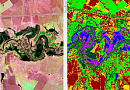
Fig.4 GIS-Remote Sensing Database - Mapping emergencies that support the crisis response phase, including natural disasters and humanitarian crises. For major types of natural disasters, suitable remote sensing imagery, corresponding technical specifications, and primary processing methods commonly used in emergency response structures.

Fig.5 Emergency Mapping - Infrastructure monitoring, real-time tracking of early warning signals, assessment of safe shelters, evaluation of emergency supply distribution, and determination of potential impacts on roads, bridges, and buildings.
- Remote sensing data is applied at all stages of disaster response, damage assessment, recovery, and mitigation of destruction consequences.
- Mitigation of large-scale floods and landslides. Creation of predictive models and environmental monitoring, especially using radar satellite and UAV LiDAR sensors. Synthetic aperture radar (SAR) images are widely used for flood mapping based on change detection approaches.
- Models for determining the optimal spatial distribution of emergency evacuation centers, such as schools, colleges, hospitals, fire stations, and government institutions. Creation of evacuation navigation tracks, alerts, and action recommendations for civilians.

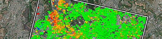
Fig.6 Evacuation Navigation Track Creation - Urban mapping, including 3D models of complex structures and hard-to-reach areas. Natural disasters significantly impact urban areas, causing loss of life and disrupting city services. Using satellite and aerial imagery, rapid and automated assessment of at-risk buildings can improve overall disaster management in urban environments.

Fig.7 Urban Mapping, 3D Models - Online spatially referenced video surveillance. Detection of individuals for emergency response services when searching for victims trapped under rubble after a disaster.
- Remote sensing analytical work for earthquake and volcanic eruption forecasting and mapping using satellite images, radar, and multispectral (hyperspectral) data. Damage assessment.

Fig.8 Remote Sensing Analytical Work for Earthquake and Volcano Eruption Forecasting and Mapping 
Fig.9 Damage Assessment - Geospatial assessment of the extent of oil spills and the dynamics of their spread.
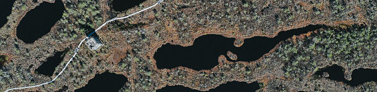
- Search for distressed objects in inaccessible locations and water areas. Identification of high-risk areas.

Fig.10 Risk Area Identification
Advantages of Using Remote Sensing:
- Easy access to data from remote areas
Since remote sensing analysis is performed in-office, fewer field studies are required, offsetting the cost of acquiring detailed disaster data. Comprehensive study of large territories using ground-based survey methods (such as tachymetry and leveling) requires enormous financial and time investments. Unlike remote sensing methods, ground-based studies struggle to achieve synchronicity and simultaneous observations across all sites.
- Ability to obtain images at different resolutions
Remote sensing data is utilized for emergency management in various tasks, from floods and wildfires (distributed data) to destroyed buildings (detailed data). One of the most important features of remote sensing methods is the ability to accumulate data over a large surface area in a short period, providing an almost instant snapshot.
- Objectivity of disaster situations
Satellite images objectively reflect the condition of an area at the moment of a disaster. The acquired image is not bound to political or administrative boundaries. No local government permission is required to obtain it. Many remote sensing data sets are commercially available, enabling the creation of disaster assessment models to transition more accurately to detailed analysis.
- GIS is a key element of disaster preparedness through computer modeling
A wide range of specialized software extensions for modeling is available. This allows users to configure disaster parameters and simulate damage models, such as those caused by natural disasters, pandemics, or wildfires. Developing spatial computational models for disaster consequences and using GIS for simulating hypothetical emergencies is essential for everyday emergency personnel training.
- Emergency warning capabilities
Some emergencies, such as hurricanes or severe storms, allow for preparation time, during which evacuation coordination and other preparatory activities (e.g., reinforcing dams with sandbags) are implemented as a response to the approaching event. Remote sensing methods enable near real-time monitoring of evolving situations.
- Disaster impact assessment
Remote sensing methods have demonstrated great potential in localizing the most damaged regions, thus guiding aid and rescue operations, such as during earthquakes. To minimize earthquake casualties, it is necessary to immediately identify heavily damaged, unsafe buildings. The potential of response spectrum concepts combined with satellite remote sensing data for assessing structural damage after an earthquake is significant.
Examples of Applications:
Flood Hazard Maps
Near real-time remote sensing data on flood extents can be used for emergency flood management and as observations for assimilation into flood forecasting models.
TASK: Identifying the extent of urban flooding.
SOLUTION: High-resolution synthetic aperture radar (SAR) sensors have the potential to address this task. The method for detecting floods in urban areas combines SAR data on real-time flood extents with flood hazard maps derived from LiDAR surveys.
RESULT: This approach creates a two-way synergy where current urban flood extent data from SAR improves future flood forecasts, while flood hazard maps generated after SAR acquisition enhance SAR-based urban flood assessment. Simultaneously, SAR-based flood assessment in rural areas adjacent to urban regions has been evaluated. A method utilizing SAR exclusively in rural areas yielded an average flood detection accuracy of 94% and a false alarm rate of 9% in urban regions, outperforming existing ground-based methods.

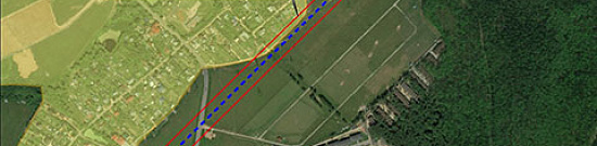
The agreement between flood extents from the Flood Foresight model (combined with SAR-based urban flood mapping) and aerial imagery of flood extents in urban and rural areas of Tewkesbury, overlaid on a LiDAR image of the urban area (lighter gray indicates higher elevation), and (b) the agreement between flood extents from the Flood Foresight model and aerial imagery of flood extent along a 6-km rural stretch of the Severn River northwest of Tewkesbury (Mythe Bridge, visible in (b), is located to the northwest of (a)).
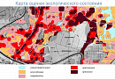
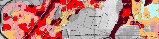
Risk & Recovery Mapping (RRM)
Risk and recovery mapping for disasters involves providing maps (and disaster analyses) over weeks or months to support activities related to recovery, reconstruction, risk reduction, preparedness, and disaster prevention.
TASK: Accurate information on various hazard types, risks to people and buildings, their exposure, vulnerability, and resilience.
SOLUTION: Mapping disaster-affected (or potentially affected) areas using remote sensing.
RESULT: By comparing images taken at different times, quantitative and qualitative assessments of terrain changes were conducted. Pre-disaster terrain mapping provides up-to-date thematic information that can help emergency response services and civil defense in planning actions for disaster-prone areas.

")
MAP OBJECTIVE: To assist planners, architects, and decision-makers involved in humanitarian aid planning and civil defense in disaster risk reduction activities.
Unmanned Aerial Vehicles (UAV) for Wildfire Monitoring
Advances in autonomous technology and microelectronics have increased the use of UAVs for wildfire monitoring and firefighting. This method is a cutting-edge tool for emergency response teams.
TASK: Developing a fire monitoring system based on UAV-implemented algorithms.
SOLUTION: UAVs equipped with RGB and thermal cameras, temperature sensors, and communication modules provide comprehensive information about the fire and the UAV itself, transmitting this data to a receiving station in real time.
RESULT: The wildfire monitoring task was successfully implemented, allowing surveillance of specific areas. Algorithms for autonomous takeoff/landing, trajectory planning, and fire monitoring were developed. The results demonstrate the system’s effectiveness and resilience under various weather conditions.

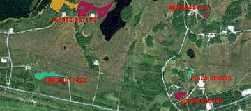
Local-Scale Wildfire Risk Mapping – Example from Andalusia (Spain)
Wildfires pose a serious environmental challenge for modern societies, with significant consequences for ecological, economic, and personal safety.
TASK: Creating detailed maps to identify areas at risk, which is a crucial first step in implementing various fire prevention and protection measures. These maps are particularly valuable for land management and municipal-scale emergency planning.
SOLUTION: A methodology for generating local-scale wildfire hazard maps considering both natural and human factors. Among natural factors, variables commonly used in hazard models include fuel types, slopes, and vegetation moisture levels.
RESULT: New aspects of anthropogenic wildfire hazard assessment (proximity to ignition sources or human accessibility to forest environments) were evaluated, and vulnerability assessments were conducted, considering population distribution in urban centers and dispersed settlements.
The methodology was applied in a municipality in Andalusia (Spain), and the obtained results were compared with burned area maps.
 January 14, 2013. (B) July 25, 2013.")
")
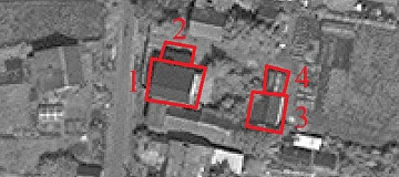
Development of Remote Sensing Interpretation Algorithms for Disaster Mapping
Rapid disaster mapping using various types of satellite imagery is a challenging task. The faster data is received, the more timely the information available for decision-making. However, data delivery speed should not compromise information quality.
TASK: Automated extraction of data on floods and wildfires.
SOLUTION: Mapping pipelines allow the full utilization of advanced algorithms within short timeframes, leaving enough time for expert operators to verify results and correct any thematic errors. While automated algorithms are not flawless, they significantly facilitate and accelerate crisis information detection and mapping, particularly for floods and wildfires.
RESULT: A system of algorithms for disaster mapping was developed. This system integrates automatic data acquisition and preprocessing, as well as high-precision flood and wildfire detection chains.

Several settlements along the Amur River in Russia’s Jewish Autonomous Region were flooded, affecting about 32 villages and surrounding areas. Ivanovka was one of the most severely affected. The water level in the Right Urkan River reached 810 cm, prompting the evacuation of affected residents.

More than 260 mm of rain fell on the city of Petropolis, causing torrential rains. Located on the slopes of the Flumanes Mountains, the city was swept away by floods and mud, destroying houses and covering the streets with mud and debris.
Need for consultation?
Fill the form and we will contact you
Related services

Customers


FAQ
Emergencies (EM) are extraordinary events that arise due to natural or man-made processes, as well as human actions. They can result in casualties, significant material and environmental damage, and the creation of hazardous zones.
In recent years, Russia has experienced numerous emergencies caused by various factors, such as floods, fires, accidents at hazardous facilities, terrorist attacks, and others. These incidents vary in nature and can have large-scale consequences.
To combat emergencies, Russia has a system for emergency prevention and response, which consists of multiple levels. At the federal level, the Ministry of Emergency Situations (EMERCOM) and Roshydromet monitor the situation in real-time and warn the public about potential threats.
In the event of an emergency, regional authorities must take measures to mitigate the consequences and protect the population. Various organizations and agencies, such as firefighters, medical personnel, rescuers, police, and others, are involved in these efforts.
Additionally, emergencies are classified by type and scale, which helps determine the extent of consequences and the necessary response measures. Environmental protection measures are also implemented to prevent pollution and safeguard public health.
It is important to note that emergencies are unpredictable events, and not all of them can be prevented. However, proper emergency response can significantly reduce damage and save lives.
Some examples of emergencies:
- Natural disasters such as earthquakes, floods, hurricanes, tornadoes, and wildfires.
- Technological accidents, including industrial explosions, nuclear plant incidents, or oil platform accidents.
- Epidemics and pandemics, such as COVID-19.
- Terrorist attacks, including assaults on public places or transportation.
- Wars and conflicts, including civil wars.
- Mass riots and civil unrest.
In each case, it is crucial to have an action plan and prepare for emergencies to minimize the risk of negative consequences and ensure the safety of people and property.
Various emergencies occur in Russia, which can be caused by natural disasters, technological accidents, epidemics, and other factors. Some examples of such situations include:
- Natural disasters such as earthquakes, floods, wildfires, and tornadoes. In 2021, Russia experienced large-scale wildfires that affected multiple regions of the country, including Siberia, the Urals, and the Far East.
- In 2018, a major earthquake struck the Kamchatka region.
- Technological accidents, such as nuclear power plant incidents or transportation accidents. In 1986, the Chernobyl Nuclear Power Plant disaster became the largest nuclear catastrophe in history, causing severe consequences for human health and the environment.
- Epidemics and pandemics. In 2020, Russia declared the COVID-19 pandemic, leading to significant changes in people's lives and the country's economy.
- Major industrial accidents. In 2020, an accident occurred at the Norilsk Thermal Power Plant-3 in Krasnoyarsk Krai, resulting in a massive fuel spill into a river.
- On September 15, 2022, the aftermath of the powerful Typhoon "Hinnamnor" in Primorsky Krai was officially recognized as a federal-level emergency. The typhoon, which hit the region on the evening of September 4, caused heavy rains that flooded 991 homes, 1,072 household plots, and damaged 34 bridges. Three people lost their lives due to the disaster. According to preliminary estimates, the damage caused by the storm exceeded three billion rubles.
The classification of emergencies (EM) is an important tool for determining the scale and level of danger of emerging events, as well as for developing necessary measures for their mitigation and population protection.
In Russia, there are several types of emergency classifications. Let’s consider some of them:
- By scale and level of danger:
- Local-level emergencies – occur within a specific settlement or facility and have a localized nature.
- Regional-level emergencies – take place within a region and may affect multiple settlements.
- Federal-level emergencies – arise across multiple regions or the entire country, representing large-scale events that can have a significant impact on the economy and society.
- By causes of occurrence:
- Natural emergencies – occur due to natural disasters such as earthquakes, floods, tsunamis, etc.
- Technological emergencies – caused by industrial processes and accidents at hazardous facilities, such as nuclear power plant incidents, oil platform accidents, etc.
- Social emergencies – related to human factors, such as terrorist attacks, mass riots, etc.
- By level of danger to the population and the environment:
- Category 1 emergencies – pose a direct threat to life and health and cause significant environmental damage.
- Category 2 emergencies – present a certain level of threat to human life and health and may also cause environmental harm.
- Category 3 emergencies – do not pose an immediate threat to human life and health but may result in economic, industrial, or environmental damage.
The second classification method is based on the nature of emergencies. In this case, emergencies are divided into natural and technological.
Natural emergencies arise due to natural phenomena such as earthquakes, floods, tsunamis, wildfires, and others. Technological emergencies are related to human activities and occur as a result of industrial accidents, transportation incidents, technological disasters, and other similar events.
The third classification of emergencies is based on the level of danger they pose to people and the environment. Emergencies can be divided into two groups: hazardous and non-hazardous. Hazardous emergencies can cause severe harm to human health, life, the environment, property, and infrastructure, whereas non-hazardous emergencies have less severe consequences.
The classification of emergencies is essential for determining response strategies and tactics, as well as for implementing necessary measures to prevent their occurrence. In Russia, emergency classification is an integral part of the civil defense system and planning efforts to protect the population and infrastructure in extreme situations.
Emergencies (EM) can arise due to various causes, including natural phenomena. The classification of emergencies by their origin includes the following types:
-
Fires. These can include forest fires, peat fires, industrial fires, or fires in residential or public buildings.
-
Floods. Water-related disasters can be caused by heavy rainfall, rivers, glaciers, or tsunamis. As a result, people, settlements, and infrastructure may be affected.
-
Earthquakes. This natural phenomenon causes ground vibrations, which can lead to the destruction of buildings, roads, and bridges, as well as injuries and loss of life.
-
Cyclones and hurricanes. These are powerful wind phenomena that may be accompanied by heavy rainfall, floods, and other types of natural disasters. They can cause significant damage to cities, seaports, and other infrastructure.
-
Natural disasters. These include various natural phenomena such as droughts, landslides, mudflows, tornadoes, hailstorms, avalanches, and others. They can cause destruction and pose a threat to human life and health.
The classification of emergencies (EM) by scale is a system for categorizing emergencies based on their impact on people, property, the environment, and public infrastructure. The classification by scale includes the following types of emergencies:
-
Local-level emergencies – these are emergencies confined to the territory of a municipal entity or part of a city and affect a relatively small number of people and properties.
-
Regional emergencies – these affect multiple municipalities within a single region or part of a region. They can impact a larger number of people and properties.
-
Federal-level emergencies – these emergencies cover multiple regions or the entire country. They can have severe consequences for human life and health, infrastructure, the environment, and the economy.
-
International emergencies – these emergencies span multiple countries. Examples include global disease outbreaks or disasters affecting several nations.
The classification of emergencies by scale helps assess potential threats and determine necessary precautionary measures to protect people and property depending on the scale of a possible disaster. It also allows for defining the scope of emergency response operations and coordinating actions between relevant authorities and emergency services.
Licenses


Our partners


")


")

Sat-Sun: Non-working days