



Orthophotomaps with source images, vector thematic processing and a technical report on the MDZ and protection-zone violations.
Search the site
What the service is used for
Safe operation of hazardous facilities
Ensuring safe operation of especially hazardous facilities and adjacent territories.
MDZ and the real-estate register
Determination of the MDZ, including boundaries, and entry into the Unified State Register of Real Estate.
Illegal construction
Identification of existing and under-construction buildings and structures, including illegally built ones, in MDZ and protection-zone territories.
Vegetation and rights-of-way
Identification of tree and shrub vegetation, control of right-of-way width versus the protection zone, logging residues.
Pipeline condition
Damage to berms and backfill, off-design position, pipe exposure at the surface, unauthorised works and crossings, spills and leaks.
Did not find your task?
Send the object coordinates, survey period and MDZ accuracy requirements. A specialist will assess the archive and the scope of work.
What you will receive as monitoring results
01
Orthophotomaps and source imagery
Orthophotomaps (orthomosaics) together with source remote sensing images.
The geospatial base is built from orthorectified images of very high spatial resolution (down to 1 m at nadir).
What you get
- orthophotomaps / orthomosaics
- source satellite or aerial images
- a basis for measuring distances to objects in the MDZ
The survey composition and parameters are fixed in the terms of reference. Archive availability depends on the territory and period.
02
Thematic processing in vector formats
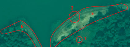
Thematic processing materials: MDZ boundaries, surrounding objects and identified violations.
After the base is prepared, specialists analyse objects falling into the MDZ and enter violating sections into the geospatial database.
What you get
- vector layers of thematic processing
- linear coordinates and length of HPF pipeline sections with MDZ violations
- shortest distances to violating objects and a list of them
The list of layers and object classification depend on the terms of reference.
03
Technical report
Technical report on the processing of remote sensing materials.
The report records quantitative assessments, identified violations and the customer's original requirements.
What you get
- technical report
- results of quantitative assessments
- data for risk analysis and ranking of hazardous sections
The report scope is defined by the contract and the terms of reference.
04
Geospatial database of violations
End product for risk analysis: HPF trunk-pipeline sections with MDZ violations in a geospatial database.
Spatial data are stored separately and used to rank hazardous sections and for further processing.
What you get
- sections with MDZ violations
- linear coordinates, length and a list of violators
- a basis for GIS management of MDZ geospace
The database format and attribute set are agreed in the contract.
How the work goes
Cost and timeline
The cost depends on the area, requirements for remote sensing materials and the scope of thematic processing. The timeline is counted from the advance-payment date.
- consultation — free of charge
- preliminary analysis — free of charge
- order of remote sensing materials — calculated individually, minimum cost from 6$ per 1 km²
- work of technical specialists and expert(s) — from 50 000 rubles
- total cost — from 50 000 rubles
- work execution timeline — from 10 working days from the advance-payment date; depends on the total area, requirements for remote sensing materials and the end product
- minimum work execution period — from 10 (ten) working days (FAQ)
- in the order steps: timeline from 10 days from receipt of a 50% advance, payment by bank transfer only, remaining payment after delivery of materials and signing of acts
- in the FAQ: 100% prepayment on the invoice for remote sensing materials after signing the contract, remaining payment after the work is done
- at the contract execution stage: receipt of a 50% advance to order and purchase remote sensing materials
Order cost — from 50 000 rubles
Turnaround — from 10 working days
Consultation and preliminary analysis — free of charge
What data is needed for a quote
To assess the archive or a new survey and the cost of MDZ monitoring, please provide:
- location of the object of interest (coordinates, district/region name, shapefile)
- survey period requirements (archival data or a new survey)
- accuracy of determining the minimum distance zone
- deadlines for delivery of finished materials
- exact coordinates of the area of interest, requirements for remote sensing materials (ground resolution, survey type, off-nadir angles, minimum sun angle, survey period)
- full requirements for thematic processing and output data formats
If the exact parameters are unknown, describe the task and object — specialists will assess survey feasibility and the processing scope.
Describe the task in simple terms — we will check the archive and the feasibility of a new survey.
Why Innoter
Prompt access to archives
Suitable archive imagery can be obtained faster when the required area and date are already available from operators.
No aviation clearances
A new satellite survey does not require the flight clearances typical of aerial surveys.
Large and remote areas
A single satellite pass covers large areas and makes it possible to work in hard-to-reach regions.
Direct agreements with operators
Distributor agreements help select archival imagery and order new surveys from different suppliers.
Software and server infrastructure
Modern software and computing capacity for quality control and processing of large data volumes.
Experienced specialist team
Many years of experience in complex projects and specialists in cartography, photogrammetry and remote sensing.
MDZ, survey, power lines and regulatory zones
The composition depends on the object type, archive or new survey, boundary accuracy and thematic processing requirements.
1
Minimum distance zone (MDZ) monitoring is monitoring of territories or water areas within boundaries defined by the minimum allowable distance from the axis of trunk pipelines (gas pipelines, oil pipelines, product pipelines, etc.), power lines and railways, within which certain objects may be located; the boundaries are calculated by processing aerospace materials.
Monitoring of protection-zone and minimum-allowable-distance-zone violations of hazardous facilities is carried out to comply with legislation on the safe operation of especially hazardous facilities and adjacent territories.
2
Pipeline monitoring (infrastructure control) is performed by a combined remote sensing method: satellite imagery and UAV survey in daytime and at night.
Prompt detection: failures on oil-field pipelines; spills of oil, oil products and produced water; unauthorised taps and third-party actions; fires in forests and peatlands along pipeline routes; litter along the right-of-way; unauthorised storage of construction materials and pipes; unauthorised persons and vehicles in protection zones.
Condition assessment: aerial crossings and crossings of water barriers and ravines; valve assemblies, pig launcher and receiver units; along-route roads, bridges, crossings, culverts; off-design position of sections; repair works; kilometre posts and signs.
Control: violations and damage; sites of construction and installation works and earthworks; crossings and parking of machinery without documents agreed with the operator.
3
Automatic monitoring of power lines and the MDZ is automatic inspection of power lines from satellite and UAV images: line measurement, 3D reconstruction of the terrain along the corridor (MDZ) and obstacle recognition.
Machine-learning methods make it possible to track asset reliability and automatically detect overgrown vegetation, illegal construction in the right-of-way and natural-hazard events (landslides and floods).
The source separately notes: vegetation detection in power-line corridors from optics, SAR and LiDAR; new visualisation methods, including UAVs and autonomous vehicles; detection of hazardous conditions around critical assets.
4
Monitoring is carried out on a geospatial base from orthorectified images of very high spatial resolution (down to 1 m at nadir).
First, source data are collected: the area of interest, terms of reference, selection of archival satellite imagery or an order for a new survey. Then photogrammetrists process the images and prepare the base. Specialists analyse surrounding objects that fall into the MDZ. At the final stage they perform geoprocessing, quantitative assessments and enter into the database HPF trunk-pipeline sections with MDZ violations, linear coordinates, length and shortest distances to violators.
5
For power lines the source lists: detection of vegetation and its height; inspection of towers; search for breaks and damage assessment; data for prompt emergency response. Automatic detection of vegetation in the power-line protection zone, measurement of vegetation height, detection of damaged towers and broken wires.
The protection zone of highways in the Russian Federation is described in the source as having a vague value and ranging from 25 to 50 metres, and even less when passing through settlements. For railways the FAQ gives examples: at least 50 m to roads, parking lots, warehouses, public utilities and garden plots; at least 100 m — a fence, house, garage. Actual protection territories depend on location, number of tracks, route parameters and power-line voltage.
6
The remote sensing method is faster than field work, more convenient in complex natural-climatic and geological conditions, more effective for long and hard-to-reach hazardous facilities (trunk pipelines, power lines) and more acceptable in price/quality ratio.
Early detection reduces the risk of fines and fire-hazard situations with damage to property or a threat to life. According to the source, some sections of especially hazardous facilities fall into a high-risk group of man-made accident (with MDZ violation).
For roads the source also lists: a continuously operating MDZ GIS; environmental conditions on thematic maps; emissions and noise; recording of littering and illegal construction; NDVI and NDMI in MDZ buffers. For railways: the NDReLI index for corridor erosion, monitoring of landslides, ballast without vegetation, construction and reconstruction of infrastructure.





Frequently asked questions
Answers to key questions about service parameters, timelines, deliverable formats and workflow. If you did not find what you need — contact us and we will help.
The question is not an idle one, as it determines the practice of remote sensing in aerial planning (UAV) or satellite imagery.
However, in reality, there are certain discrepancies in the concept of the protection area due to the location, the number of railroad or highway infrastructure tracks, the specifics of the pipeline route, the height and magnitude of the transmission voltage of the power lines, and, in general, the need to prevent potential risks.
The protection zone of, for example, railroad tracks and highways, in any designation used in regulatory documents, is nothing but necessary precautions. They are taken for the problem-free parallel existence of specific railway and highway transportation, structures and buildings for its functioning with other buildings and areas, surrounding vegetation, natural and geophysical hazards.
Example, Distance from railroads :
Not less than 50 m - highways, parking lots, warehouses and public utility establishments, garden plots ;
at least 100 m - fence, house, garage.
The terms of work execution depend on the area of the territory, requirements to the survey parameters.
The minimum period of work execution is from 10 (ten) working days
The minimum period of work execution is from 10 (ten) working days
100% prepayment on the invoice for remote sensing materials after signing the contract, the rest of the payment after the work is done.
- location of the object of interest (coordinates, name of the area, region, shp-file, etc.);
- survey period requirements (period for which archive data can be used or a new survey is required);.
Infrastructure Change Detection for gas main pipelines is part of the provision established by law in the Russian Federation that regulates the establishment of safety boundaries for the construction and operation of gas pipelines.
Compliance with the established rules and conditions is ensured through governmental control and regulation of organizations involved in the industrial use of gas.
The zone of minimum distances of gas main pipelines is determined based on information on soil characteristics, gas pressure, gas pipeline diameter and other factors specified in federal level documents. The established procedure for amending these documents must also be observed.
According to Russian legislation, the zone of minimum distances of gas trunk pipelines must be determined on a case-by-case basis, based on the specific conditions of construction and construction of facilities.
A separate paragraph of the rules stipulates that in the zone of minimum distances of gas trunk pipelines any kind of construction and other ground works that may cause damage to the gas pipelines must be prohibited. This is to ensure the safety of gas pipelines and prevent possible accidents.
Thus, theInfrastructure Change Detection of Gas Trunklines plays an important role in ensuring the safety of industrial facilities and land in Russia.
A gas main Infrastructure Change Detectionis a safety zone that defines the minimum distance from the gas main line within which any construction or other ground work that could damage the pipeline is prohibited.
Federal regulations controlling the zone of minimum distances of gas main pipelines are part of the legislation of the Russian Federation establishing rules for construction and operation of gas pipelines.
The main rules are:
In addition, the federal rules establish requirements for control and monitoring of the condition of gas pipelines in the minimum distance zone, as well as for emergency and preventive measures.
Compliance with these rules is controlled by the relevant state control authorities, and administrative and criminal penalties are envisaged for their violation.
The main rules are:
- Russian Government Resolution No. 861 of December 30, 2004, "On Approval of the Rules for Establishing the Boundaries of Safety Zones of Linear Energy and Transport Facilities";
- Federal Law No. 383-FZ dated December 21, 2013 "On Energy Saving and Increasing Energy Efficiency and on Amendments to Certain Legislative Acts of the Russian Federation".
In addition, the federal rules establish requirements for control and monitoring of the condition of gas pipelines in the minimum distance zone, as well as for emergency and preventive measures.
Compliance with these rules is controlled by the relevant state control authorities, and administrative and criminal penalties are envisaged for their violation.
The legislation of the Russian Federation contains a number of regulatory acts that regulate the issues of control over the minimum distance zone of gas main pipelines.
One of such acts is Federal Law No. 190-FZ dated July 27, 2010 "On Gas Supply in the Russian Federation", which establishes requirements for construction and operation of gas pipelines, including the minimum distance zone.
According to this law, the construction and operation of gas pipelines must comply with the established safety and environmental protection requirements, as well as ensure efficient utilization of energy resources.
- Federal Law "On Gas Supply in the Russian Federation" - defines the legal framework for the construction, operation and safety of gas pipelines in Russia, including minimum distances and requirements for compliance.
- Federal Gas Supply Rules and Regulations - defines detailed requirements for gas pipelines, including minimum distances to facilities and buildings.
- Technical Documentation Standards - defines requirements for the design and construction of gas pipelines, including minimum distance zones.
- Agreements and licenses for gas pipelines operation - contain information on requirements for gas pipelines operation and compliance with minimum distances.
- Technical documentation for gas pipelines - includes information on distances to facilities and buildings and safety measures.
- Inspection and verification reports and protocols - contains information on the results of inspections of compliance with minimum distances and safety measures.
- Maps and diagrams of gas pipelines - includes information on the location of gas pipelines and minimum distances.
When using RS (remote sensing) and GIS (geographic information systems) to analyze the zone of minimum distances, the following documents can be provided to the customer:
Depending on the terms of the contract between the customer and the RS/GIS provider, other documents and materials may be provided, such as reference books on technical parameters of gas pipelines and facilities, standards and regulations used in the analysis of minimum distance zones, etc.
- Remote sensing maps and images, which allow to estimate the distance between gas pipelines and other objects such as buildings, roads, power lines, etc.
- Analysis reports that provide information on compliance with minimum distances and possible violations, as well as recommendations for safety measures.
- Electronic maps and databases created in GIS, which may contain information on gas pipelines, minimum distance zones, facilities, and other important parameters.
- Graphical and textual materials that can be used for risk assessment and pipeline management decisions.
Depending on the terms of the contract between the customer and the RS/GIS provider, other documents and materials may be provided, such as reference books on technical parameters of gas pipelines and facilities, standards and regulations used in the analysis of minimum distance zones, etc.
The gas trunkline Infrastructure Change Detection is the area established by regulations that covers the territory in which construction and location of facilities must comply with certain requirements established by law and regulations. This zone covers the distance from main gas pipelines to settlements, industrial and agricultural facilities.
The distance established for the minimum distance zone is determined on the basis of various regulatory documents. Such documents include SNiP, rules and instructions of ministries and agencies, the Urban Planning Code and others. For example, Order of the Ministry of Fuel and Energy of the Russian Federation No. 176 of March 23, 2016, "On Approval of the Rules for the Location of Trunk Gas Pipelines and Oil Product Pipelines on the Land of Settlements" sets forth the requirements for the distance from gas pipelines to settlements and other objects.
This order also states that the zone of minimum distances for gas pipelines should provide for the distance established in accordance with SNiP 2.05.06-85 "Gas Distribution Systems". The grounds for establishing the zone of minimum distances can also be determined on the basis of other sets of normative documents.
The zone of minimum distances of the main gas pipeline shall be established in accordance with the legislation and regulations, exceptions may only be cases when the owner of the land plot or the enterprise can ensure safe operation of the gas pipeline. In such cases it is allowed to reduce the distance to the minimum value.
Agricultural facilities located in the zone of minimum distances are also subject to relevant requirements and restrictions. In particular, the requirements for the location of agricultural facilities in accordance with the Town Planning Code and other regulations must be complied with

Need satellite imagery or help choosing the right data?
Describe your task, area of interest, and desired outcome. We will check data
availability, assess new acquisition options, and propose the optimal solution in terms of timelines, cost,
and quality.
Discuss the project
clients who trust us
25+ years in the geodata market







