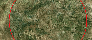
The concentration of gold deposits exploration is of interest to mining companies. Gold deposit exploration is carried out using modern technological solutions: remote geological exploration of a specific area allows for precise determination of the location of gold ore deposits, thereby minimizing the financial resources allocated for prospecting and extracting valuable metals.
Searching for Gold Ore Deposits Using Specialized Software
Assessing a gold ore deposit is a specific research task that can only be performed by engineers with specialized expertise. The team's tasks include improving forecasting quality, testing RGE (remote geological exploration) methods to locate gold-bearing ore.
Positive aspects of ore deposit exploration using modern technologies:
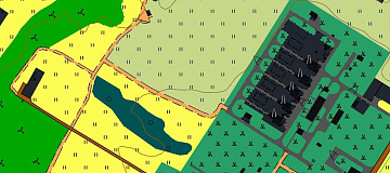
- Classification of various landscape communities based on specific parameters;
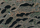
- Creation of a stream distribution scheme using radar imaging;
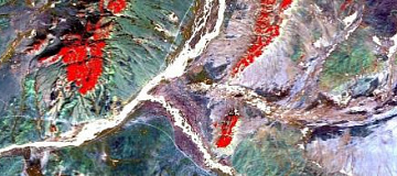
- Obtaining composite images of surveyed areas after arithmetic manipulations with spectral channels;
- Creating geological images of areas to establish connections with contemporary geological structures;
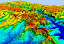
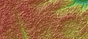
- Generating three-dimensional representations of the relief of the surveyed area (in digital form), with future satellite imagery;
- Identification of gradient zones related to geological boundaries, topography, vegetation;
- Delineation of ore bodies (Gold resource assessment).
Identifying prospective ore-bearing areas positively impacts the productivity of mining companies, increases enterprise profitability, and reduces expenses on leased and serviced equipment and machinery. Ready-made projects are available for a rough understanding of the advantages of the technologies used.
Work Conducted by Specialists in Gold Resource Assessment
Gold ore deposit exploration includes the selection of archival materials from satellite imagery, compilation of cartograms, analysis of the interpretation of collected materials, processing of satellite images, formation of a GIS project, and more. The search for a gold ore deposit involves a series of technological stages and represents a significant volume of specialized work.
Modern gold exploration work includes the following activities:
- Preparation of digital models of specific terrain;
- Planning of elevation tie points;
- Elevation tie points;
- Establishment of working coordinate systems;
- Gold ore exploration;
- Identification of ore;
- Identification of control points in space imagery;
- Creation of anaglyphic images of the terrain model;
- Alignment of blocks in space imagery;
- Implementation of orthorectified images.
Sequential ore zone exploration is a responsible task, the outcome of which directly affects the cost of industrial extraction of valuable metals. Multispectral imaging materials with medium spatial resolution are used in the process. With the help of this data, ortho-photoplans are created in the required scale.
What Is Delivered to the Client as a Result of the Research
Accurate exploration of a gold ore deposit helps determine the locations of gold ore with high probability. Engineers compile a space-structural scheme with the positions of linear and basic focal structures marked on it based on the exploration results. The search and exploration of alluvial deposits are significantly simplified and cost-effective due to the data collected during the research. The scheme includes areas of abnormal tonal change. Identifying gold ore zones using the latest technological advancements is a profitable tool for the specialized business.


Prices for services
| Consultation | Free |
|---|---|
| Image Selection, Preliminary Analysis, Technical Task Compilation | Free |
| Image Ordering |
The cost of remote sensing materials (RSM) is calculated individually for each order and may vary: - Using free satellite images - and/or using commercial satellite images* |
| Work of Technical Specialists and Expert(s) | From $10,000 USD |
| TOTAL COST | From $10,000 USD |
* - if the Customer does not provide their materials, or it is not possible to use free images.
The cost depends on:
- Area of interest (region);
- Type of imaging - archival / new, free images / paid;
- Number of images;
- Quality characteristics of the images;
- Complexity of the terrain;
- Seasonality;
- Advance payment amount;
- Required computational resources;
- Geological complexity of the area;
- Whether materials need to be purchased or provided by the Customer;
- And more.
The cost of execution is calculated on an individual basis, taking into account a specific of task.
After receiving the task description, we calculate the cost and send you a commercial offer.
Period of execution
The timeframe for conducting reconnaissance of mineral deposit locations is a minimum of 20 working days from the date of receiving the advance payment and is calculated individually for each customer.
The service completion timeframe depends on:
- Total area of the area of interest;
- Availability of archival remote sensing materials (RSM), the need for new imaging;
- Requirements for remote sensing materials (RSM), the final product.
The service completion timeframe depends on the complexity of the task and is calculated individually for each customer.
How to place an order:
- STEP #1: Submit an application on the website, specifying:
- Location of the research object (coordinates);
- Questions;
- Dates for which the analysis is required.
- STEP #2: Agreement on the technical task and cost:
- Research starting from $10,000 USD;
- Images are paid for separately.
- STEP #3: Signing the contract and commencing the work:
- Timeframe of at least 20 working days from the date of receiving the advance payment - payment is accepted only via bank transfer

- Timeframe of at least 20 working days from the date of receiving the advance payment - payment is accepted only via bank transfer
Need for consultation?
Fill the form and we will contact you
Stages of service provision
-
Stage #0 (Before Contract Signing):
- Receipt and Coordination of Information from the Customer. It is necessary to coordinate the task requiring a solution, size, terrain characteristics, and product creation requirements to calculate the cost and timeline for the services.
RESULT: Possibility (YES/NO) of providing the service
-
Stage #1 (Before Contract Signing):
- Agreement on the technical task
- Collection, systematization, and initial analysis of remote sensing data (Terra / Aster, Landsat / ETM+, Hyperspectral, Hyperscan, SWIR, etc.);
- Planning of Imaging. The best imaging geometry is calculated after a complete informational geological analysis of the territory for exploration, taking into account the available archive of remote sensing data (RSDD).
- Collection for creating a vector topographic map with a search area at a scale of 1:10,000 – 1:50,000.
- Final determination of labor and material costs, agreement on timelines and costs
RESULT: Signed contract
-
Stage #2 (Contract Execution):
- Conducting imaging in all available electromagnetic spectrum ranges, preliminary processing, and delivery of remote sensing data to the Customer's sites.
- Analysis of materials to build structural geological models of minerals and create a spectral signature database for accompanying rocks and areas of Customer interest.
- Selection of a reference library of spectra of minerals and rock formations near ore-related changes in known deposits/occurrences, selection of the most informative indicator minerals.
- Processing of available geological information to create comparative standards.
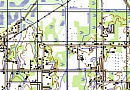
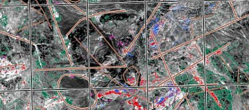
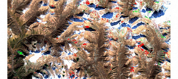
- Creation of mineral indicator schemes at scales of 1:50,000, 1:25,000, and 1:10,000.
- Creation of complex anomaly maps created on the analogy principle with reference objects.
- Creation of prospecting geological maps.
- Compilation of a report containing explanatory text for the created cartographic materials and recommendations for selecting prospective areas for field verification.
Geoinnoter applies spectral and sub-pixel analysis methods (but not limited to):
- Principal Component Analysis (PCA);
- Spectral Angle Mapper (SAM);
- Minimum Noise Fraction Transform;
- Pixel Purity Index;
- Multi-range spectral feature fitting (Multi-Range SFF);
- Structural decoding;
- Calculation of mineralogical indices;
- And others.
RESULT: Delivery of materials to the Customer
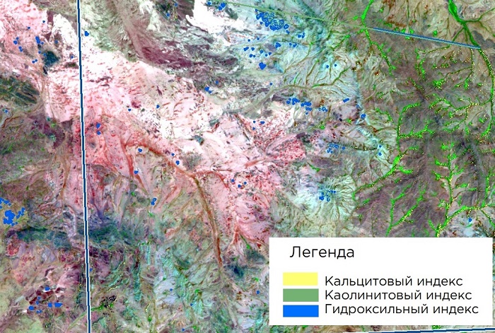
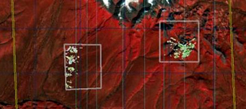
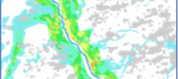
Fig. Example of mineral indicator scheme, decoding of KS Aster
Related services


Completed projects
Customers


FAQ
Licenses


Warranty
We guarantee compliance with building codes (SNIP), state standards (GOST), and construction regulations (SP). We adhere to advanced methodologies and utilize the most up-to-date software tools.
We ensure a 100% quality guarantee for our services. By collaborating with GEO Innoter specialists, you eliminate risks and losses.
The presence of qualified professionals who are proficient in specialized software and possess years of experience enables us to provide these assurances!
Our partners


")


")

Articles


Sat-Sun: Non-working days