Orthoimagery, also known as orthophotography, refers to aerial or satellite images that have been geometrically corrected (orthorectified) to ensure uniform scale and true geographic representation. These images are corrected for distortions caused by the camera angle, lens curvature, and topographic relief, making them accurate for use in mapping and spatial analysis.

Orthoimagery (Orthorectification) is a image of the terrain in an orthogonal projection, defined by a coordinate system and a desired scale. It is obtained by orthorectifying aerial or satellite images using control points, ground control points (GCPs), or rational polynomial coefficients (RPCs) to remove distortions caused by image acquisition conditions, camera equipment, image tilt angles, and terrain relief. The orthorectified images are then stitched together and cut into orthophotoplanes based on predefined or custom sheets. An orthophotoplan captures detailed information about the real-world features on the Earth's surface.


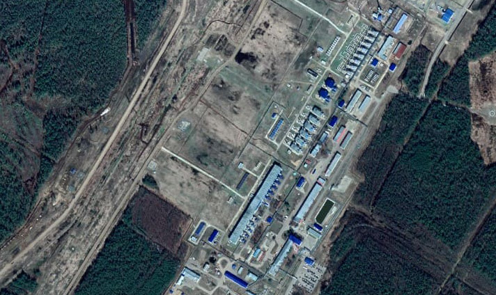
Figure. Satellite image from the WorldView-3 satellite with a spatial resolution of 0.4 m before orthotransformation (left), and the final orthoimagery (right).

Purpose of Orthoimagery (Orthorectification)

Orthoimagery of an area are used as a spatial base for creating maps, topographic plans, and diagrams. They can also be used as standalone products for cartography, cadastral work, engineering surveys, and more.

Modern Earth observation satellites have a spatial resolution of up to 15 cm per pixel and provide wide coverage, allowing for quick retrieval of information over large areas. Unmanned aerial vehicles (UAVs) can also capture images with spatial resolutions of 2-5 cm per pixel.

In accordance with this, satellite and aerial images enable:

  • Creation of orthoimagery at scales up to 1:5000 (using satellite imagery).
  • Creation of orthoimagery at scales up to 1:500 (using UAVs).
  • Generation of high-precision Digital Elevation Models (DEMs) for orthorectification.
  • Detection of previously unnoticed features.
  • Real-time monitoring of changes in the state of objects on the ground.
  • Significant reduction in project timelines due to wide coverage and rapid data acquisition.

Работник

Goals and Objectives of Orthoimagery (Orthorectification):

  • Creation and updating of digital maps, plans, and diagrams at various scales.
  • Execution of land management and cadastral work.
  • Formation of a unified digital cartographic base for real estate cadastre with the subsequent overlay of cadastral division vector layers.
  • Creation of up-to-date digital orthophotomaps as part of a unified electronic cartographic base (EECB).
  • Generation of engineering-topographic maps for engineering and geodetic surveys.
  • Establishment of the remote sensing base for state geological maps.

Advantages of Using Remote Sensing Data

Using archival and new high-resolution and very-high-resolution satellite images with precise orbital georeferencing allows for the production of orthoimagery with high accuracy and detail without the need for ground surveying to obtain control points. Satellite data can be acquired more quickly as they may already be available in the operator's archive.

The use of aerial imagery and images from UAVs/drones for creating orthoimagery requires conducting a new survey, which takes more time due to the need for special permissions and on-site visits. However, orthoimagery generated from orthotransformed aerial images have high visual informativeness and excellent measurement properties.

Prices for services

Cost of Orthoimagery (Orthorectification):

Scale of Orthoimagery (Orthorectification) Satellite Imagery Aerial imagery UAV/Drone

1:500 and 1:1000

-

-

From 1 km2
from 20,000 ₽

1:2000 and 1:5000

-

From 25 km2

from 200,000 ₽

From 5 km2

from 100,000 ₽

1:10000

From 25 km2
from $300

From 50 km2

from 200,000 ₽

-

1:25000 and 1:100000

From 100 km2 from $300

-

-

Cost of Creating Orthophotomaps from Client-Supplied Data (Processing per 1 km2):

Scale of Orthophotomap Creation

Satellite Imagery

Aerial imagery

UAV/Drone

1:500 and 1:1000

-

-

from 1000 rubles

1:2000 and 1:5000

-

from 100 rubles

from 1000 rubles

1:10000

from 0.5 $


The cost of execution is calculated on an individual basis, taking into account a specific of task.

After receiving the task description, we calculate the cost and send you a commercial offer.

Period of execution

The completion time is from 1 working day.

The timeframe for creating orthoimagery depends on:

  • the area of the area of interest (service area);
  • the type of imagery (satellite imagery, aerial imagery, UAV/drone imagery);
  • the number of images;
  • the spatial resolution of the images;
  • the complexity of the terrain;
  • the seasonality of the project;
  • the amount of advance payment;
  • whether the remote sensing data needs to be procured or if the materials are provided by the client;
  • and other factors.

How to place an order:

  1. STEP #1: Submit an application on the website with the following information:
    • Location of the object of interest (coordinates, district name, region, shapefile, etc.);
    • Requirements for the imagery period (the period for which archival data can be used or the need for a new survey);
    • Determination of the required scale, accuracy, and purpose of using the orthophotomaps.
  2. STEP #2: Agreement on the technical task and cost.
    • Photogrammetric work - the price is negotiated in each specific case;
    • The imagery is paid for separately.
  3. STEP #3: Contract signing and commencement of work:
    • From 1 working day after receiving 100% advance payment for remote sensing materials - payment is made only by bank transfer. The remaining payment is made after the completion of the service.

We collaborate with individuals, legal entities, individual entrepreneurs, government and municipal authorities, foreign clients, etc.

Need for consultation?

Fill the form and we will contact you

By clicking the «Send» button, you give your consent to the processing of your personal data, in accordance with Federal Law No. 152-FZ of July 27, 2006 «On Personal Data», on the conditions and for the purposes specified in the Consent to the processing of personal data.

Stages of service provision

Stage #0 (Before contract signing):

  • Determining the purpose of using orthophotomaps and the required accuracy;
  • Checking the availability of archival remote sensing materials and/or planning a new survey of the area of interest;
  • Verifying the selected archival images for compliance with the customer's requirements;
  • Submitting a request to the operator(s) for a new survey (if necessary).

RESULT: possibility (YES/NO) of providing the service

Stage #1 (Before contract signing):

  • Agreeing with the customer on the use of remote sensing data available in the operator's archives;
  • Agreeing with the customer, if necessary, on the satellite from which a new survey will be conducted, the timeframe, and parameters of the new survey;
  • Agreeing with the customer (if necessary) on the requirements for control points, digital elevation models for orthotransformation;
  • Agreeing on the coordinate system and projection requirements for the final product;
  • Final determination of labor and material costs, agreement on delivery times and costs.

RESULT: signed contract

Stage #2 (Contract execution):

1. Selection of source materials.

Depending on the required accuracy and purpose of the product, different data can be selected. The selection of materials strictly follows the customer's requirements. For example, when creating orthophotomaps at a scale of 1:10,000, a planimetric accuracy of no less than 10 meters is required, and materials with a resolution of at least 0.5 meters are needed to meet this accuracy.

2. Preliminary analysis of source materials.

After receiving remote sensing materials, they need to be checked for quality mutual registration of channels, absence of "dead" pixels and missing strips of imagery. The completeness of the materials for the area of interest is also checked.

3. Technical planning of processing procedures.

A technical project should indicate and justify the recommended processing methods. It should take into account the terrain and buildings, image quality, density and distribution of geodetic control points, and the availability of photogrammetric instruments and software.

For technical planning, a scheme for photogrammetric control point densification and a scheme for creating original maps (plans) are prepared. The choice of photogrammetric processing method is justified.

Depending on the volume and quality of planimetric and altimetric preparation, the technological scheme may include:

  • Photogrammetric densification of survey justification (for sparse field image preparation) and subsequent collection of digital information about the area from individual images or stereo pairs oriented based on photogrammetric densification data.
  • Processing individual images or stereo pairs directly based on field control points (for dense image block adjustment) or based on contour points identified on existing images from previous years or on larger-scale maps (plans).

Technical planning of photogrammetric densification includes the selection and marking of points for the photogrammetric control network, as well as the creation of a network diagram.

4. Preliminary image processing.

Preliminary image processing includes the removal of image defects (missing pixels, strips), radiometric, geometric, and atmospheric correction of the images.

5. Photogrammetric processing of the source data.

Photogrammetric processing includes:

  • Creation of preliminary mosaics;
  • Performing interior orientation of the images;
  • Performing relative orientation of the images;
  • Performing exterior orientation;
  • Creating digital elevation models (if stereo imagery is used);
  • Orthotransformation of the data;
  • Creating seamless mosaics;
  • Color balancing of the mosaic.

6. Exporting the generated materials.

The final product can be exported in different formats depending on the customer's software requirements. Additionally, based on the customer's requirements, the final orthophotomap can be divided according to grids, image weight, kilometer marks, etc.

7. Quality control of the work.

In conclusion, a final analytical report is drawn up, which reflects statistical, analytical and technical information on the work performed, and the progress of work execution

Образец ортофотоплана 1_5000 на объекты нефтегазового сектора


Figure 1: Sample orthophoto plan M 1:10,000 for oil and gas sector facilities

The result of the provision of services

Ready orthophotoplan or orthomosaic of the specified type and in the specified format.

Requirements for Source Data

In accordance with regulatory documents for the creation of orthophotoplans, the following requirements are imposed on the accuracy and detail of the source images, plan-altitude basis, and digital terrain model.

Name of Requirements Requirement Values for Scales
1:500 1:1000 1:2000 1:5000 1:10000 1:25000 1:50000

GCP Accuracy:

- Planar, m

- Vertical, m


0.14

0.10


0.28

0.10


0.56

0.10


1.40

0.21


2.80

0.21


7.00

0.52


14.00

1.04

Digital Terrain Model Accuracy, Vertical, m


0.10


0.10


0.10


0.20


0.20


1.00


2.00

Contours Accuracy:

- Planar, m;

- Vertical, m


0.35

0.18


0.70

0.18


1.40

0.18


3.50

0.35


7.00

0.35


17.50

0.88


35.00

3.76

Allowable Resolution

on the Ground Lm, (spatial resolution of the images), m


0,02


0,05


0,10


0,25


0,50


1,25


2,50


Related services

Satellite monitoring and UAV Monitoring
Find out the price
Remote sensing imagery Interpretation & spectral analysis
Find out the price
Topographic Site Plan
Find out the price
Digital Topographic Maps
Find out the price
Thematic mapping. Thematic map
Find out the price
Remote sensing of the earth (RS)
Find out the price
Космический мониторинг территории
Find out the price
Создание и обновление цифровых топографических карт
Find out the price
Составление тематических и специальных карт, планов
Find out the price
Топографический план. Создание топографических планов участка
Find out the price
Дешифрирование данных дистанционного зондирования Земли (ДЗЗ)
Find out the price
Lavrov Viktor Nikolaevich
The material was checked by an expert
Lavrov Viktor Nikolaevich

Aerophotogeodesist, work experience 58 years, Education - Moscow Institute of Geodesy, Aerial Survey and Cartography (MIIGAiK)

Customers

FAQ

  • Location of the object of interest (coordinates, name of the district, region, shapefile, etc.);
  • Requirements for the imaging period (the period for which archival data can be used or the need for a new survey);
  • Determination of the required scale and accuracy, purposes of using orthophotoplans.
This is a photographic image of terrain in orthogonal projection, specified coordinate system and required scale, obtained by ortho-transformation of images using DEM, reference points or RPS coefficients to eliminate distortions caused by survey conditions, survey equipment, image tilt angles and terrain relief, with subsequent stitching of transformed images and cutting orthophotomaps into nomenclature or arbitrary sheets.
  • Location of the object of interest (coordinates, district name, region, shapefile, etc.);
  • Requirements for the imaging period (the time frame for which archival data can be used or the need for a new survey);
  • Determination of the required scale and accuracy, objectives of using orthophotoplans.
Depending on the required accuracy and the purpose of orthophotomaps use, initial photos, reference points and map materials are selected and acquired; primary processing of images is performed, including image defects removal, radiometric, geometric and atmospheric correction of images.
Depending on the volume and quality of plan-altitude preparation the technological scheme of cameral processes provides photogrammetric densification of survey support using single images or stereo pairs oriented on the points of field preparation or contour points identified on available images of previous years or on maps (plans) of larger scale or using RPS coefficients.
Sequentially performed are internal, mutual and external orientation of images, DEM creation (in case stereo imagery is used), orthotransformation of data, creation of seamless mosaic and alignment of color characteristics of the mosaic.
Depending on the Customer's requirements, the final product is exported to a specified format and orthophotos are sliced into nomenclature or arbitrary sheets.
Terms of orthoimagery execution depend on the area of the territory, requirements to the survey parameters. The minimum execution time is from 1 (one) working day
Orthoimagery refers to aerial or satellite images that have been orthorectified, correcting for distortions caused by terrain and sensor characteristics. Unlike standard aerial imagery, orthoimagery provides accurate and geometrically corrected representations of the Earth's surface.
Orthorectification involves correcting geometric distortions in aerial or satellite images to achieve accurate spatial representation. This process considers factors such as topography, sensor tilt, and Earth curvature. It is crucial for producing high-quality orthoimagery, ensuring that features are accurately positioned on the Earth's surface.
Orthoimagery contributes to precise mapping and geospatial analysis by providing accurately scaled and spatially corrected images. This allows for precise measurements, reliable feature identification, and detailed analysis in applications such as land-use planning, environmental monitoring, and infrastructure development.
The main advantages of orthoimagery include accurate geometric representation, improved spatial accuracy, and the ability to make precise measurements. In comparison to non-rectified imagery, orthoimagery is essential for applications requiring precise spatial information, such as cadastral mapping, urban planning, and environmental studies.
Orthoimagery is commonly utilized in industries such as agriculture, forestry, urban planning, and emergency response. It enhances decision-making processes by providing detailed and accurate spatial information. For example, in agriculture, orthoimagery aids in crop monitoring, while in emergency response, it supports quick and informed decision-making during disaster scenarios.

Orthoimagery, also known as orthophotography, is a form of aerial imagery that has been geometrically corrected ("orthorectified") to remove distortions caused by camera tilt, lens distortion, and topographic relief. This results in a uniform scale where the images have the same accuracy as a map. Orthoimagery is widely used in various applications, including mapping, environmental monitoring, urban planning, and agriculture. Here's a guide on how to use orthoimagery effectively:

1. Understanding Orthoimagery

Before using orthoimagery, it's important to understand its characteristics:

  • Georeferenced: Orthoimages are aligned with geographic coordinates, allowing them to be used in conjunction with other spatial data.
  • High Accuracy: These images can be used for precise measurements and analysis.
  • Uniform Scale: Distortions are corrected, making distances and areas accurate.

2. Obtaining Orthoimagery

You can obtain orthoimagery from various sources:

  • Government Agencies: Many countries have national mapping agencies that provide orthoimagery (e.g., USGS in the United States).
  • Online Portals: Websites like Google Earth, Bing Maps, and OpenStreetMap provide access to orthoimagery.
  • Commercial Providers: Companies like DigitalGlobe and Airbus offer high-resolution orthoimagery for purchase.

3. Software for Viewing and Analyzing Orthoimagery

To use orthoimagery, you'll need Geographic Information System (GIS) software:

  • QGIS: A free and open-source GIS application.
  • ArcGIS: A popular commercial GIS software by Esri.
  • Google Earth Pro: Provides tools for viewing and analyzing geospatial data.

4. Importing Orthoimagery into GIS Software

Here's a general process for importing orthoimagery into QGIS:

  1. Download the Image: Obtain the orthoimage file (usually in formats like TIFF, JPEG, or GeoTIFF).
  2. Open QGIS: Launch QGIS on your computer.
  3. Add Raster Layer: Go to Layer > Add Layer > Add Raster Layer.
  4. Select the File: Browse to the location of your orthoimage file and select it.
  5. View the Image: The orthoimage should now be displayed in the QGIS workspace.

5. Using Orthoimagery in GIS

Once the orthoimage is loaded, you can perform various tasks:

  • Overlay with Vector Data: Combine orthoimagery with vector data layers (e.g., roads, boundaries).
  • Measure Distances and Areas: Use tools in GIS software to measure features directly on the orthoimage.
  • Analyze Land Use: Identify different land use types and changes over time.
  • Digitize Features: Manually trace features like buildings, roads, or vegetation directly from the orthoimage to create new vector layers.

6. Applications of Orthoimagery

Here are some common applications of orthoimagery:

  • Urban Planning: Assessing land use, planning new developments, and monitoring construction.
  • Agriculture: Monitoring crop health, planning irrigation systems, and managing fields.
  • Environmental Monitoring: Tracking changes in natural landscapes, deforestation, and wetlands.
  • Disaster Management: Assessing damage after natural disasters like floods, hurricanes, and earthquakes.
  • Infrastructure Management: Monitoring roads, bridges, and utilities for maintenance and planning.

7. Tips for Effective Use

  • Update Regularly: Use the most recent orthoimagery available to ensure accurate analysis.
  • Combine Data Sources: Integrate orthoimagery with other data layers (e.g., demographic data) for comprehensive analysis.
  • Use Appropriate Resolution: Ensure the resolution of the orthoimage is suitable for your specific needs (higher resolution for detailed analysis).

By following these steps and tips, you can effectively utilize orthoimagery in various projects and applications.

Aerial imagery and orthoimagery are both types of photographs taken from an elevated position, typically from aircraft or satellites, but they have significant differences in terms of their characteristics and applications.Here's a detailed comparison:

Aerial Imagery

  • Definition: Aerial imagery refers to photographs taken from the air using aircraft or drones. These images capture the Earth's surface from above and can cover large areas in a single frame.
  • Characteristics:
    • Distortion: Aerial images are subject to distortions caused by camera tilt, lens curvature, and variations in terrain. These distortions mean that scale is not uniform across the image.
    • Perspective View: Aerial images provide a perspective view, where objects further away from the camera appear smaller, and objects closer appear larger.
    • Raw Data: Typically, aerial images are raw and unprocessed, meaning they have not undergone any corrections for distortions or georeferencing.
    • Applications: Used for initial surveys, photography, and visual inspections where precise measurements are not critical.

Orthoimagery

  • Definition: Orthoimagery refers to aerial or satellite images that have been geometrically corrected, or orthorectified, to remove distortions. This process makes the images suitable for accurate mapping and spatial analysis.
  • Characteristics:
    • Geometric Correction: Orthoimages have been processed to correct distortions from camera tilt, lens curvature, and topographic relief. This correction ensures a uniform scale across the entire image.
    • True Top-Down View: Unlike standard aerial imagery, orthoimages provide a true top-down view, as if looking straight down at the Earth's surface. This eliminates the perspective effect.
    • Georeferenced: Orthoimages are aligned with geographic coordinates, making them accurate for use in GIS and allowing for precise measurements and analysis.
    • Applications: Used for mapping, urban planning, environmental monitoring, infrastructure management, disaster response, and any application requiring accurate spatial information.

Key Differences

  1. Distortion and Scale:

    • Aerial Imagery: Contains distortions due to the camera angle and terrain. The scale is not consistent across the image.
    • Orthoimagery: Distortions are corrected, and the scale is uniform, making it suitable for precise measurements.
  2. View and Perspective:

    • Aerial Imagery: Provides a perspective view with objects appearing smaller as they are further from the camera.
    • Orthoimagery: Provides a true top-down, orthographic view, removing the perspective effect.
  3. Georeferencing:

    • Aerial Imagery: Typically not georeferenced in its raw form.
    • Orthoimagery: Georeferenced to a specific coordinate system, allowing integration with other spatial data in GIS.
  4. Applications:

    • Aerial Imagery: Used for general surveys, photography, and qualitative visual inspections.
    • Orthoimagery: Used for detailed mapping, urban planning, environmental studies, and any application where spatial accuracy is critical.

Summary

  • Aerial imagery provides a general view from above, useful for visual assessments but not for precise measurements.
  • Orthoimagery is processed to remove distortions, providing a georeferenced, true top-down view suitable for accurate mapping and spatial analysis.

Digital orthoimagery refers to aerial or satellite images that have been geometrically corrected to have a uniform scale. This correction process removes distortions caused by terrain relief, sensor tilt, and other factors, making the images accurate representations of the Earth's surface. Digital orthoimagery is commonly used in various applications, including:

  1. Mapping and Cartography: Creating accurate and detailed maps.
  2. Urban Planning: Assisting in the planning and development of urban areas.
  3. Environmental Monitoring: Tracking changes in landscapes and ecosystems.
  4. Agriculture: Managing crops and analyzing fields.
  5. Infrastructure Development: Planning and managing roads, bridges, and utilities.
  6. Disaster Management: Assessing and responding to natural disasters.
  7. Real Estate: Evaluating properties and land use.

The process of creating digital orthoimagery involves capturing images using high-resolution cameras mounted on aircraft or satellites, followed by orthorectification, where the images are adjusted to remove distortions and align with a specific coordinate system. The result is a detailed, accurate image that can be used for precise measurements and analysis.

In the context of Geographic Information Systems (GIS), orthoimagery plays a crucial role by providing a base layer of highly accurate, spatially referenced images. Here are key points about GIS orthoimagery:

  1. Accuracy and Scale: Orthoimagery in GIS is corrected for topographic relief, lens distortion, and camera tilt, ensuring that distances and features on the image are as accurate as on the ground.

  2. Integration with Other Data: Orthoimagery serves as a foundational layer in GIS, over which other spatial data layers (such as vector data like roads, boundaries, and points of interest) can be overlaid. This integration enhances spatial analysis and decision-making.

  3. Applications:

    • Urban Planning and Management: Helps in analyzing land use, zoning, infrastructure planning, and urban development.
    • Environmental Monitoring: Used to study changes in natural landscapes, monitor deforestation, track water bodies, and assess environmental impacts.
    • Agriculture: Assists in crop monitoring, land assessment, and precision farming.
    • Disaster Response and Management: Crucial for assessing damage, planning response efforts, and managing recovery after natural disasters.
    • Transportation: Aids in planning and maintaining transportation networks, including roads, railways, and airports.
    • Real Estate and Property Management: Used for property evaluation, land development, and management of real estate portfolios.
  4. Data Sources:

    • Aerial Photography: High-resolution images captured by cameras mounted on aircraft.
    • Satellite Imagery: Images captured by earth observation satellites, offering various resolutions and spectral bands.
  5. Orthorectification Process:

    • Ground Control Points (GCPs): Identifiable points on the ground with known coordinates are used to correct the image.
    • Digital Elevation Model (DEM): A model of the terrain’s surface used to correct distortions caused by elevation changes.
  6. GIS Software:

    • Popular GIS software like ArcGIS, QGIS, and ERDAS IMAGINE provide tools for integrating and analyzing orthoimagery.
    • These tools allow for the manipulation, analysis, and visualization of orthoimagery in conjunction with other spatial datasets.
  7. Data Formats:

    • Orthoimagery is often stored in formats such as GeoTIFF, which include georeferencing information to align the images with real-world coordinates.
    • Other formats include JPEG2000, MrSID, and ECW, which offer various levels of compression and quality.

Using orthoimagery in GIS enhances spatial analysis capabilities, providing a realistic and accurate representation of the Earth's surface that supports informed decision-making across multiple fields.

High-resolution orthoimagery refers to orthoimages with a very fine level of detail, often with pixel resolutions of one meter or less. This high level of detail makes high-resolution orthoimagery invaluable for a variety of applications that require precise and detailed visual information. Here are some key aspects and applications of high-resolution orthoimagery:

Key Aspects

  1. Resolution: High-resolution orthoimagery typically has a ground sample distance (GSD) of less than one meter, meaning each pixel represents less than one meter on the ground. Common high-resolution standards include 30 cm, 50 cm, or even finer resolutions.

  2. Accuracy: These images undergo rigorous orthorectification processes to ensure geometric accuracy, making them suitable for detailed analysis and precise measurements.

  3. Data Sources:

    • Aerial Photography: Captured by aircraft flying at relatively low altitudes, providing high-resolution images of specific areas.
    • Satellite Imagery: High-resolution satellite sensors, such as those on the WorldView, GeoEye, and Pleiades satellites, can capture detailed images of large areas.
  4. File Formats: High-resolution orthoimagery is often stored in formats like GeoTIFF, JPEG2000, and MrSID, which support large file sizes and georeferencing.

Applications

  1. Urban Planning and Development:

    • Detailed mapping of infrastructure, buildings, and land use.
    • Planning new developments, zoning, and land allocation.
  2. Environmental Monitoring:

    • Tracking changes in vegetation, wetlands, and other natural features.
    • Assessing environmental impacts of human activities and natural events.
  3. Agriculture:

    • Precision farming by analyzing crop health, soil conditions, and irrigation needs.
    • Monitoring crop growth and planning harvests.
  4. Disaster Management:

    • Rapid assessment of damage after natural disasters like floods, hurricanes, and earthquakes.
    • Planning and coordination of emergency response and recovery efforts.
  5. Transportation and Infrastructure:

    • Planning and maintaining roads, railways, airports, and other transportation networks.
    • Monitoring construction progress and infrastructure health.
  6. Real Estate and Property Management:

    • Detailed property evaluations and land use analysis.
    • Managing and developing real estate projects.
  7. Utilities and Energy:

    • Managing utility networks (e.g., power lines, pipelines) and planning new installations.
    • Monitoring environmental impacts of energy production and distribution.

Benefits

  1. Precision: High-resolution images allow for accurate mapping and analysis, crucial for tasks requiring detailed information.
  2. Up-to-Date Information: Frequent updates to high-resolution imagery provide current data for dynamic analysis and decision-making.
  3. Enhanced Analysis: The fine detail in high-resolution images supports advanced analytical techniques, including machine learning and computer vision applications.

Challenges

  1. Large Data Volumes: High-resolution images produce large datasets, requiring significant storage and processing power.
  2. Cost: Acquiring high-resolution orthoimagery, especially from commercial satellite providers, can be expensive.
  3. Data Management: Managing and integrating high-resolution imagery with other GIS data can be complex and requires specialized software and expertise.

Conclusion

High-resolution orthoimagery is a powerful tool in GIS, offering detailed and accurate visual information that supports a wide range of applications. Its precision and level of detail make it indispensable for tasks that demand high accuracy and up-to-date information.

Licenses

Warranty

We guarantee 100% quality of services in accordance with GOST R 58854-2020. Cooperating with GEO Innoter specialists, you exclude risks and losses! The availability of experienced qualified personnel, specialized software allows us to ensure timely and high-quality performance of works!

Our partners