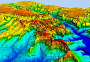
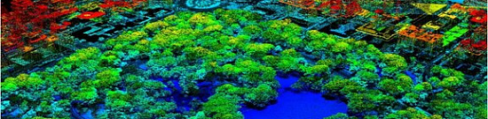
Vector data are geometric objects described by points, lines and polygons that can be easily edited and analysed using specialised geographic information systems (GIS). They offer advantages over raster data, such as the ability to change scale without loss of quality, a more accurate representation of geometric objects and a better ability to perform analysis and modelling.
Tablet vectorisation is performed using special software that allows the user to trace the contours and boundaries of objects in a raster image and automatically convert them into vector elements. This process may include such operations as point, line and polygon detection, as well as attribute data filling.
Vectorization of planchets is an essential service in cartography, allowing for the efficient use and analysis of geospatial data contained in raster planchets.
Vectorization of paper planchets for cartography is needed to convert information from paper maps into a vector data format. This enables the creation of more accurate and flexible maps that can be utilized in various GIS applications and software. Vectorization also improves the accessibility of maps, as vector data can be scaled without loss of quality and easily analyzed, edited, and styled. Additionally, vectorization allows for the creation of stylized maps with different layers and attributes, making them more visually appealing and informative.


Goals and Objectives of Vectorization
The goal of vectorization of paper topographic maps is to transform information presented on paper topographic maps into vector data format. This enables the creation of more accurate and flexible cartographic products that can be utilized in various applications.
Vectorization of paper planchets allows:
- Improve the accuracy of cartographic data: Vectorization allows for more precise determination of the boundaries of objects on the map, such as roads, rivers, buildings, and other landscape elements. This is crucial for creating more accurate and reliable maps.

- Facilitate editing and data updates: Vector data can be easily modified or updated as needed. This enables cartographers to make changes to maps and update information on new objects or changes to existing ones.
- Enhance the visual representation of the map: Vectorization allows for the creation of more aesthetically appealing and understandable maps. Vector data can be easily stylized and displayed using various colors, patterns, and symbols for improved visual representation of information.
- Provide analysis and modeling capabilities: Vector data can be used for analyzing and modeling various geographical phenomena. For example, they can be used to determine optimal routes, calculate areas or volumes of objects, and create three-dimensional models of the landscape.
- Improve data accessibility and distribution: Vector data can be easily transferred and distributed through various electronic means such as the Internet, GIS systems, or mobile applications. This facilitates access to cartographic data and its use in various applications and systems.
The tasks of vectorization of paper planchets for cartography may include the following:
- Define and highlight object boundaries: This involves defining the boundaries of objects such as roads, rivers, buildings, forested areas, and other landscape elements on a paper map. The task is to accurately determine object boundaries and highlight them in vector imagery.
- Create points and lines: Vectorization also involves creating points and lines to represent various objects on the map. For example, points can be used to mark the locations of cities or other significant objects, and lines can be used to indicate roads, rivers, or territorial boundaries.
- Attribute data filling: In addition to the geometric representation of objects, vectorization also includes filling attribute data for each object. For example, attributes may include information about the name of the object, its type, height, area, and other characteristics.
- Resolve conflicts and errors: During vectorization, conflicts and errors may arise, such as overlapping objects or incorrect boundary determination. The task is to resolve these conflicts and correct errors to obtain an accurate and reliable vector representation of the map.
- Quality control: After completing vectorization, it is necessary to conduct quality control of the data. This includes checking the accuracy of object boundaries, the correctness of attribute filling, and the overall correspondence of the vector representation to the paper map.
- Create layers and stylization: After vectorization, various layers can be created for different types of objects, such as roads, rivers, buildings, etc. Then, stylization can be applied to the layers to create more aesthetically appealing and understandable maps.
- Export and distribute data: After completing vectorization, data can be exported to various formats, such as Shapefile or GeoJSON, and distributed through various means, such as the Internet or GIS systems.
All these tasks help transform information from paper planchets into a vector data format that can be used to create more accurate, flexible, and accessible cartographic products.
Prices for services
|
Events |
Free / Cost per unit |
|
Consultation |
Free |
|
Collection of images (if necessary), preliminary analysis of source data, additional and reference materials |
Free |
|
Ordering images (if necessary) |
From $0.5 to $70 per 1 km2 depending on the type of imaging (archive-new, mono-stereo, resolution) * |
|
Cost of creating a COFP (Cartographic Orthophotomap) |
From $1 per 1 km2, calculated individually for each specific order and depends on the amount of processed remote sensing data, availability (or absence) of control points, and the used mapping coordinate system (MCS) |
|
Cost of creating a vector plan (information refinement) 1 sheet of digital vector plan |
Cost of creating 1 vector plan from 40,000 rubles and depends on the map scale, complexity category, and execution time. The cost of refining information based on COFP depends on the degree of obsolescence of the raster plan, but not more than +50% of the creation cost. |
|
Execution period |
From 20 working days (depends on the volume, complexity category, availability of remote sensing data, additional and reference materials) |
Full cost of creating a vector plan (from 40,000 rubles) consists of the cost of remote sensing data used for refining orthophotomap information, the cost of creating it, the complexity category, and creation time. The cost of refining information based on COFP depends on the degree of obsolescence of the raster plan, but not more than +50% of the creation cost.
The cost of execution is calculated on an individual basis, taking into account a specific of task.
After receiving the task description, we calculate the cost and send you a commercial offer.
Period of execution
|
Coordination of questions, analysis of the availability of remote sensing data, additional and reference data |
From 1 to 5 days* |
|
Contract signing |
From 1 to 5 days* |
|
Receiving images |
From 3 to 10 days** |
|
Receiving source material (paper plan or scanned) for tablet vectorization from the Customer |
From 1 to 20 days* |
|
Creation of COFP (Cartographic Orthophotomap) for information refinement |
5 days* |
|
Tablet vectorization |
15 days* |
|
Execution of vectorization checks |
From 5 to 10 days* |
|
Preparation of a technical report on the work performed |
From 5 to 10 days |
|
TOTAL DURATION |
20 days* |
* working days
** from the date of receiving 100% advance payment for remote sensing data materials. The completion dates depend on the number of tablets for vectorization, the scale and type of the created product, the availability of archival remote sensing data materials, additional and reference materials.
How to place an order:
Need for consultation?
Fill the form and we will contact you
Stages of service provision
The result of the provision of services
Vectorised tablets in formats, projection, coordinate system and heights stipulated in the Terms of Reference, RS materials in the form of digital orthophotos and original images, a set of additional and reference materials used in the work, editorial and technical instructions, technical report on the work performed. All results are transferred on electronic media or via Internet via FTP server, and text materials are also duplicated in printed form.Related services

Customers


FAQ
- area of interest (location / coordinates of the object in any convenient form, and area of the object);
- the specific problem to be solved using a digital topographic map
- Terms of vectorisation of plan sheets on the basis of space or aerial survey data depend on the volume and complexity of the order. Minimum term - from 5 (five) working days;
- Terms of delivery of ready vectorised plans from 5 (five) working days.
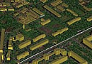
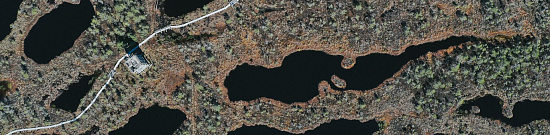
Conversion of raster images into vector graphics in cartography is an important process that allows obtaining more flexible and scalable data for creating maps and Geographic Information Systems (GIS). This process involves several stages:
-
Scanning or importing raster image: At the beginning of the process, a raster image, such as a photograph or scanned map, is imported into a computer environment.
-
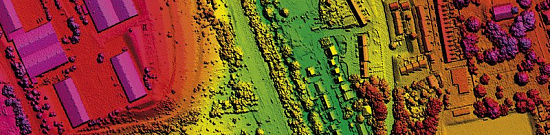
Georeferencing: This step involves linking the raster image to geographic coordinates to determine its location on the map. Control points, such as geodetic markers or known geographical features, are used for this purpose. Georeferencing allows determining where various elements of the raster image are located on the map.
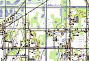
-
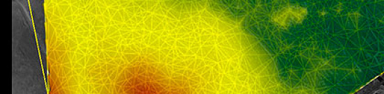
Vectorization: At this stage, the raster image is transformed into vector graphics. This is done by outlining the contours and boundaries of objects in the image, such as roads, rivers, buildings, and other geographical elements. These contours and boundaries are then converted into vector geometric shapes, such as lines, polygons, and points.
-
Attribution: Attributes or characteristics, such as name, object class, height, area, and other information useful for cartography and data analysis, are assigned to each vector object.
-
Editing and correction: After vectorization and attribution, data editing and correction are performed. This includes error correction, object boundary alignment, and overall data quality improvement.
-
Map creation: In the final stage, a map is created using the vector data obtained from the conversion of the raster image. This may involve creating various data layers, a legend, scale, symbology, and other map elements.
The process of converting raster images into vector graphics makes it easier to work with data and provides the ability to scale the map without losing quality. Vector data can also be used for spatial information analysis, as in GIS for decision-making.
Licenses


Our partners


")


")

Sat-Sun: Non-working days