Sat-Sun: Non-working days
Annotation
A topographic map is the primary source of information about the terrain. The use of such information can open the door to a myriad of possibilities in completely different fields. From construction to archaeology, from planning personal recreation to monitoring the environmental situation on the ground. In addition, the article provides a brief history of maps, their creation, and a sprinkle of interesting facts about modern topographic maps.
The article may be useful for people interested in geography, travel, as well as for tourists, travelers, and explorers who use topographic maps to plan their routes and navigate in the terrain.
Concept of a Map
Map (geographical) — is an image of the Earth's surface constructed on a plane according to certain mathematical rules.
The earliest maps, surprisingly, were related to the sky rather than the earth. The first maps were created or written on stone. Tribes used these maps to mark their territory. The cave drawings represented bulls and humans, likely depicting ancient people hunting animals. However, in addition to everything else, they added points, arranged not entirely chaotically, to the drawings. These points (rock drawings) found on the walls of the Lascaux cave, dating back to approximately 16500 BC, depict part of the night sky, constellations, including bright stars.
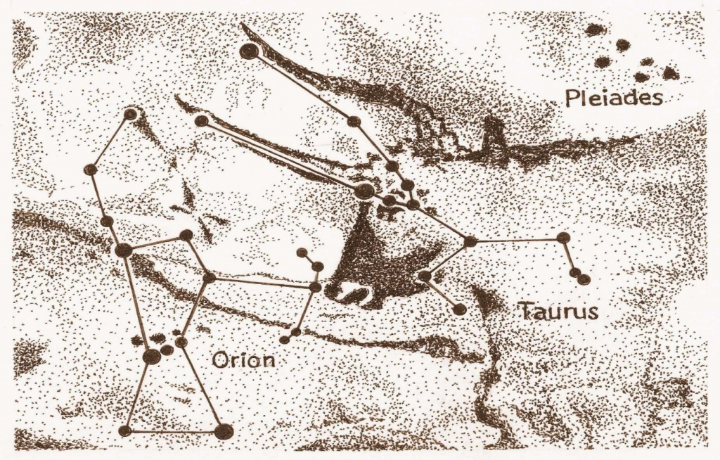
Figure 1 Sky Map in the Lascaux Cave (lines connecting points are artificially made)
However, a more standard and familiar map of the terrain was created not so long ago. Another ancient image resembling a map was created at the end of the 7th millennium BC in Çatalhöyük (Anatolia, modern Turkey). This rock drawing may represent a plan of the Neolithic village that was here, but recent research questions the definition of this painting as a map.
The next revolution in cartography was the creation of the first atlases of the Earth by Gerhard Mercator (the same Mercator whose map projections are used by Western countries in mapmaking) and Abraham Ortelius. Mercator had to establish cartography as a science: he developed the theory of map projections and a system of designations. Ortelius's atlas, titled "Theatrum Orbis Terrarum," was printed in 1570, while Mercator's complete atlas was printed only after his death. These maps were highly accurate, thanks to latitudes and longitudes, which became determined by more precise and sophisticated methods.
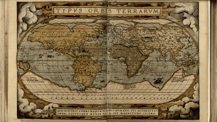
Figure 2 World Map 1570. Ortelius Abraham, Diesth Aegid, Llwyd, Humphrey
Concept of a Map
Map (geographical) — is an image of the Earth's surface constructed on a plane according to certain mathematical rules.
The earliest maps, surprisingly, were related to the sky rather than the earth. The first maps were created or written on stone. Tribes used these maps to mark their territory. The cave drawings represented bulls and humans, likely depicting ancient people hunting animals. However, in addition to everything else, they added points, arranged not entirely chaotically, to the drawings. These points (rock drawings) found on the walls of the Lascaux cave, dating back to approximately 16500 BC, depict part of the night sky, constellations, including bright stars.

Figure 1 Sky Map in the Lascaux Cave (lines connecting points are artificially made)
However, a more standard and familiar map of the terrain was created not so long ago. Another ancient image resembling a map was created at the end of the 7th millennium BC in Çatalhöyük (Anatolia, modern Turkey). This rock drawing may represent a plan of the Neolithic village that was here, but recent research questions the definition of this painting as a map.
The next revolution in cartography was the creation of the first atlases of the Earth by Gerhard Mercator (the same Mercator whose map projections are used by Western countries in mapmaking) and Abraham Ortelius. Mercator had to establish cartography as a science: he developed the theory of map projections and a system of designations. Ortelius's atlas, titled "Theatrum Orbis Terrarum," was printed in 1570, while Mercator's complete atlas was printed only after his death. These maps were highly accurate, thanks to latitudes and longitudes, which became determined by more precise and sophisticated methods.

Figure 2 World Map 1570. Ortelius Abraham, Diesth Aegid, Llwyd, Humphrey
Properties of Topographic Maps
The immense practical significance of maps and the variety of their applications are determined by the properties of cartographic representation. The most important of these properties include:
- Scale, i.e., the strict proportionality of the cartographic representation, allowing for the maximum accuracy permitted by the map scale, to determine the geographical and mutual position of the objects shown on it - their coordinates, territorial dimensions, and arrangement;
- Clarity and Expressiveness of cartographic representation, allowing for the quick and unambiguous perception of the meaning of each element. This is achieved by applying a clear, scientifically developed system of graphical, color, and alphanumeric designation of depicted objects on the maps;
- Purposeful Content and Informational Capacity of the representation, based on the rational selection, generalization, and systematic display of the most essential features and objects of the mapped territory. This allows for a quick, comprehensive perception of not only the external features of depicted objects but also their more diverse characteristics, including those not perceived visually directly on the ground but are of significant importance (e.g., depths of water bodies, marshland permeability, elevation marks, magnetic declination, etc.). At the same time, the map enables the simultaneous consideration of the depiction of a significant-sized area, quickly and comprehensively perceiving the general nature and structural features of the terrain.
Maps that have sufficient content to solve various engineering and technical tasks are called topographic maps. Topographic maps depict terrain, vegetation, rivers, lakes, open spaces, populated areas, routes and means of communication, state and administrative borders, etc. The completeness, detail, and accuracy of terrain depiction on the map depend mainly on its scale.
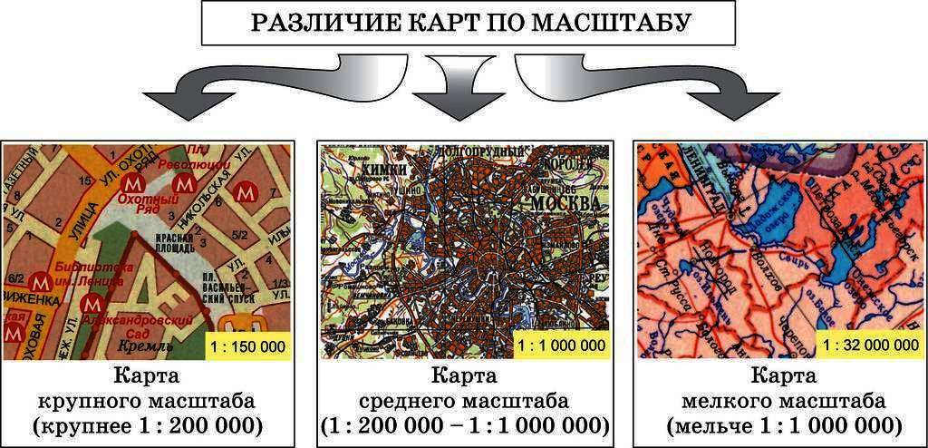
Topographic maps are created at scales of 1:1,000,000, 1:500,000, 1:200,000, 1:100,000, 1:50,000, 1:25,000, and 1:10,000. Maps with scales of 1:5,000 and larger (1:2,000, 1:1,000, 1:500) are considered large-scale and are usually called plans.
Dividing maps into sheets according to some system is called grid referencing. The system of sheet designations is called nomenclature.
In comparing maps of different scales, the one with a smaller scale is considered larger. For example, a map with a scale of 1:100,000 is larger than a map with a scale of 1:200,000. The larger the scale of the map, the more detailed the terrain is depicted on it.
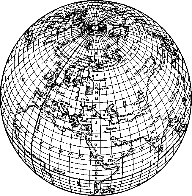
Figure 3. International Grid Referencing
The nomenclature and grid referencing of topographic maps of larger scales are constructed as follows. Each sheet of a 1:1,000,000-scale map is divided into 4 sheets of a 1:500,000-scale map (designated by capital Russian letters: A, B, V, G), or into 36 sheets of a 1:200,000-scale map (designated by Roman numerals: I, II ... XXXVI), or into 144 sheets of a 1:100,000-scale map (designated by Arabic numerals from 1 to 144).
A 1:100,000-scale map (20" latitude and 30" longitude) is divided by meridians and parallels into 4 sheets of a 1:50,000 scale, which are designated by capital Russian letters: A, B, V, G. A 1:50,000-scale map is divided into 4 sheets of a 1:25,000 scale (designated by lowercase Russian letters: a, b, v, g). A 1:25,000-scale map is divided into 4 sheets of a 1:10,000 scale (designated by Arabic numerals: 1, 2, 3, 4). An example of the nomenclature of a 1:10,000-scale map: [N-37-4-B-a-3].
Differences Between Topographic Map and Plan
The main difference lies in their purpose. A plan is originally a large-scale drawing with conventional symbols. Its purpose is to depict a specific area. Plans are created at scales of 1:500, 1:1000, 1:2000, and 1:5000. A topographic map, on the other hand, illustrates the terrain, showing the location of water bodies, vegetation, and soils. They are created at large scales (1:10,000, 1:25,000, 1:50,000) and medium scales (1:100,000, 1:200,000), as defined by regulatory documents. The appropriate scale is chosen based on the requirements for the level of detail. The larger the scale, the more accurate the depiction of information about vegetation, greenery, roads, and terrain objects.
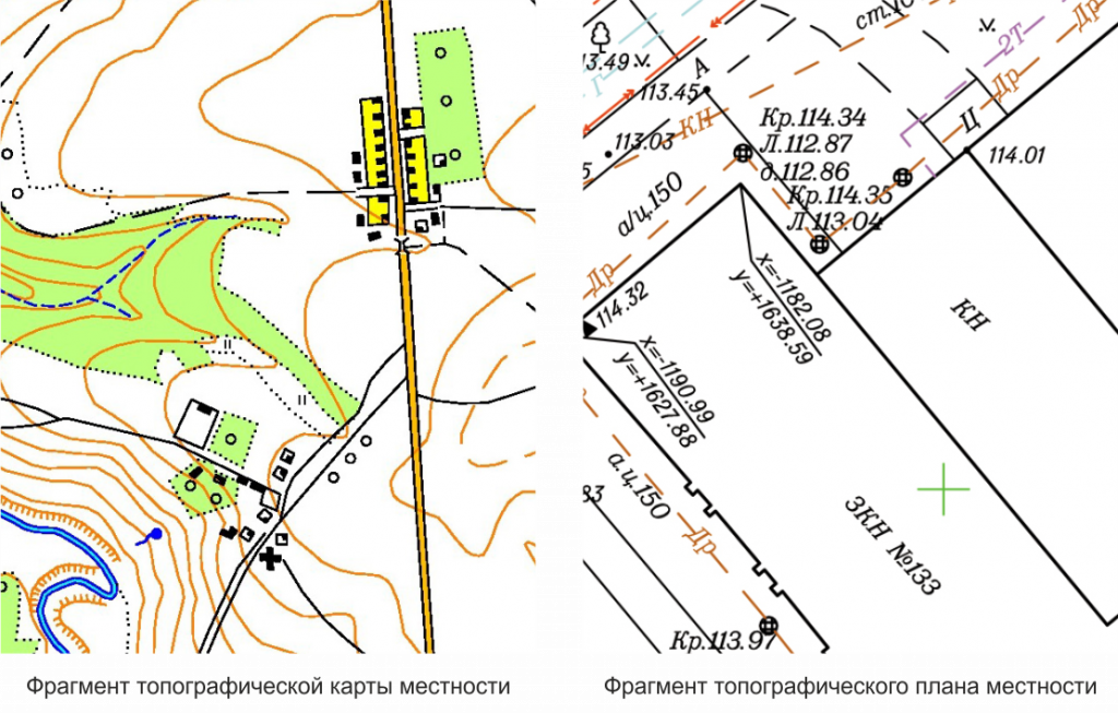
Table 1. Comparison of a Plan and a Topographic Map
|
Land Plan |
Topographic Map |
|
|
Scale and Frames |
Any convenient frames, often sized 40x40 cm or 50x50 cm. Scale larger than 1:5000 (inclusive). |
In accordance with the nomenclature of topographic maps. Scale smaller than 1:10,000 (inclusive). |
|
Coordinates |
Not tied to geographical coordinates; only the direction to the north is indicated - by an arrow or at the top of the map. Tied to plan coordinates, with a kilometer grid. |
It has a degree and kilometer grid; precise geographical coordinates can be obtained for any object. |
|
Classification |
Due to the lack of ties to geographical coordinates, it is not classified. However, schematics of engineering communications, land plots, etc., are available for official use. |
Topographic maps were classified until recently. The largest scale of 1:50,000 is declassified in parts. |
|
Level of Detail |
Indicates quite a few local landmarks, down to individual trees. |
They try to rely on landmarks that do not disappear over the years - for example, buildings. |
|
Survey Method |
Instrumental. |
Aerial photography. |
Foundation of Map Creation
Geodetic constructions on the map are based on aerial photography. It allows obtaining information about a large area in a short period. However, not only aerial photography is used in the process, but also data from high-resolution satellite imagery and remote sensing of the Earth. This speeds up the process of creating a topographic map. Considering that the image is applied to the map horizontally, horizontal shooting is carried out to convey all the features of the terrain with its strong and weak sides. A system of conventional symbols is used to denote objects. Note that before starting the survey work, attention should be paid to the construction of the reference geodetic network. It is an important component in the process of creating topographic maps.
Why Map Creation is Always Relevant
Once created, a topographic map of an area cannot remain relevant after 5 or 10 years. Furthermore, it becomes outdated practically at the moment of its development. This is due to the rapid pace of changes on the ground. As new objects emerge (buildings, structures, engineering communications, vegetation, water bodies), it is necessary to update and keep the maps current. Map updates should be performed when changes reach 20–40% within a significant contour load depending on the total number of contours and objects. The main reasons for updates include:
-
changes to the road network (main roads, railways, highways);
-
scale changes in cities and other settlements;
-
construction of large enterprises beyond the boundaries of settlements;
-
changes in the hydrographic regime of the area;
-
greenery that hinders orientation on the ground.

Figure 4. a) Fragment of the original topographic map sheet
b) "Resource-DK" data
c) Fragment of the updated topographic map sheet
How the Map Development Process is Organized
The creation of topographic maps is a process with a clear algorithm of actions. Geodesists use Earth Remote Sensing (ERS) data as the basis. Access to information from various space vehicles significantly simplifies the work. ERS data must be processed and deciphered for subsequent use. To achieve this:
-
perform photogrammetric processing of ERS data obtained;
-
create a digital terrain model (DTM);
-
carry out the vectorization of the elements of the topographic map content;
-
determine the features of the terrain, the height, and shape of anthropogenic and natural objects;
-
conduct field surveys to verify deciphered information;
-
create an orthophotoplan.
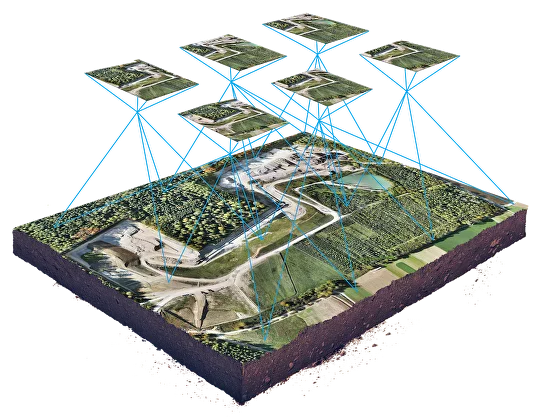
Figure 5. Orthophotoplan for creating a topographic map of the area
Military Purpose of Topographic Maps
Topographic maps, as measuring documents and the main sources of information about the terrain, serve as one of the most important means of managing troops. They are used to study the terrain, orient in combat conditions, perform necessary measurements and calculations in the study and assessment of the situation, decision-making, organizing combat actions, and assigning combat tasks to subordinate troops. Maps are essential for organizing the interaction of troops when performing combat tasks. They determine the coordinates of targets and perform topogeodetic tying of elements of the combat order of all branches of the armed forces, as well as carry out various design and military-engineering calculations.
According to their scales, main purpose, and use in various command and staff levels, Russian topographic maps can be conventionally divided as follows (Table 2).
Table 2. Classification of topographic maps by scale
|
Map Scales |
Map Classification |
|
|
By Scales |
By Main Purpose |
|
|
1 : 25,000 1 : 50,000 |
Large-scale |
Tactical |
|
1 : 100,000 1 : 200,000 |
Medium-scale |
Operational |
|
1 : 500,000 1 : 1,000,000 |
Small-scale |
Maps with scales of 1:25,000–1:100,000 are intended for the work of commanders and staffs in organizing, conducting combat, and managing troops in battle and are called tactical maps. They are most widely used as working maps in the tactical level of troop management. These maps are used to study and assess the terrain in preparation for and during combat, determine the coordinates of firing positions of missile and artillery troops, technical means of reconnaissance, as well as coordinates of targets, and perform measurements and calculations in the design and construction of military-engineering structures and other objects.
The main tactical map is considered to be the map at a scale of 1:100,000.
The map at a scale of 1:200,000 is especially convenient as a road map, as it vividly and sufficiently fully depicts the road network for orienting on the terrain. It characterizes its suitability for the movement of vehicles and combat vehicles. This map allows studying and assessing the road network and the general nature of the terrain, water boundaries, forested areas, and major population centers. This is facilitated by references to the terrain placed on the reverse side of the map sheets. The references contain in a generalized and systematized form necessary additional information about the nature of the terrain and individual most important objects that cannot be displayed on the map itself.
Maps with scales of 1:200,000 and 1:500,000 are intended for studying and assessing the terrain in planning and preparing operations, for managing troops during operations and planning troop movements. The map at a scale of 1:500,000 is also used by front-line aviation as a flight map.
Table 3. Correspondence of map scales to terrain objects
|
Terrain Objects |
Represented on Maps at a Scale of |
|||
|
1 : 50,000 |
1 : 100,000 |
1 : 200,000 |
1 : 500,000 |
|
|
Highways |
All |
All |
All |
Partially |
|
Dirt roads |
All |
Main |
Main |
Rarely |
|
Populated places |
All |
All |
With more than 10 houses |
Not more than one per 25 km 2 |
|
Separate yards |
All |
Partially |
Rarely |
None |
|
Rivers longer than |
0.5 km |
1 km |
2 km |
5 km |
|
Lakes larger than |
0.5 hectares |
2 hectares |
8 hectares |
50 hectares |
|
Swamps larger than |
5 hectares |
25 hectares |
100 hectares |
600 hectares |
|
Forests larger than |
2.5 hectares |
10 hectares |
40 hectares |
100 hectares |
Where can a 1:10,000 scale topographic map be applied:
-
Urban Planning: 1:10,000 scale topographic maps are widely used in urban planning for the planning and development of urban areas. They allow detailed investigations of the terrain, identification of locations for building construction, roads, parks, and other infrastructure.
-
Engineering Surveys: In engineering surveys, such as road, bridge, or pipeline construction, 1:10,000 scale topographic maps are used to determine the terrain, water bodies, forested areas, and to plan routes and identify optimal locations for construction.
-
Spatial Planning: In spatial planning, such as the development of urbanization plans or regional development plans, 1:10,000 scale topographic maps provide information about current land use, land boundaries, the presence of natural objects, and other factors that may affect planned projects.
-
Urban Planning: 1:10,000 scale topographic maps are used in urban planning to define city boundaries and plan the development of urban infrastructure. They allow detailed views of street networks, development zones, parks, recreation areas, and other city features.
-
Land Management and Planning: 1:10,000 scale topographic maps are used in land management and planning to define land boundaries, plan land use, and assess the potential of land resources. They allow the analysis of current land use structures, identify areas for agricultural activities, industrial use, residential development, and other purposes.
-
Environmental Protection: 1:10,000 scale topographic maps are applied in environmental protection for the study and monitoring of natural and ecologically significant areas. They help identify the boundaries of reserves, parks, water protection zones, and other nature conservation areas, as well as analyze the impact of human activities on the environment.
Where can a 1:25,000 scale map be applied:
-
Geological and Geographical Research: 1:25,000 scale topographic maps are used in geological and geographical research to study natural resources, mountain ranges, rivers, lakes, and other geographical features of regions. They help identify geological structures, determine soil types, vegetation, and conduct geomorphological studies.
-
Resource Management: They assist in the management of natural resources, such as forests, for planning logging activities and nature conservation.
-
Geological Studies: 1:25,000 scale topographic maps are used by geologists and geological researchers to study the geological structure of the terrain. They can help determine the boundaries of rock formations, discover water resources, hydrocarbon deposits, sand quarries, and other geological features.
-
Forestry: In forestry, 1:25,000 scale topographic maps are used to plan logging, define boundaries of forested areas, industrial use of forests, and monitor the condition of forests. They also assist in assessing the accessibility of forest roads and planning logging activities.
-
Construction Planning: 1:25,000 scale topographic maps are applied in construction to determine the topographic features of the terrain and plan the placement of buildings, roads, and other infrastructure. They can help choose the most convenient locations for construction, assess potential obstacles, and risks.
-
Military: A map of scale 1:25,000 is used in the military for detailed studies of individual key points and areas during crossing water barriers, airborne landings, etc. They are also used for more accurate measurements and calculations in the design and construction of military engineering structures.
Where can a 1:50,000 scale map be applied:
-
Local Studies: 1:50,000 scale topographic maps can be used in local studies, such as regional development planning, terrain definition, and the study of natural and cultural resources in the region.
-
Geological Studies: 1:50,000 scale topographic maps are used by geologists and geological researchers for a general study of the geological structure of the terrain. They can help determine types of rock, the presence of ore deposits, geological faults, and other geological features. Additionally, the topographic map may contain information about geological reserves, marshy areas, and other geological parameters.
-
Archaeological Research: Archaeologists can use 1:50,000 scale topographic maps to search for and study archaeological objects and locations. Maps may indicate settlements, historical sites, and other objects related to archaeological interests.
-
Military: A map of scale 1:50,000 is primarily used in defense and, in offensive operations, especially during the breakthrough of the enemy's defense, river crossings, airborne landings, etc. They are also used for more accurate measurements and calculations in the design and construction of military engineering structures.
Where can a 1:100,000 scale map be applied:
-
Engineering Geological Studies: 1:100,000 scale topographic maps are used in engineering and geological studies to explore geological structures, terrain relief, soil cover, and geological resources of the region. They help determine optimal locations for the construction of engineering objects.
-
Land Management: Maps of this scale are used in land management to determine land boundaries, plan agricultural development, assess land resources, and conduct land use.
-
Aerial Photography: When conducting aerial photography, 1:100,000 scale topographic maps are used as source material for creating photogrammetric maps and terrain plans. They provide a general cartographic base for aerial photography work.
-
Research and Scientific Work: 1:100,000 scale topographic maps can be used in research and scientific work. They provide general information about the terrain and help researchers understand the overall structure and features of the region. Maps can be used to study geographical, ecological, or geological parameters.
Where can a 1:200,000 scale map be applied:
-
Orientation in Large Regions: 1:200,000 scale topographic maps provide a general cartographic picture of large regions. They can be useful for pilots, geologists, researchers, and other professionals who need to understand the overall context of the terrain and related natural and geographical features.
-
Research and Expeditions: 1:200,000 scale topographic maps can be used by researchers and scientists during research or expeditions in remote areas. They provide information about the territory, relief, and terrain, which can be useful for planning and navigating during research work.
-
In all command and staff institutions from battalion and above, a map of scale 1:200,000 is used for terrain orientation during marches. In motorized infantry, tank units, and formations during offensive operations, especially when pursuing the enemy, it is used as the main map.
Conclusion
Topographic maps are essential tools for planning journeys, navigation, construction, and research, providing detailed information about the terrain, its relief, elevations, and other characteristics. This makes them an invaluable companion for anyone wanting to explore the world around them.
Topographic maps can be created using various technologies and methods, allowing the production of maps with different scales and levels of detail.
Despite the existence of numerous electronic maps and navigation apps today, topographic maps remain relevant and useful tools for engineers, military personnel, nature enthusiasts, tourists, travelers, and researchers.
