your companion in the world
of geospatial solutions
of geospatial solutions
Operation mode:
Mon-Fri: 10:00 - 18:00
Sat-Sun: Non-working days
Customer
Oil and gas production companyProject's objective
Forecast of oil and gas content of the field of the Customer's license area. Tasks set by the customer to perform:- Mapping of local and regional structures.
- Assessment of oil and gas content and resource potential of the region.
- Development of recommendations for the placement of priority exploration wells.
- Assessment of the obtained material for the ecological state and technogenic pollution of the license area.
Completed work
Work description
- Collection of geological and geophysical information on the area of work and adjacent territories.
- Acquisition of satellite images and necessary cartographic materials.
- Analysis of remote sensing data on the licensed subsoil use area.
- Structural analysis of remote sensing materials with drawing up a scheme of local forecasting and search criteria.
- Assessment of the prospects for the oil and gas potential of the region.
- Specialized interferometric processing of radar data of the most promising and operating objects.
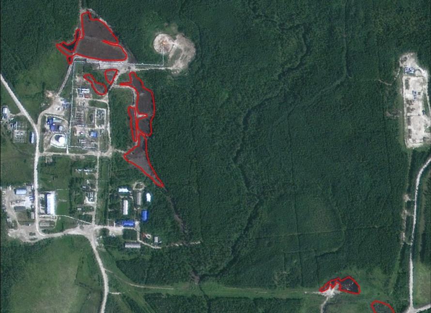
- Assessment of the material obtained for the ecological state and technogenic pollution of the territory, the infrastructure of the region and the state of industrial facilities.
Results
- tectonic zoning map of the area of work (scale 1: 100,000);
- structural map of the site, with the position of the contours of local and regional structures based on remote sensing data (space and geophysical) (scale 1: 100,000);
- assessment of the oil and gas content of the territory, based on the analysis of hydrocarbon micro-seepage, affecting the change in spectral characteristics determined from satellite images (scale 1: 100,000);
- map of local structures and faults (scale 1: 100,000);
- structural maps of promising areas (scale up to 1: 25000);
- map of oil and gas geological zoning of the site with ranking of structures according to the degree of their prospects in accordance with the probability of geological success (scale 1: 100,000);
- a map of the current state of the landscape with a detailed digital elevation model (updated location of water sources, roads, bridges, oil and gas pipelines, outbuildings);
- diagram of the ecological state and analysis of the pollution of the territory;
- explanatory note (report) with an overview of the geological structure of the territory, assessment of hydrocarbon resources of identified promising local objects.
Need for consultation?
Fill the form and we will contact you
Operation mode:
Mon-Fri: 10:00 - 18:00
Sat-Sun: Non-working days