of geospatial solutions
Sat-Sun: Non-working days
For several tasks performed in PHOTOMOD5 software, there is a need to create new coordinate systems that are not included by default in the PHOTOMOD5 database. Most often, this need arises when working with local coordinate systems of Russian regions.
Often, geodetic point catalogs store coordinates in such systems, or customers requiring orthotransformation of images need a product in the local coordinate system. In these and other cases, skill in working with the PHOTOMOD5 module "Coordinate System Designer" will be useful.
As part of familiarizing ourselves with working in this module, we will create two local coordinate systems: MSK-1964 and MSK-1964 GOST 51794-2008 (for the city of St. Petersburg).
1. Creating MSK-1964 (for the city of St. Petersburg)
The simplest ways to start working in the "Coordinate System Designer" module are to enable it through the PHOTOMOD5 command panel "Service," then "Coordinate System Designer," or select the corresponding module from the PHOTOMOD5 folder using the START button.
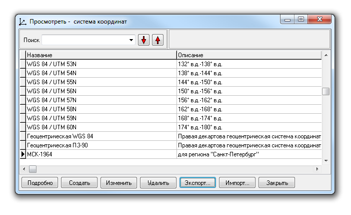
After enabling the module, the window appears:
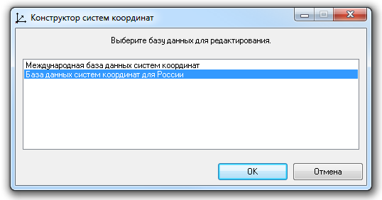
In this window, select one of the two default databases containing coordinate systems. In our case, we are creating a local coordinate system for one of Russia's regions, so we choose "Coordinate System Database for Russia." Click "OK."
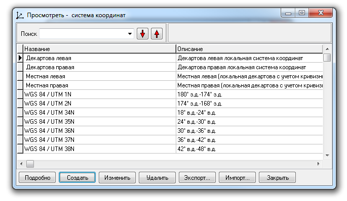
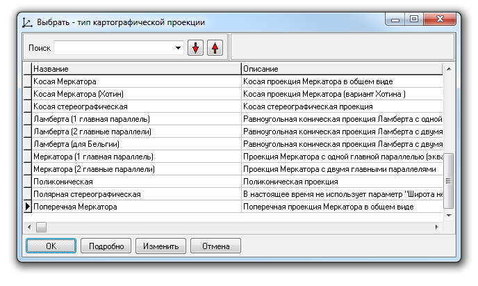
A list of coordinate systems possible for use with territories belonging to the Russian Federation appears. Later, our created coordinate system will be reflected in this list. Choose the "Create" option.
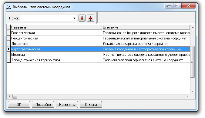
Creating a coordinate system starts with selecting the type of coordinate system. Local coordinate systems for Russian regions are flat rectangular coordinate systems in Gauss projection with a local coordinate grid. Therefore, such coordinate systems are classified as cartographic. Accordingly, in the list of coordinate system types, select "Cartographic" and click "OK."
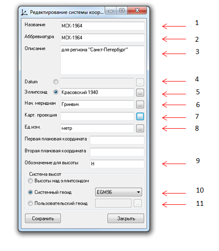
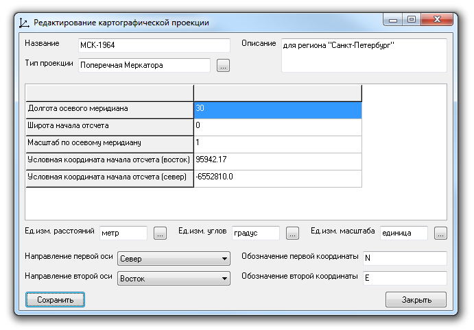
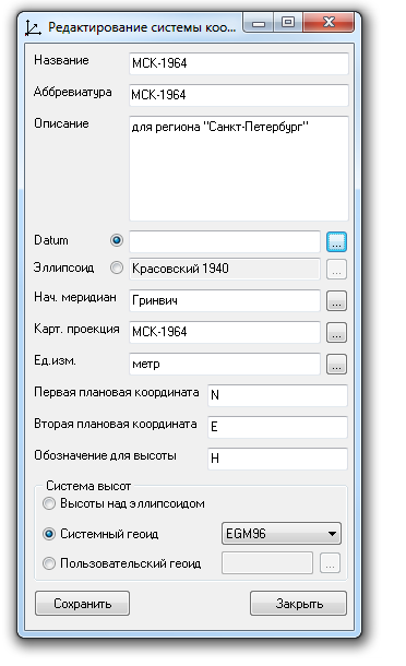
The "Edit Coordinate System in Cartographic Projection" window appears. In this window, perform the following:
1. Name. Enter the full name of the MSK being created.
2. Abbreviation. Enter the short name of the MSK being created.
3. Description. Enter summary information about the purpose of the MSK.
4. Datum. In this case, we use the Krasovsky 1940 ellipsoid, so there is no need to use a datum.
5. Ellipsoid. To the right of the white field, click the "..." button and see the window:
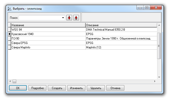
In this window, select the ellipsoid required for creating the MSK. This is the Krasovsky 1940 ellipsoid. Click "OK."
6. Prime Meridian. Leave Greenwich as default. It is used in the vast majority of coordinate systems. The MSK being created is no exception.
7. Cartographic Projection. An important point, we will return to it shortly.
8. Unit of measurement. In MSK for Russian regions, the metric system is used. Therefore, leave the meter as default. But if you click "..." to the right of the corresponding white field, you will get the window:
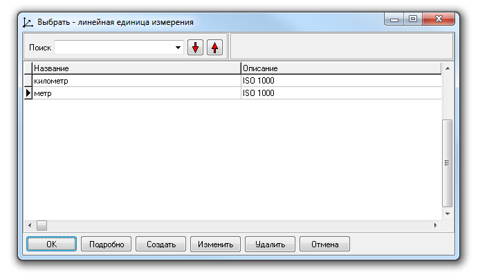
As you can see, this window allows you to choose linear units of measurement such as kilometers and meters. Using kilometers as a linear unit of measurement is more convenient when working with low-resolution and medium-resolution images, close to low resolution, as well as with cartographic materials of small scale. In our case, we use meters as the linear unit of measurement.
9. Height designation. By default, the standard notation for height in geodesy and cartography is retained.
10. Height System, system geoid. Experience in creating digital terrain models, orthotransformation of satellite images, and performing other tasks shows that height values obtained from quasi-geoids such as EGM96 or EGM2008 allow solving technical tasks most accurately for most regions of the Earth, unlike height systems above the reference ellipsoid. Therefore, if there is any system geoid in the PHOTOMOD5 database, it is recommended to use it. PHOTOMOD5 software is supplied by default with the EGM96 system geoid. Choose it.
11. Height System, user geoid. In cases where there is any proprietary quasi-geoid that describes in detail the height system for the area where the MSK is used, this option can be used to load it into PHOTOMOD5.
Returning to the cartographic projection.
Click "..." to the right of the white field in the "Cartographic Projection" row and see the following window:
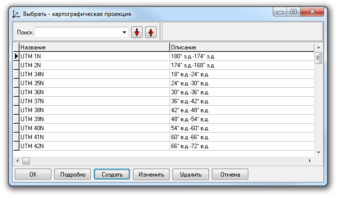
In this window, select "Create." Move to the window:
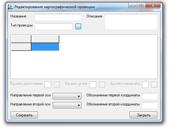
In this window, click "..." to the right of the white field in the "Projection Type" row.
Next, enter the name of the new cartographic projection in the previous window (for convenience, make it the same as the created cartographic coordinate system). Provide a brief description of the purpose of the cartographic projection for the future. Then, enter the parameters of the projection in the five lines that appear corresponding to the MSK. Just below the parameters, specify the directions of the coordinate grid axes of the projection, symbolic representations of coordinates, and units of measurement in which the parameter values were recorded. See the description of MSK parameters in the article "PARAMETERS OF MSK AND THEIR USE IN QGIS and PHOTOMOD5". Then click "Save."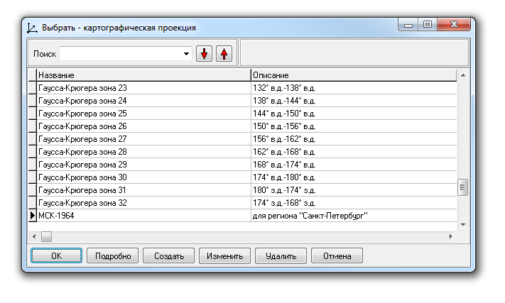
Now the created projection for MSK-1964 is available in the list of cartographic projections. Select it and click "OK."
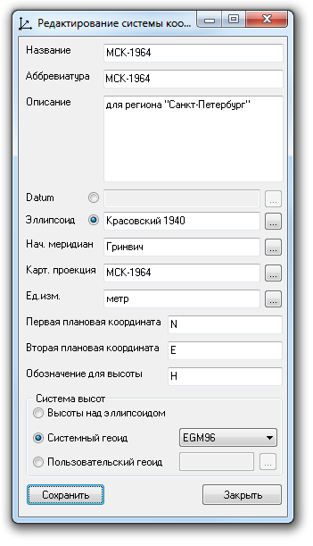
The entry "MSK-1964" appears in the "Cartographic Projection" row. Click "Save."
In the coordinate system database for Russia, the MSK-1964 coordinate system has been added. This coordinate system is now available for use on the photogrammetric station (PC operating system) where it was created. If necessary, it can be exported and transferred for use on another photogrammetric station (another PC).
2. MSK-1964 GOST 51794-2008
The principle of creating the MSK according to GOST 51794-2008 is similar to the previous example. The difference lies in the fact that for refining the position of objects in the MSK for regions, a datum computed for the shift and transformation of the Krasovsky 1940 reference ellipsoid is used.
Let's look practically at the stage when we use the datum.
In the "Editing Cartographic Projection Coordinate System" window, instead of the Krasovsky ellipsoid, select Datum. Click the corresponding "..." button.
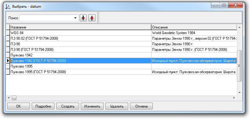
In the list of calculated datums for MSK-1964, simply select "Pulkovo 1942 (GOST 51794-2008)" and click "OK" to activate the shift and transformation parameters.
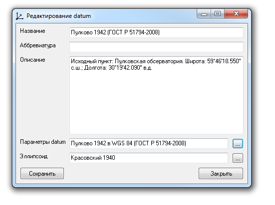
But to understand which parameter values are included in this item, you need to click "Edit" and go to the selected datum window.
Next, click "..." in the "Datum parameters" row. You will enter the "Datum Transformation" window.
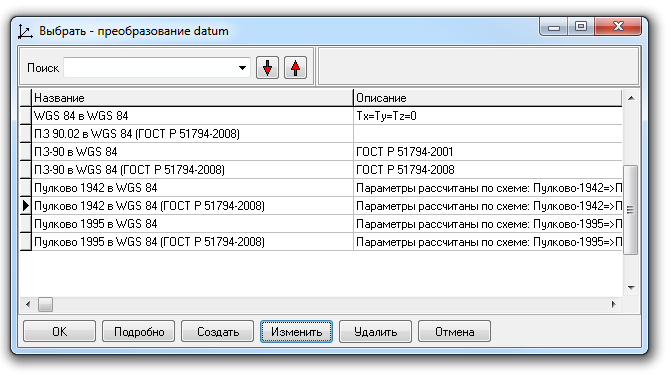
Again, select the desired datum and click "Edit."
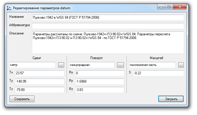
Now you are in the datum parameter editing window. Here you can verify the shift and transformation parameters of the reference ellipsoid and make corrections if necessary.
Remember, it is necessary to compare the parameters of the created MSK with the pre-calculated parameters available in PHOTOMOD5 to understand for which original coordinate system the datum was obtained (SK-1942 or SK-1995) and exclude an error in its determination.
You can order from us


Sat-Sun: Non-working days