Contact

Earth observation data for organisations holding subsoil use licences: control, monitoring and protection of assets from space

01

Introduction: A New Reality for Subsurface Users

Introduction: A New Reality for Subsoil Users

Since 2025, satellite imagery has become an official tool of state geological supervision in Russia. Rosprirodnadzor, Rosnedra, and Rostekhnadzor use Earth observation (EO) data to assess compliance with license terms — without on-site inspections and without prior notice. From 2022 through October 2025, more than 85% of violations across 15,500 subsoil sites were identified using EO data.

For organizations holding licenses for mineral extraction, geological exploration, or mineral prospecting, this means one thing: the government is already monitoring your site from space. The question is whether you are doing the same.


02

Three key scenarios for the use of Earth Observation data by a subsoil user Scenario 1. Preventive audit of a licence area

Why This Matters Right Now

Regulatory Pressure Has Reached a New Level

As of 2026, 592 subsoil use licenses are in effect in the Khanty-Mansi Autonomous Okrug–Yugra alone. Across Russia, there are tens of thousands of such licenses. In 2025, Rosprirodnadzor monitored compliance with obligations under 1,577 licenses that were due to expire that year. Among the inspected sites:

● only 1.5% (18 out of 1,173) met all safety and environmental protection requirements;

● 26.5% (310 licenses) were classified as “dormant,” with no signs of mining activity;

● 44% (511 sites) had their licenses revoked due to failure to fulfill reclamation obligations.

The total amount of administrative fines imposed as a result of geological supervision in 2025 reached RUB 79.2 million.

Penalties for Violations

Subsoil use without a license or in violation of license terms may result in the following administrative fines for legal entities:

 Violation

 Fine for Legal Entities

 Subsoil use without a license

 RUB 800,000–1,000,000

 Violation of license terms / approved technical project

 RUB 300,000–500,000

 Failure to comply with an official order

 up to RUB 1,000,000 or more

In addition to fines, violations may result in license revocation and claims for compensation for environmental damage — amounts that are incomparable to the preventive costs of monitoring.

What the Government Sees — and What You Should See

The methodology used by regulatory authorities is simple and transparent: an inspector obtains up-to-date satellite imagery, overlays the coordinates of the licensed area, and compares the actual locations of mining operations, waste dumps, and infrastructure facilities with the approved project documentation.

Earth Observation Data Can Reveal:

● mining operations extending beyond the boundaries of the licensed area (unauthorized subsoil use);

● extraction activities within areas licensed solely for geological exploration;

● discrepancies between the actual locations of mine workings and waste dumps and those specified in the approved project documentation;

● failure to use overburden materials for their intended purpose;

● unauthorized disposal of subsoil use and mining waste;

● absence of reclamation measures or improper land reclamation.


03

Why remote sensing data is an investment rather than an expense

Three Key EO Use Cases for Subsoil Users

Scenario 1. Preventive Audit of a Licensed Area
bc3e1b67-c01a-40e9-af9b-23d1629ea140.png


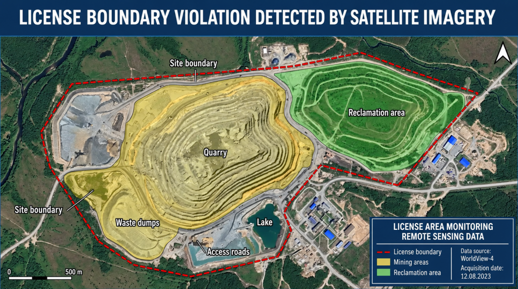
Example: overlaying the boundaries of a licensed area on up-to-date satellite imagery can reveal mining operations extending beyond the permitted zone before this is detected by an inspector.

Objective: to ensure that actual operations comply with the license terms and the approved technical project before an inspection by regulatory authorities.

High-resolution satellite imagery (0.5–2 m/pixel) makes it possible to determine with sub-meter accuracy:

● the boundaries of open-pit workings and compare them with licensed coordinates;

● the location of overburden dumps;

● the presence and condition of reclaimed areas;

● the condition of infrastructure facilities (roads, pipelines, industrial sites).

● Client benefit: timely detection of deviations, the ability to remedy violations before an inspection, and avoidance of fines of up to RUB 1 million.

Scenario 2. Regular Monitoring of an Oil & Gas or Coal Field
76b9c6e9-5c7e-45b3-8685-afce27a76b64.png


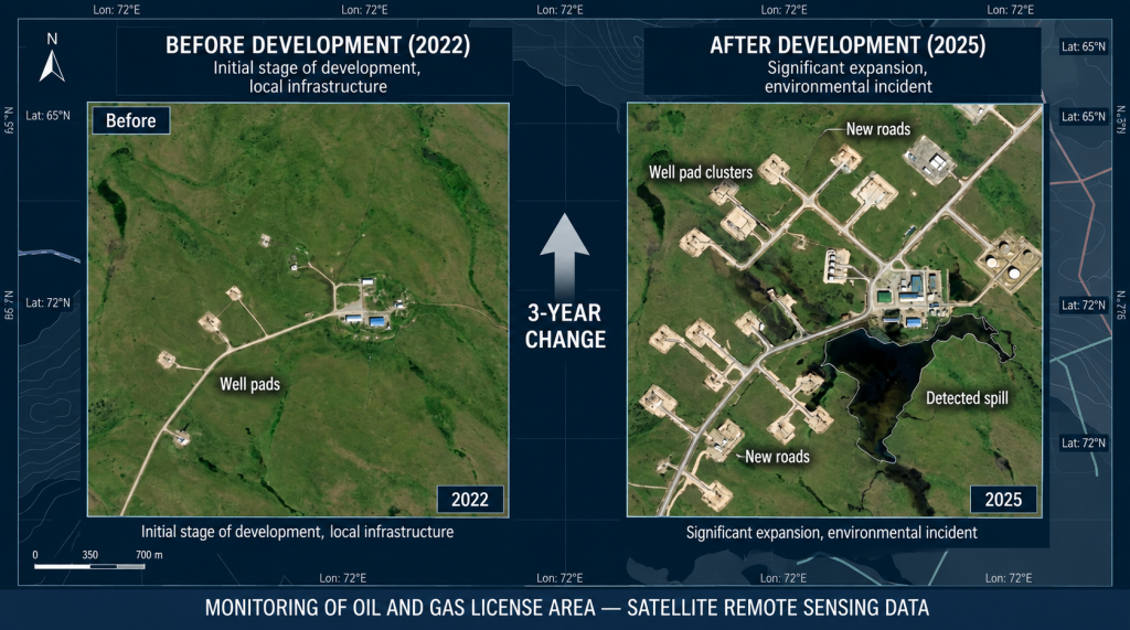
Comparison of imagery acquired at different times makes it possible to track the expansion of well pads, infrastructure development, and the environmental condition of the area.

Objective: to monitor changes in economic activity within an active licensed area throughout the entire license term.

Regular acquisition of imagery on a quarterly or monthly basis enables systematic assessment of site conditions and provides an objective evidence base demonstrating responsible subsoil use in communications with regulatory authorities.

Applications in the oil and gas industry:

● mapping of field development facilities;

● detection of petroleum product spills;

● monitoring the condition of pipeline protection zones;

● updating road networks and planning logistics;

● assessment of changes in shorelines and wetlands.

Client benefit: a documented history of compliance with license conditions, reduced regulatory risks, and an information base to support license renewal.

Scenario 3. Reclamation Monitoring and Preparation for License Closure
c9366a8c-9d6a-4f8d-a438-1d49499b31e2.png


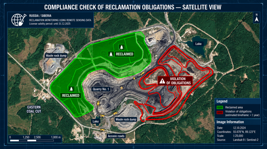
Objective: to confirm fulfillment of obligations to reclaim disturbed land as a mandatory condition for license renewal or closure.

Reclamation of subsoil areas granted for use is a mandatory condition for license renewal. In 2025, 44% of the inspected sites had their licenses revoked specifically due to failure to comply with this requirement.
Multispectral imagery makes it possible to monitor the condition and recovery dynamics of vegetation cover and assess the quality of reclamation activities.

EO data for reclamation monitoring:

● NDVI analysis to assess vegetation condition and recovery;

● detection of contaminated areas;

● long-term monitoring of vegetation establishment and survival;

● creation of a photographic evidence base for formal handover of the site to the regulator.

Client benefit: confirmation of compliance with license obligations, minimization of the risk of license revocation, and reduced exposure to environmental claims.

Forest Management within a Licensed Area: Requirements of Clause 63 of the Forest Management Instruction

Most licensed subsoil areas in Russia are located within forest fund lands. Under Article 72 of the Forest Code of the Russian Federation, subsoil users are required, at their own expense, to carry out forest inventory and design measures for forest conservation within the forest area granted to them.

This means that the license holder becomes the customer for forest management works, and the EO materials used for these purposes must comply with specific regulatory requirements.

Clause 63 of the Forest Management Instruction (Order No. 510 of the Ministry of Natural Resources and Environment of the Russian Federation dated 05.08.2022, effective until 01.03.2029)

Clause 63 establishes minimum spatial resolution requirements for EO materials depending on the type of forest management activity:

 Forest Management Activity

 Required EO Spatial Resolution

 Forest district planning

 no worse than 2.5 m/pixel

 Planning of production, protective, reserve forests and specially protected forest areas

 no worse than 2.5 m/pixel

 Forest inventory: visual-instrumental and visual assessment methods

 no worse than 2.5 m/pixel

 Forest inventory: analytical-instrumental interpretation, automated processing, and rational combinations of methods

 no worse than 1 m/pixel

 Planning of forest conservation measures

 no worse than 2.5 m/pixel

In addition, Clause 62 establishes a requirement for the georeferencing accuracy of EO materials relative to ground control points: no worse than ±5 meters.

Practical Implications for Subsoil Users

To fulfill mandatory forest management obligations within a leased forest area, a subsoil user may independently procure and use satellite imagery, provided that its technical characteristics comply with Clause 63 of the Instruction. This makes it possible to combine two mandatory processes:

1. Forest management (forest inventory and planning of forest conservation measures) — imagery with a spatial resolution of ≤ 1 m/pixel is required for analytical-instrumental interpretation;

2. Monitoring compliance with subsoil use license conditions — up-to-date high-resolution imagery covering the licensed area is required.

A single, properly selected and technically accurate georeferenced satellite image can satisfy both requirements at the same time.


Why EO Data Is an Investment, Not an Expense

The government is already investing billions of rubles in space-based monitoring infrastructure: in 2026, RUB 5 billion was allocated to government customers for the procurement of Earth observation data. Roscosmos, Rosprirodnadzor, and Rosnedra are systematically building a comprehensive remote monitoring system for subsoil use sites.

For organizations holding subsoil use licenses, the logic is simple:

A single satellite image ordered at the right time costs hundreds of times less than the minimum fine for violating license conditions.

Preventive monitoring of your own licensed area is not an optional service, but an essential element of risk management in an environment where government authorities systematically use EO data to identify violations.

What We Offer

GEO Innoter supplies data from leading commercial Earth observation satellites and provides a full range of analytical services for subsoil users:

● Archive and newly acquired imagery with spatial resolution from 0.3 to 2.5 m/pixel, compliant with the requirements of Clauses 62–63 of the Forest Management Instruction (Order No. 510 of the Ministry of Natural Resources and Environment);

● Geospatial audit — overlaying license boundaries on up-to-date satellite imagery and performing a comparative analysis against project documentation;

● Regular monitoring of licensed areas with customizable frequency (monthly / quarterly / annually);

● Thematic maps and reports for submission to regulatory authorities;

● Multispectral analysis for assessing reclamation progress, environmental conditions, and geological anomalies;

● Selection of imagery for forest management purposes — EO materials with documented metadata confirming spatial resolution and georeferencing accuracy for inclusion in forest management documentation.

Contact us to receive a test image of your site and a commercial proposal.


clients who trust us
25+ years in the geodata market
clients who trust us
25+ years in the geodata market
Request a call back
Back to page top
Мы используем Яндекс.Метрика и собственные Сookies для обеспечения наилучшего опыта работы на нашем сайте, персонализации сайта для наших пользователей и аналитики. Продолжая использовать сайт вы соглашаетесь с условиями Пользовательского соглашения.