Sat-Sun: Non-working days
Abstract
The article explores the potential of using aerospace imagery in judicial and pretrial disputes as an objective means of confirming the situation on the ground at a specific date. Examples are provided of applying geospatial methods to collect evidence for resolving conflict situations, including land and property disputes.
Introduction
Land disputes are conflict situations between landowners and the state or third parties regarding the ownership, use, and disposal of land plots.
The subject of a land dispute can include any conflict related to a land plot, its boundaries, size, location of immovable property on it, etc.
The difference between land disputes and land-property disputes lies in the fact that land disputes pertain to the violation or contestation of citizens' or legal entities' rights to land plots, usually without a significant financial interest. Such disputes often involve issues like boundary disputes, land plot sizes, or removal of barriers to land use.
Land-property disputes, on the other hand, are disputes concerning land plots that also require determining rights to other properties. For instance, disputes over the use or division of a land plot among co-owners of residential buildings or structures, or determining rights to land plots occupied by immovable property essential for its use.
Land and land-property disputes can arise from various causes, and their complexity often depends on numerous factors. The main causes of land disputes include:
- Unclear or inconsistent boundaries of land plots, lack of proper documentation on ownership rights, and disputes among multiple owners over inheritance rights.
- Incorrect data in land documents, errors in cadastral records, duplicate or invalid transfer deeds.
- Changes in zoning and land use, government decisions affecting land use (e.g., for construction, agriculture, etc.).
- Illegal land occupation (unauthorized construction, land grabbing), violations of tenants' or owners' rights, such as resale or misuse of land.
- Conflicts between neighbors over shared infrastructure or resources, disputes over land valuation during transactions, assessments, or taxation.
- Inheritance disputes over land plots, contested wills, or claims not adhering to legal norms.
- Conflicts regarding the location of infrastructure (roads, power lines) on privately used lands.
- Disputes among family members during divorce proceedings.
Remote sensing data is increasingly used for resolving disputes, both in court and pre-trial settings.
Remote sensing involves collecting information about objects and phenomena using recording instruments that do not directly interact with the objects or phenomena being studied.
Data obtained through remote sensing can serve as a primary source of information in evidentiary analysis.
When using satellite imagery as evidence in court, the following aspects are particularly important: verified date of capture, confirmed coverage within the research object's boundaries (e.g., cadastral number), and expert conclusions about the presence or absence of specific objects or phenomena. These factors help the court understand the circumstances, timing, and condition of the objects in question.
Numerous examples from judicial expert practice demonstrate the effectiveness of this method, which allows for non-contact surveys of objects over extensive areas, significantly reducing the time and costs of conducting expert analysis.
This method enables experts to conduct retrospective analyses of landscape changes using advanced software for image processing, allowing for both visual and automated analysis. Automation helps eliminate subjectivity in image interpretation, which is critical for producing substantiated expert conclusions.
The experience of using satellite imagery in judicial expertise shows that such images, while serving an illustrative function, also carry substantial informational value. This includes measuring various metric characteristics of the examined object and assessing its qualitative and quantitative changes over time. This applies to both immovable and movable property.
There is positive practice in using satellite imagery and expert conclusions as evidence in courts and pre-trial proceedings.
The simplest form of expert opinion is an accompanying letter specifying all the capture parameters and attaching a printed satellite image with a coordinate grid. Such images can also be notarized. However, these conclusions may not always be accepted by the court, potentially leading to rejection. Relying on luck in such matters is not advisable.
Additionally, clients may not always be able to correctly interpret remote sensing materials or include details in the image description that they are aware of but are not visible or identifiable on the image.
One of the main advantages of remote sensing data is its objective representation of the terrain. Such data is invaluable for defending land rights and resolving land disputes. Moreover, archived remote sensing data is often indispensable for studying hard-to-access areas.
Legal Framework for Judicial Land and Land-Property Expertise
Expert activities are carried out in strict compliance with current legislation.
According to the procedural legislation of the Russian Federation, judicial expertise can be conducted outside state judicial-expert institutions by individuals possessing specialized knowledge in science, technology, art, or craft, even if they are not certified state judicial experts.
The specifics of appointing and conducting judicial expertise within legal proceedings are regulated by relevant articles of procedural codes, as well as other legislative acts.
Goals and Objectives of Judicial Expertise
The primary issue addressed during expertise utilizing remote sensing (RS) data is the insufficiency of admissible and reliable evidence for legally significant periods.
RS Data for Resolving Land and Land-Property Disputes
To resolve disputes involving the use of satellite imagery, we have access to original data from over 60 satellites worldwide, collected since the 1970s. Each image comes with its "passport" (metadata files), containing all the unique information about the image.
Projects of "Geospatial Agency Innoter" in Resolving Land and Land-Property Disputes
Let's look at the experience of the company accumulated over many years of conducting expert assessments.
The most common type of work in this area is determining the date of construction of a building or structures.
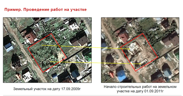
Example 1 - Determining the Date of Construction of a Building.
A client contacted us for help during a divorce process. The client wanted to prove that the construction of the house began before the marriage. Two satellite images from 2009 and 2011 were analyzed.
On this slide, we see that before September 2009, the site was almost empty (a probable foundation outline is visible in the southeastern part of the site). By September 2011, construction work was already actively underway (a probable residential building is clearly distinguishable in the northwestern part of the site, and the walls of the building under construction have already appeared in the southeastern part).
With the help of our expertise, the client was able to prove that the construction of the house began before the marriage.
Another example of using satellite imagery is determining the absence or presence of a structure on a land plot.
Example 2 - Determining the Absence or Presence of a Structure on a Land Plot.
We were contacted by the Ministry of Internal Affairs of the Russian Federation regarding the misuse of budget funds allocated for work.
In early 2015, a tender was held, won by an individual entrepreneur. The winner was supposed to use the allocated budget to build an animal shelter measuring 20x20 meters. According to the contractor's report, the shelter was built by May 2016, and a log cabin measuring 3.5x3.5 meters with a wooden annex was installed and dismantled by May 2017 as unnecessary.
Our experts conducted an examination using two satellite images from August 7, 2016, and February 16, 2017.
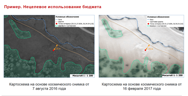
Based on satellite image interpretation, no anthropogenic objects were found on the site of interest. The nearest anthropogenic object is a dirt road 25 meters from the original point where the shelter was supposed to be located.
Considering that the spatial resolution of satellite images is 0.5 m, it is impossible for an animal shelter with an area of 400 m² (20x20 m) and a log cabin with an area of 12.25 m² (3.5x3.5 m) to be indistinguishable on satellite images.
Thus, the individual entrepreneur who carried out the work faces criminal liability, and the investigator received a promotion for solving the fraud case.
Example 3 - Determining the Absence or Presence of a Structure on a Land Plot at a Specific Date.
Another example from our practice:
A client contacted us for help during a divorce process.
The structure was built before 2012 and did not change its configuration until 2023. The other party claimed that the structure was demolished in 2014 and rebuilt during the marriage. As evidence, they provided a cadastral engineer's inspection report stating that on March 28, 2014, the object did not exist on the land plot.
In the archive of satellite imagery operators, there was an image from March 29, 2014, showing that the structure was standing. It is highly unlikely that such a structure could have been erected in one day.
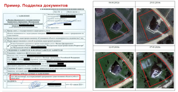
This slide shows a statement to the Rosreestr branch, where the party attached the inspection report.
Nearby are satellite images from June 4, 2012, March 29, 2014, May 12, 2018, and September 7, 2020, used for the study, showing that the structure did not change its configuration. With such evidence, the issue was resolved out of court.
Example 4 – Documenting Changes on the Ground on Specific Dates.
The client was accused of not dismantling a crane on time and fined for its downtime.
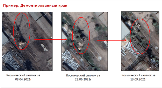
Analyzing archival data from 2021 (April 8, 2021, and June 23, 2021), one can see that the crane was present (based on direct interpretation signs, the object's shadow, and crane tracks) and even moved along the crane tracks. Analyzing satellite images from June 23, 2021, and September 13, 2021, one can conclude that the crane and its tracks were dismantled between June 23, 2021, and September 13, 2021, consistent with the contract terms. This helped the client prove that the contract terms were met and avoid a fine.


