Monitoring of oil pollution in the waters of seas and oceans
Offshore areas are directly involved in the oil and gas complex. Many large fields are located in the offshore zone of the seas, some modern oil pipelines run along the seabed, and offshore transportation is the second largest in terms of volumes of transported raw materials. Unfortunately, accidents and associated oil spills have been and remain inevitable companions of many offshore and onshore oil production, transportation and storage operations.
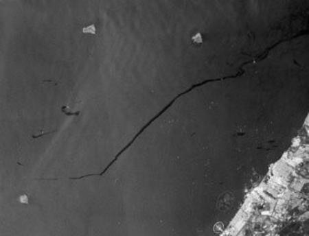
The causes and severity of oil spills vary depending on the combination of many circumstances, but unequivocally they all cause hardly repairable damage to the marine ecosystem. In the last 20 years alone, more than 10 major disasters have occurred, resulting in the release of more than 20 million tons of oil into the world's oceans. In addition, during the production process oil gets into the sea by natural seepage; during regular tanker operations (pouring and discharging oil) up to 36 thousand tons of oil per year are leaked, and during transportation some tankers dump spent fuel into the sea in order not to pay for the processing of the material.Fig. 1 Oil plume on radar image
Remote sensing method of ecological monitoring of water areas
At present, monitoring of sea water areas and coastal territories by remote sensing is the main method of controlling their ecological state. The method is based on receiving and processing images and other digital data from various systems on both foreign and domestic satellites. Analysis of the received data allows to promptly and regularly determine the ecological state of water areas affected by pollution of various origins, to assess the scale and degree of pollution, to identify the processes that carry pollution across water areas, and sometimes to identify the direct perpetrators of disasters. The possibility to promptly and regularly observe the condition of large areas of water areas, as well as to conduct repeated monitoring of the same places with a short interval of time makes space imagery data the cheapest, fastest and most objective remote method of environmental monitoring of water areas of seas and oceans. Let us consider the possibilities of radar data application for ecological monitoring. Nowadays radar survey is the main method of remote monitoring of both processes occurring in the ocean and processes between the ocean and the atmosphere.
Radar survey has a number of significant advantages of obtaining information on the state of the seas:
round-the-clock monitoring, with image quality independent of the time of day;
possibility to conduct monitoring in any weather, in particular in 100% cloudiness;
interpretation of radar images of water surface is quite simple due to the homogeneity of dielectric properties of water in the given spectrum range.
Radar monitoring
The method of monitoring the Earth's surface using radar imagery is based on the measurement of reflected radiation. During ocean surface monitoring with radar imaging, data on surface characteristics are contained in the reflection function, which is in the form of an electromagnetic wave reflected from the sea surface. The reflection function is formed not only by the properties of the surface itself, but also by the conditions of its formation. The image of the sea surface on the radar image depends on the range of imaging, polarization of radiation and the angle of signal incidence.
Depending on the receiver design and operating mode, radar systems can radiate and receive:
Depending on the receiver design and mode of operation, radar systems can radiate and receive:
on vertical polarization (VV);
horizontal polarization (HH);
dual polarizations (VH and HV).
Vertical polarization is used to study various processes and phenomena manifested on the sea plane by modulating the gravitational-capillary component of the surface wave spectrum.
Ice monitoring
Horizontal polarization, being less sensitive to variations in the fine-scale roughness of the sea surface, is widely used for sea ice monitoring and separation of radar images of ice cover and open water.
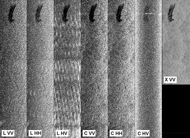
Since the intensity of signal reflection by the sea surface is significantly reduced when using radiation and reception in dual polarizations (VH and HV), such modes are used to detect objects capable of multiple reflections on the sea surface, such as ships and ice sheet deformations (hummocks, cracks, split ice).Figure 2 Comparison of different polarization and imaging range for oil spill detection
The radar imaging signal is able to penetrate into water only a few millimeters, but the processes occurring in the sea are determined by means of surface manifestations. Therefore, radar space images of water areas surface carry information about processes occurring not only in the surface layer, but also at a certain depth.
The radar signal reflected from the water surface depends on short gravity-capillary waves on the sea surface created by the wind. Atmospheric and oceanic processes create these gravity-capillary waves in one way or another, which manifests itself in different radar signal intensities. Various structures on the sea surface become observable precisely due to one or another mechanism of wave modulation, mainly due to currents and foreign substances on the sea surface that affect the surface tension of the liquid. Thus, radar imaging of the surface of water areas allows visualizing processes both in the ocean itself and in the atmosphere above it.
The advantage of radar data
A huge advantage of the radar signal over electromagnetic waves from other bands of the spectrum is that it penetrates cloud cover, providing 24/7 all-weather ocean observation. Another advantage of ultra-high-frequency radio waves, which is important for remote ocean diagnostics, is that these waves interact resonantly with the short-wave component of the surface wave and thus visualize movements in the ocean that are inaccessible for observation in other bands of the electromagnetic spectrum.
The effectiveness of space-based remote sensing applications depends to a greater extent on properly constructed models linking the characteristics of the microwave radiation received by a satellite instrument with the parameters of the sea surface and the atmosphere above it.
The main interest of remote sensing is focused on the areas of the sea surface covered with oil films - film slicks. The presence of an oil film on the ocean surface leads to a decrease in the intensity of water-atmosphere interaction and to a decrease in the resonant gravitational-capillary component of the surface wave. In this case, smoothed areas are formed on the ocean surface, which appear on the radar image as areas of reduced reflection that can serve as indicators of surface pollution.
Radar images of hydrocarbon spills on the sea surface depend on external conditions. The contrast between the spill area and the surrounding surface is determined by a number of parameters: wind speed, wave height, quantity and type of oil spilled. The shape of the spill is different between oil released from a stationary and a moving object. The behavior of oil spilled on the sea surface can be highly variable. Crude oil spreads over the sea surface to form a slick - a 'smoothed' area. In controlled spill experiments, it has been found that more than 90% of the oil remains in a relatively small central area for long periods of time, the area of which increases in proportion to time.
Surface wind is the most important factor in correctly identifying and assessing oil contamination on the sea surface from radar images. At wind speeds above 9-10 m/sec. film contamination of any origin, both oil and biogenic, is indistinguishable on radar images of the sea surface.
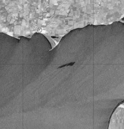
Ecological monitoring of oil pollution of water areas has shown its economic efficiency. The cost of ecologists' travel by ship or helicopter is several times higher than the cost of any kind of space survey. Besides, the ship itself is a source of sea surface pollution. Operational control of large oil spills allows to accurately delineate the spill zone and urgently start measures to prevent its further spread. This means that pollution will not affect the sea shores, coastal flora and fauna will not be destroyed and, consequently, economic costs will be reduced.Fig. 3 Oil spill on the sea surface on the radar image
Causes of oil spills
The causes of oil spills on the sea surface can vary. The worst variant is man-made accidents in the places of extraction and during transportation by oil tankers. It is the worst because the oil spill into the sea area is massive and simultaneous, instantly killing all living things around and leaving no time to take action.
Another way of pollution is the release of oil products during the drilling of a well on the shelf and its further operation. In this case, spills are kept under control and allowed to float far away from the production sites. Oil products also get into the sea due to negligence of sea vessels' crews. By accident or on purpose, they pour spent fuel into the ocean to avoid paying for waste disposal.
To be fair, it should be noted that some of the oil gets into the world's oceans naturally - through seeps in the oceanic crust. This in turn can signal oil exploration.
To identify oil contamination in your area of interest, contact Innother, the leading company in the application of remote sensing data in the oil and gas industry. Contacts: +7 (495) 245-04-24, innoter@innoter.com.