01
What is the benefit of this article?
The Forest Management Instruction (Order No. 510 of the Ministry of Natural Resources and Environment dated 05.08.2022, as amended on 18.06.2026, with the amendments taking effect on 01.03.2027) (hereinafter referred to as the “Instruction”) explicitly states that satellite imagery forms the basis for all forest management activities. This is not a recommendation, but a mandatory requirement. Without satellite imagery, forest management documentation will simply not be accepted.
Clause 63 of the Instruction establishes the minimum imagery quality requirements:
● For most types of work — spatial resolution no worse than 2.5 meters per pixel
● For detailed forest inventory (determining forest composition and condition) — no worse than 1 meter, with stereo imagery required
● Imagery must be acquired only during the period when foliage is fully developed (June–August, depending on the territory)
● Image age — no more than 3 years at the start of the work
● The imagery must be cloud-free over your area
This may sound technical, but in practice it means one thing: you need up-to-date, clear imagery acquired during the appropriate season. The rest is a task for specialists.
Satellite imagery is useful not only for forest management. In practice, lessees use it in four main situations.
Forest management and forest inventory. Using satellite imagery, specialists determine tree species composition, forest age and condition, and map the boundaries of compartments and forest stands. This forms the basis of all forest management documentation.
Monitoring your own area. Regular imagery records what is happening within your territory: where logging is taking place, where unauthorized access roads have appeared, and where the forest has been damaged.
Documenting completed work. A dated satellite image provides evidence that sanitary logging, planting, firebreak plowing, or clearing operations were completed on time. This can protect you during inspections.
Disputes. If someone has illegally logged timber within your area or you have been issued an unjustified fine, archive imagery can help reconstruct what happened and support your position.
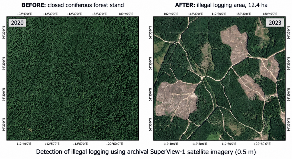
A forest lessee in Siberia contacted us after discovering fresh stumps and skid trails during a site inspection in a compartment where no authorized logging had been carried out during that period. The task was to determine the volume of timber removed and the period during which the illegal logging occurred.
Two archive SuperView-1 images with 0.5 m resolution were selected for analysis — one acquired before and one after the detected violation. In the earlier image, the area was covered by a closed coniferous forest canopy (canopy closure 0.8). In the later image, logged areas, skid trails, and piles of logging residues were clearly identifiable within the same zone.
Based on the measurements, the area affected by illegal logging amounted to 12.4 hectares. The presence of skid trails and the logging pattern indicated selective sanitary logging carried out without the required permits.
Using the expert assessment materials, the lessee filed complaints with Rosleskhoz and the prosecutor’s office. The responsible party was identified, and the damages were recovered in full. The cost of the expert assessment was less than 1% of the amount recovered.
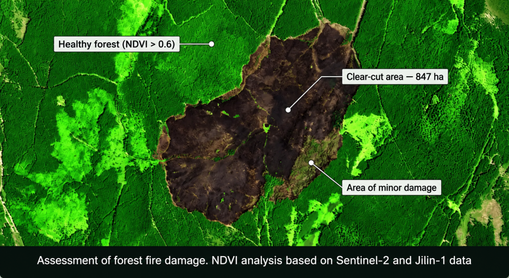
A forest lessee in Central Russia faced a situation in which a surface fire passed through the leased territory. The regional forestry department initiated an administrative claim for inadequate forest protection and demanded compensation for the resulting damage.
The lessee had records showing that fire prevention measures had been carried out — including firebreak plowing and the establishment of mineralized strips — but there was no documentary evidence confirming that the work had actually been completed.
Our experts performed a retrospective analysis using archive Jilin-1 imagery with 0.75 m resolution. In an image acquired before the fire, perimeter plowing and mineralized strips along compartment boundaries were identified. NDVI analysis of Sentinel-2 multispectral data showed that the fire had spread from an adjacent area that was not under lease, while the lessee’s fire protection infrastructure at the points where the fire crossed the boundary had already been damaged before the start of the season — which was also confirmed by satellite imagery.
Following review of the evidence, the claim was fully withdrawn, and responsibility for the damage was divided between the lessee and the regional forestry authority due to inadequate monitoring of the adjacent territory.
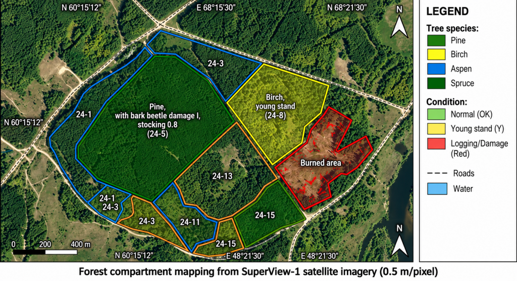
A major forest lessee in the Vologda Region was carrying out a scheduled update of forest management materials that were approaching 10 years of age. Sending field crews to survey the entire 84,000-hectare area would have required significant time and budget.
The task was solved using a combined approach: multi-temporal Jilin-1 imagery (0.75 m) and Sentinel-2 multispectral data (10 m) were used for preliminary desktop classification to identify areas that had changed since the previous forest inventory, including clear-cuts, young stands, cluttered areas, and burned areas. Field crews were then sent only to the “changed” forest stands (approximately 18% of the total area) for on-site inspection, while the remaining area was updated using analytical-instrumental image interpretation.
The overall savings on fieldwork amounted to approximately 40% of the estimated cost, while the results complied with all requirements of Clause 63 of the Forest Management Instruction.
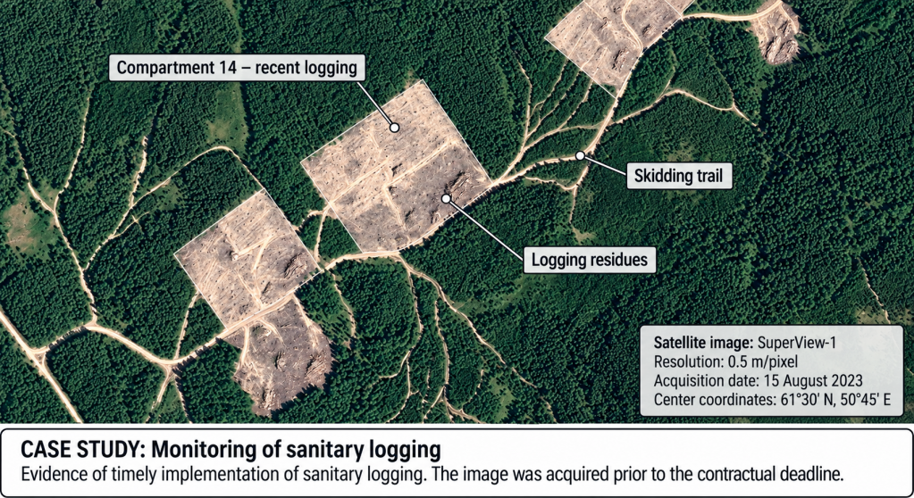
A forest lessee contacted us after a scheduled inspection, when forestry regulators requested proof that the sanitary logging operations required by the forest development project had been completed within the prescribed timeframe. Acceptance certificates had been prepared, but the inspectors questioned the actual date on which the work had been performed.
A SuperView-1 image acquired before the end of the contractual deadline was selected from the satellite operators’ archives. The image clearly showed fresh logging sites with logging residues and skid trails in the same forest compartments specified in the documentation.
The current satellite image, dated before the end of the contractual deadline, became conclusive evidence that the work had been completed on time. The regulators’ claims were withdrawn without the need for court proceedings.
Not every satellite image is suitable for forest management. The following data are commonly used in practice:
|
Task |
Requirements |
Suitable Satellites |
|
Detailed forest inventory |
≤1 m, stereo |
SuperView, Jilin, Pleiades, WorldView, Beijing, Legion, BlackSky, Kompsat |
|
Forest management and updating |
≤2.5 m |
SPOT-6/7, GF/ZY series |
|
Preliminary change analysis |
10–20 m |
Sentinel-2, Landsat |
Open-source imagery such as Sentinel-2 is not suitable for forest management purposes because its spatial resolution does not meet the requirements of Clause 63. However, it is very useful for preliminary assessment: identifying what has changed and determining where higher-resolution imagery is required.
Preparation of satellite imagery materials is recommended to begin 3–6 months before the start of forest management activities.
The first step is to check whether archive satellite imagery is available that meets the requirements of the Forest Management Instruction and the technical specifications. In many cases, satellite operators already have imagery of the required quality in their archives, which can significantly reduce preparation time and project costs.
If suitable archive data are unavailable or do not meet the requirements for acquisition season, spatial resolution, cloud cover, or other parameters, new satellite imagery should be ordered in advance. This is particularly important because new imagery can only be acquired under favorable weather conditions and when satellite orbits provide coverage of the area of interest.
The optimal period for acquiring imagery of forest areas is June–August, when woody vegetation is in full seasonal development.
During this period, tree species composition, forest health, damaged areas, burned areas, debris accumulation, and other characteristics required for high-quality forest management can be determined most reliably.
● Before starting the work, it is necessary to check the availability of suitable archive satellite imagery.
● If suitable archive materials are unavailable, new satellite imagery should be ordered in advance, preferably 3–6 months before the start of forest management activities.
● Satellite imagery is a mandatory component of the information base for modern forest management and enables compliance with applicable regulatory requirements.
● Archive imagery helps reconstruct the condition of forest areas on historical dates and is widely used in dispute resolution and expert assessments.
● Combined use of archive and newly acquired satellite imagery with different spatial resolutions improves interpretation quality and helps optimize the scope of fieldwork.
GEO Innoter has access to data archives from more than 100 Earth observation satellites. We can select imagery that meets the requirements of Clause 63 of the Forest Management Instruction and, where suitable archive imagery is unavailable, arrange new satellite acquisition within the optimal timeframe.