of geospatial solutions
Sat-Sun: Non-working days
The concept of Artificial Intelligence and Machine Learning (AI/ML), which helps analysts perform their work faster, is being discussed in the geospatial industry, but often only in the context of analyzing a single image. What happens when an analyst receives up to 15 images of the same area every day, while being responsible for monitoring multiple locations? With enormous volumes of geospatial data arriving daily, even an entire team of analysts cannot thoroughly examine all the details.
Using the analysis of a single satellite image as an example, we want to show you why artificial intelligence should become part of every analyst's workflow.
Scenario
At the beginning of the workday, the analyst receives a list of places to monitor and items to search for in various areas. Specifically, they need to monitor vehicles around the Hyundai plant in Ulsan, South Korea. Completed cars are stored in open areas and parked close to each other. The analyst needs to determine how many cars are in the parking lot and compare the count with previous days' inventories, analyzing an image from the Maxar WorldView-3 satellite with a resolution of 30 cm.
Manual Car Counting
When solving this task using manual counting, the following results were obtained. Analyst Adam counted 1117 cars, while analyst Joe counted 1129. The highly skilled data processing team that Joe works with recounted the cars and got different results again: 880, 883, 953, 1013, and 1049. Adam's mother and niece joined the counting and ultimately counted 1041 and 1182 cars, respectively. Each person spent between 20 to 30 minutes on manual counting.
There are reasons why the results always differed: some mistook shadows from cars for additional vehicles; others thought they saw part of a car or did not count a car because they mistook it for something else.
Let's take a look at the satellite image.
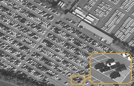
Scaling a fragment of an image often leads to quite a bit of debate. In this section of the parking lot, are there five cars or six? Some see a shadow between the light and dark cars on the right side of the image, suggesting there should be a car there. However, others argue that the parking lot is clearly empty. Such analysis is highly subjective, even when using a satellite image with the highest resolution of 30 cm. See what happens to the image when the resolution is reduced to 80 cm—it becomes increasingly difficult to distinguish individual cars, let alone shadows.


Counting Cars Using Artificial Intelligence on Satellite Images
An analyst has access to the Maxar machine learning database, which allows the development of algorithms for counting cars in satellite imagery. He runs an algorithm to analyze the same image with a resolution of 30 cm, examining one square kilometer in a fraction of a second. Instead of the average 25 minutes it took people to count, the algorithm generates its result in less than half a second: 1267 cars.

The value of artificial intelligence algorithms lies in providing answers 150 times faster than a single person, let alone the nine individuals who counted cars to obtain a median number.
The WorldView Legion data will compel analysts to utilize artificial intelligence for their needs. When Maxar launches these satellites in the first half of 2021, they will transmit up to 15 high-resolution images of the Earth's surface in a single day. An analyst won't have the time to manually count cars on each of these 15 images during one shift. However, there will be ample time to run all 15 images through the DeepCore car counting algorithm, obtain nearly precise numbers, observe trends in car counts, and investigate the reasons behind these changes, thus creating critically important insights to influence decisions.
One critical factor in relying on AI/ML to manage the influx of data from Maxar's expanded constellation is resolution. Just as humans had to judge whether they saw the sixth car or a shadow, algorithms must be trained to do the same. And when image resolution deteriorates, algorithms receive less information to work with. Check out the GIF to see how algorithm estimates change as resolution worsens.

As analysts have access to top satellite images, they will need to use AI/ML to effectively monitor multiple locations. That's why Maxar employs over 1,000 data processing specialists and geospatial analysts—to anticipate and solve complex client challenges.


Sat-Sun: Non-working days