of geospatial solutions
Sat-Sun: Non-working days
What is a four-channel image?
A four-channel image is a multispectral image obtained from several parts of the electromagnetic spectrum. The spectrum spans the entire range of light radiation from gamma rays to radio waves, including X-rays, microwaves, and visible light. A four-channel image delivered to the customer typically includes red, green, blue, and near-infrared (NIR) ranges. Only three bands can be viewed simultaneously in most software applications currently used. A GIS operator can choose to display the image in natural color (using the red, green, or blue bands) or in false-color infrared (using the infrared, red, and green bands).
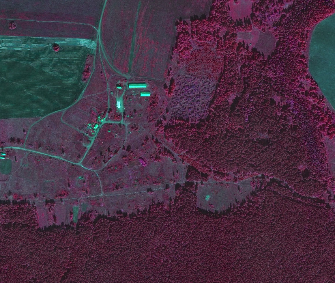
What is a color infrared image?
Color infrared (CIR) film is a three-layer product with individual layers sensitive to red, green, and near-infrared wavelengths. Near-infrared (NIR) wavelengths are slightly longer than red wavelengths and are outside the range visible to the human eye. Blue wavelengths, part of natural color film, are filtered out with CIR.
Obtaining a digital image requires charge-coupled device (CCD) devices, which are sensitive to various wavelengths in the electromagnetic spectrum. All four bands are obtained in a standard digital registration process. The product can be created based on original digital data, and all four bands can be delivered to the customer.
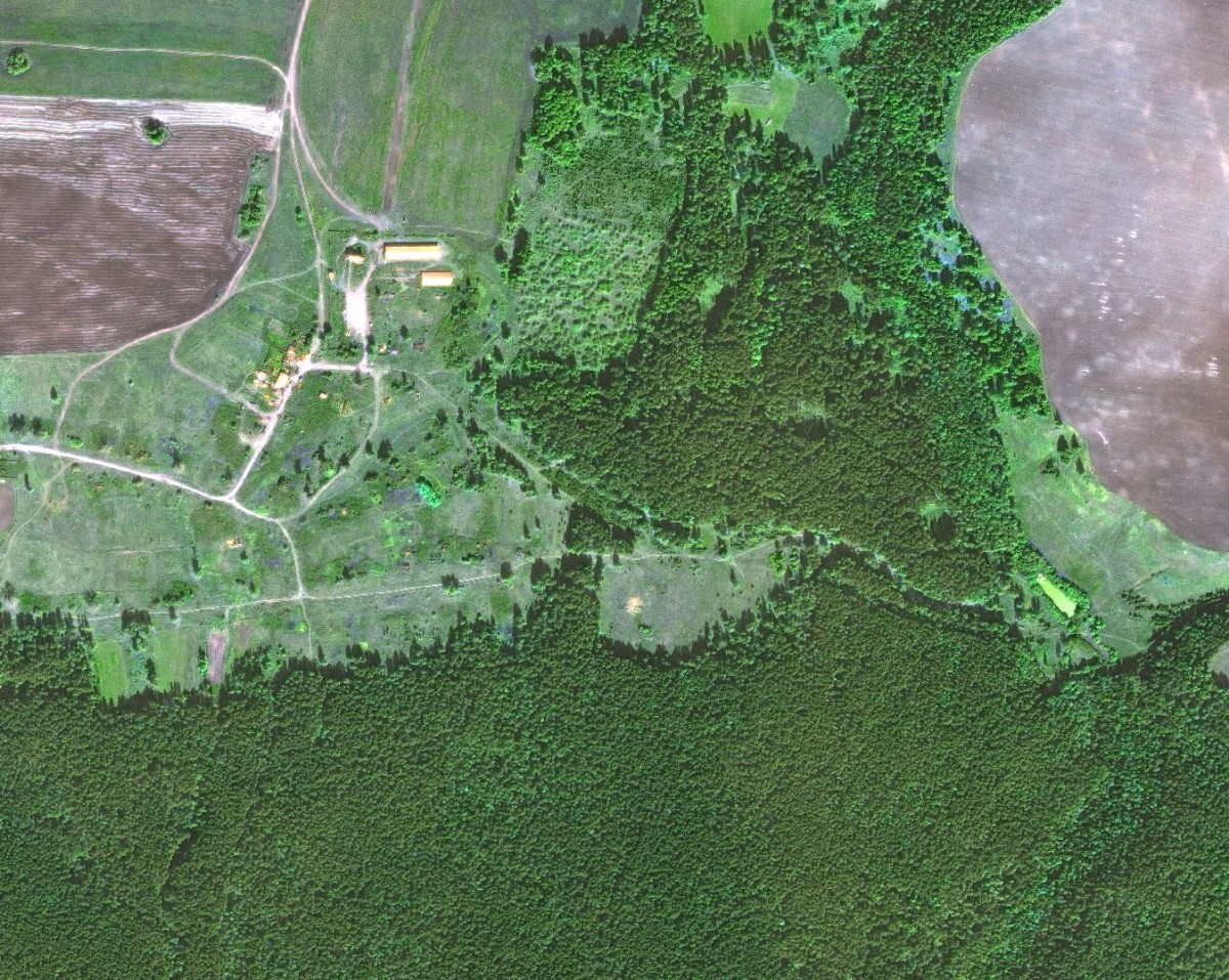
How does a color infrared image differ from natural color?
A natural color image shows the color seen by the human eye under normal conditions. Typically, a CIR image is tuned to display infrared data in red tones. The red wavelength will be displayed as green, and the green wavelength will be displayed as blue. The blue wavelength is not displayed. This is why healthy green vegetation appears bright red, and a CIR image is known as "false-color."
How can a user switch from natural color to CIR on a display?
The user must have software that recognizes all four bands. Such software typically has an interface where band assignments can be changed. If the image is created with the red band (wavelength) as band 1, green as band 2, and blue as band 3, and near-infrared as band 4, natural color on the computer screen will be set with the red channel as band 1 (red), the green channel as band 2 (green), and the blue channel as band 3 (blue). CIR will be set with the red channel as band 4 (NIR), the green channel as band 1 (red), and the blue channel as band 2 (green). Band 3 (blue) is omitted.
Why was color infrared imaging developed?
CIR film was developed during World War II by Eastman Kodak to identify camouflage because it could distinguish vegetation from other materials. Since then, it has been used for many other applications, including vegetation monitoring; the main goal was to track crop or forest viability. A trained analyst can sometimes differentiate between different plant species by their color tone in an image, known as "spectral signature."
What are the advantages of CIR?
Color infrared imaging is particularly effective because the internal cellular structure of healthy plants reflects near-infrared spectrum wavelengths. Chlorophyll in plants reflects green wavelengths; hence healthy plants appear green to the human eye. Additionally, reflected infrared is more reliable for tracking plant viability than reflected green wavelengths. CIR has a tendency to penetrate through hazy atmospheres better than natural colors; it also provides a clearer image. This makes CIR especially valuable in regions with hot and high humidity during the summer.
How are four-channel images used in agriculture?
Four-channel imaging is applicable to agriculture because bright red color is an indicator of robust vegetation. Variations in red color can indicate suppressed vegetation. These disturbances may indicate lack of bioproductivity, insect infestation, nutrient deficiency in the soil, or overwatering. CIR can be used for purposes such as crop inventory and analysis, determination of crop suppression, tracking fertilizer application, and yield assessment. CIR can also help in determining soil properties such as water permeability, salinity, and erosion. The Normalized Difference Vegetation Index (NDVI), derived from digital CIR data, is a key indicator in vegetation analysis.
What is NDVI?
The NDVI index is one of several mentioned in the literature on plant viability. The U.S. Forest Service uses it to assess risks of accidental forest fires. This index is "derived from a normalization mathematical method that uses only the energy measurement of red and near-infrared ranges… NDVI measurement takes into account the sum of red energy absorbed by chlorophyll and the sum of near-infrared range energy reflected by the leaf cell structure (since red and near-infrared measurements are normalized indirectly in the vegetation analysis)". Formula: (NIR – Red)/ (NIR + Red), where NIR is the channel for near-infrared spectral range and Red is the red channel signal.
How is four-channel imaging used in sustainable agriculture?
Sustainable agriculture utilizes technological advances such as GIS, GPS, and Remote Sensing to facilitate agricultural activities. Four-channel imaging provides the farmer with two views of fields – CIR and Natural Color. CIR can provide a clearer picture of vegetation viability and also provide data for calculating NDVI. Ground-level sensors available to the farmer can be mounted on a moving platform or carried manually and remotely scan and/or map the field as it moves. They can output raw images or calculated values based on the data received. The output data can be used with four-channel images to provide greater temporal resolution for indicators such as NDVI.
What benefits does four-channel imaging provide for agricultural programs?
CIR provides different image details, which have natural colors as well as boundaries of crops and vegetation more pronounced in the image. Different crop viability and soil moisture variations are more pronounced with CIR. Data analysis (non-decomposed data) benefits from CIR as controlled or uncontrolled classification, can identify crops and characteristics not visible to the naked eye. CIR provides the opportunity for a more comprehensive visual interpretation and digital analysis. A continuous version for image with natural colors provides the ability to print color maps for farmers with fields displayed in their natural colors.
Sat-Sun: Non-working days