of geospatial solutions
Sat-Sun: Non-working days
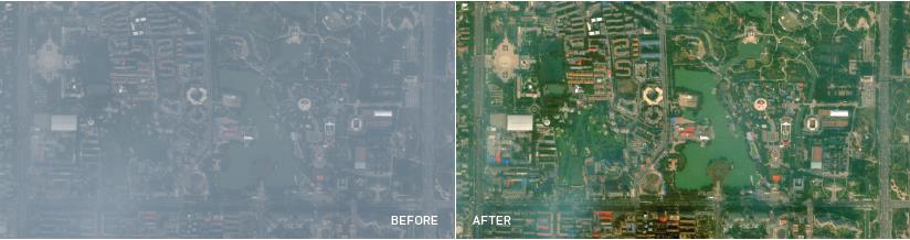
Compensation of Atmospheric Disturbances by DigitalGlobe (AComp) is a proven proprietary algorithm that mitigates the presence of atmospheric haze and atmospheric effects on satellite images. AComp enhances image quality and significantly improves the reliability of information collection and accessibility to the archive.
Advantages
1. Image Clarity
AComp reduces the effects of light wave scattering caused by haze, water vapor, and solid particles in the atmosphere.
2. Acquisition Stability
Atmospheric conditions can diminish image utility, sometimes rendering them unusable. AComp significantly increases the number of usable images obtained during new information collection.
3. Archive Suitability
By applying the AComp algorithm to DigitalGolbe's vast image library, previously marginal or even unusable images become suitable for interpretation and analysis.
4. Enhanced Penetration Capability
By retaining only Earth surface reflectance values, the AComp algorithm enables precise analysis and rapid information extraction. For instance, pixel normalization allows for higher definition of changes, distinguishing spatial and temporal changes in spectral zone images.
5. Automation
DigitalGlobe's AComp algorithm is a fully automated process that performs image processing holistically without manual manipulations, offering higher quality and accuracy than earlier atmospheric disturbance compensation algorithms allowed.
Product Variants
1. Unsupported Product Variants:
a. System-ready (Basic) products - Level 1B
b. WV01 and PAN-only product
c. Images with low SunEL <15 degrees
2. Supported Product Variants:
a. All Ready-to-Process (Standard) products
i. Level 2A
ii. OR2A Level
b. All Ready-for-Mapping (Ortho) products at various scales:
1: 4 800
1: 5 000
1: 10 000
1: 12 000
1: 50 000
Scale on demand.
3. Panchromatic images with multispectral channels (Pan +MS1 set) from all other DigitalGlobe sensors except WorldView-1. The AComp algorithm will also be applied to panchromatic images.
4. Recommended Order Parameters for Quality Maximization.
The parameters listed below indicate the best-case scenario for creating high-quality products. However, you can apply Acomp to images with a solar elevation angle of 15 degrees or higher and still obtain excellent images.
a. 30-degree Sun Angle (Optimal but not required for high-quality products)
Areas with significant elevation changes benefit from a higher sun angle to compensate for topographic irregularities.
b. 16-bit products provide the highest quality.
c. Recommended Basic Components (Non-listed basic components introduce noise)
i. Cubic Convolution (Suggested for Bundle Products)
ii. Bilinear 2x2 (Suggested for SWIR)
iii. Nearest Neighbor (Preferred for scientific tasks)
iv. MTF (Suggested for Bundle Products)
v. Enhanced (pan-sharpened products - default)
vi. Pan-sharpened products (alternate default)
Considerations When Applying AComp
1. In rare cases, the AComp algorithm removes cloud edges. This mode may, in some cases, lead to unnatural discoloration of clouds.
2. Compression artifacts (e.g., banding) may become more pronounced with the AComp algorithm (though, in other cases, less noticeable). A product containing unacceptable bands will be unusable regardless of whether AComp was applied.
3. Shadowed areas tend to appear darker in AComp products, but image details can still be viewed through the shadow.
Conditions Affecting AComp
The conditions listed below may impact the quality of the final AComp product. These conditions do not guarantee poor product quality but indicate situations that may result in products of lower quality:
1. Very sparse vegetation
2. Low solar elevation and solar elevation variations at poles (which can vary within the image)
3. Areas extensively covered by snow and ice
4. Coastal areas with more water than land
5. Open ocean
6. Extensive cloud cover
Product Metadata Change/Update
1. Metadata Changes
2. "ACOMP" must be present in the "radiometricEnhancement" field of metadata
AComp products contain haze magnitude, which RR will include in the ISDF.IMD file and DGProduct store requirements.
3. Metadata will present haze magnitude values (the algorithm calculates the percentage of haze-free pixels on the image. The provided percentage is used for methodical recommendations and does not represent an exact aerosol optical thickness or water vapor measurement)
Example: Haze Magnitude
a. 10 05 25 40 20
4. The left-to-right haze magnitude values indicate the percentage of haze clarity, providing % of haze-free pixels in each category. Five individual digit values represent percentages totaling 100%.
Example: Five digits from left to right
Clear, Moderate Haze, Haze, Strong Haze, & Extreme Haze
5. The haze mask will be created in raster format and stored in the archive, but cannot be ordered or provided to clients.
1. AComp is not a tool for haze removal. AComp reduces the effects of haze and other atmospheric scattering.
2. Issues of striping (banding) in some cases can be significant, though sometimes reduced with the AComp algorithm. There have been cases where no difference was seen comparing images processed with AComp versus those not using the algorithm.
It's important to note that the AComp algorithm is not intended as a tool for stripe removal.
Sat-Sun: Non-working days