Sat-Sun: Non-working days
Abstract:
This article explores the situation in the Chinese market for Earth observation data receiving stations (RSD). It provides a list of the main RSD data receiving stations of interest to the Chinese side, reviews the market landscape (key players, manufacturers, regulators), and outlines the trends.
Introduction
Ground Receiving Stations for Earth Observation Data (EO Data) are specialized terrestrial devices that receive information and images of the Earth's surface using satellites and other space-based platforms. They play a crucial role in collecting and processing data necessary for monitoring and studying various aspects of our planet.
The primary functions of ground receiving stations for EO data include:
- Receiving signals from satellites: Ground stations receive radio signals transmitted by satellites and decode them to obtain information about objects on the Earth's surface.
- Data processing: The received data is processed to create maps, high-resolution images, and other products that can be used for analysis and decision-making in geography, climate, agriculture, and other fields.
- Data transmission: The stations transmit processed data to specialized centers for further analysis and distribution, ensuring access to information for scientific and applied purposes.
- Monitoring changes: Through the data obtained from ground receiving stations, it is possible to track and analyze changes occurring on the Earth's surface, which is important for understanding and addressing various environmental and climate change-related issues.
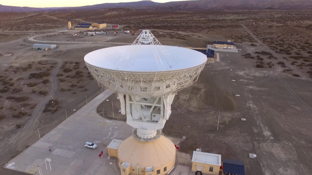
Chinese state and commercial EO data ground receiving stations are designed and data transmission (imagery) capabilities are borrowed from European companies, primarily Kongsberg Satellite Services (KSAT) and Swedish Space Corporation (SSC), with the consent of the European Space Agency (ESA) and based on agreements from 2005-2022. European specialists trained Chinese space telemetry and data transmission technicians, and engineers installed ground stations (GS) and EO data exchange networks between GS. A plant was built in China for the production of GS (antennas of various diameters from 1 meter to 15 meters, servo mechanisms, and electric drives) and equipment for receiving modern EO data from space platforms. Some Chinese commercial EO data companies began independently producing small GS (antennas 1-3 meters in diameter) and offering them to users of their EO data satellite resources. Chinese state companies have created an international network for receiving EO data from Chinese satellites with GS located in foreign countries (a list of GS is at the end of this article).
Since 2022, Chinese commercial companies in the EO data space have been offering a comprehensive package on the global market – the purchase of GS for receiving EO data, GS for satellite control, existing EO satellites in orbit, or the creation of custom EO satellites with launch services to target orbits, software, specialist training, and more.
LTD "GEO Innoter" is a partner of several Chinese companies in promoting such comprehensive packages and provides consulting services to potential customers.
Overview of Chinese EO Satellites
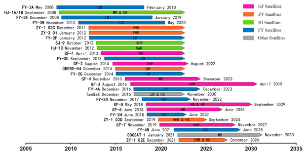
The historical development of China's EO satellite constellation as of 31.12.2023:
Satellite Series:
FY - FengYun meteorological satellites;
GF - GaoFen satellites;
ZY - ZiYuan satellites;
HJ - HuanJing satellites;
SJ - ShiJian satellites;
SDGSAT - Sustainable Development Science Satellite-1 for Sustainable Development Goals;
TanSat - satellite for global CO2 observation and monitoring.
Types of EO Satellites:
VHR (very high resolution) - <10 m (very high resolution);
HR (high resolution) - 10-30 m (high resolution);
MR (medium resolution) - 30-100 m (medium resolution);
LR (low resolution) - ≥100 m (low resolution);
SAR (synthetic aperture radar);
HS (hyperspectral).
Since 2019, the intensity of EO satellite launches in China has surpassed the best years of the USSR and the USA combined.
Chinese Ground Stations (RSGS) and Their Characteristics
The development of data reception technologies (EO) has become crucial in the context of China's space industry. The integration and improvement of data reception stations have become an integral part of the country's strategy to enhance its capabilities in processing and utilizing data acquired from satellites and other space-based assets.
These reception systems are designed with a focus on automation, enabling real-time monitoring and management of data. They support automated operations, calibration, signal acquisition and tracking, and fault diagnostics. As a result, the level of automation in these systems has significantly increased, allowing for more efficient processing of received data.
Despite the significant advantages of using traditional frequency bands such as X-band, modern advancements have enabled China to actively explore and utilize advanced data reception methods in the Ka-band. This advancement significantly expands the capabilities for transmitting EO images without compression, providing a wider bandwidth and higher data transmission speed.
One of the key developments in reception station technology is the creation and utilization of virtual reception devices. This not only enhances data accessibility but also guarantees daily data usage. Satellite data reception and transmission technologies are being actively integrated into modern industrial solutions, including agriculture, forestry, urban planning, and defense.
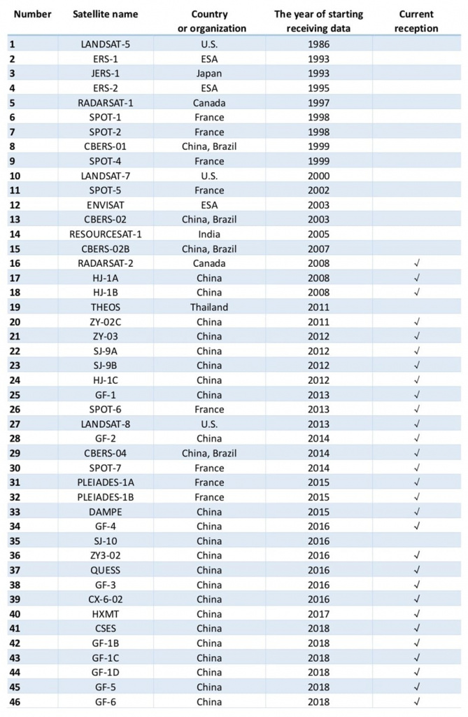
The China Remote Sensing Satellite Ground Station (RSGS), established and operational since 1986, is a major national scientific and technical infrastructure. It is also a member of the international group of Earth observation ground stations. As one of the busiest ground stations globally, RSGS has received, processed, and archived data from over 60+ satellites and more than 7+ million satellite scene images since 1986.
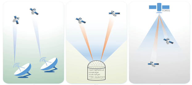
Chinese EO satellites operate in two modes: (1) antennas can operate independently and can simultaneously transmit different images to one or different ground stations; (2) only one antenna can transmit images at a time.
Data transmission methods for EO satellites can be categorized into three approaches:
- Real-time transmission of satellite images (data) to ground stations when the observation object (area of interest) and the ground station are simultaneously in the satellite's visibility zone;
- Initial storage of satellite images (data) in the satellite's onboard memory followed by data dumping to ground stations within the coverage area;
- Through a satellite relay on geostationary orbit (NASA relay station).
As of 2019, more than 110+ companies in China were active in the space segment of the economy, with 12 companies engaged in the creation of EO ground stations (groundstation).
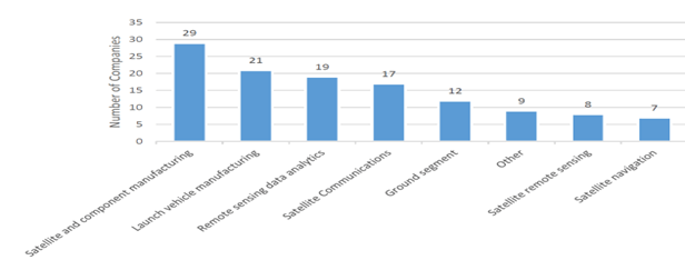
China operates a robust national Earth observation satellite program, including 47 main satellite series:
- Huanjing ("Environment"),
- Haiyang ("Ocean"),
- Gaofen ("High Resolution"),
- Yaogan ("Remote Sensing").
Within the Yaogan series, over 80 EO satellites were launched from 2006 to March 2023. Most of the data from these satellites are not available to the public or for commercial ordering. All data from these government programs are controlled by departments and institutes within the Chinese government.
The main technical capabilities of ground stations include:
- The data reception system can receive satellite data via downlink in S, X, and Ka bands. The main technical parameter is the data reception rate of up to 2 * 600 Mbps (X-band) and 4*1.5 Gbps (Ka-band), which is a world-leading capability. The system is also capable of tracking and quickly capturing high-dynamic satellite signals with low noise levels.
- The data recording system can record, transmit, and quickly display data in real-time with a data recording speed of up to 6000 Mbps.
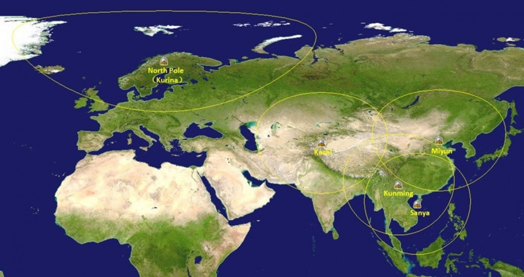
- The data transmission system consists of five high-speed data transmission channels between ground stations Miyun, Kashgar, Sanya, Kunming, the North Pole, and headquarters in Beijing with bandwidths of 10,000 Mbps, 622 Mbps, 622 Mbps, 200 Mbps, and 450 Mbps respectively to ensure high-speed data transmission.
- RSGS has multiple sets of foreign satellite data processing systems, whose information products meet international quality standards and specifications.............
- RSGS also provides various satellite data transmission services, such as online queries of archival data, processing orders for products, loading and delivery of information products, etc. It manages over 3.6 million pages of historical archive data catalog and online archive data of standard products totaling more than 230 TB.
- RSGS can create a virtual ground station (SatSee system) for users, especially from neighboring countries. VGS can provide users with quicklook full-resolution images close to real-time from satellite EO data acquired by RSGS.
- The operations management system manages over 30 Chinese and international Earth observation satellites in polar orbits, geostationary Earth observation satellites, and space science satellites by monitoring, planning, and managing their data reception, recording, transmission systems, mission status, and execution.
Commercial Space Companies in China and Their Technical Characteristics
A significant number of innovative enterprises specializing in research and development of commercial satellites and their utilization have emerged in China, such as Chang Guang Satellite Technology Co., Ltd. (CGSTL), Zhuhai Obita Aerospace Technology Co., Ltd. (Obita), Beijing Space View Technology Co., Ltd. (BSVT), and 21st Century Aerospace Technology Co., Ltd. (21AT), among others. This approach promotes the development of commercial satellite constellations, primarily with ultra-high spatial resolution, in demand in the international Earth observation market. Currently, China's commercial remote sensing satellite constellations funded by non-governmental financing mainly include TripleSat, Jilin, Zhuhai, SuperView, and others. Jilin-1 is China's first truly independent series of commercial Earth remote sensing satellites, with a resolution of 30 cm/pixel. All these companies have ambitious plans to expand their satellite constellations.
The main commercial companies from China entering the international Earth observation market are presented in the table below.
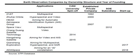
During the initial phase of development, many Chinese commercial satellite companies engaged in all satellite sectors, including satellite manufacturing, operation, ground station development for reception and control, software creation, and services using Earth observation data. Due to the absence of space infrastructure for commercial use, these early commercial satellite companies could not outsource any of their activities. As China's commercial space industry developed, existing satellite companies realized they lacked the capital to build their own ground stations, as the cost of constructing ground stations required significant investments compared to the projected revenues from satellite image sales. This created demand for outsourcing ground station and TT&C (Telemetry, Tracking and Command) services, leading to the growth of specialized startups aiming to fill this market gap.
According to Chinese space experts, as of 2022, about 12 companies are engaged in TT&C services, primarily positioning themselves as TT&C solution providers.
Other companies in this segment offer their own ground station services as a secondary business. For example, 21AT owns and operates ground stations in Beijing and serves several foreign satellites, but ground station services are not its primary business.
These TT&C service providers have business models similar to Kongsberg Satellite Services (KSAT) and Swedish Space Corporation (SSC). Until 2021-22, these two companies collaborated with other Chinese companies to gain access to ground stations in other parts of the world.
As of January 2024, Chinese companies view KSAT and SSC as competitors rather than potential partners, largely due to increasing political tensions between the NATO bloc and China. Most new Chinese companies have either built or plan to build their own ground stations. Some Chinese satellite manufacturers also produce ground station equipment that they can sell to these commercial TT&C service providers.
The heart of the Chinese TT&C industry is located in Xi'an, where the largest facility of the China National Space Administration's Launch and Tracking Control (CLTC) serves as the main national TT&C center for space missions. When satellites or other objects are launched or need to receive data, they often pass through CLTC in Xi'an.
Noteworthy are Satellite Herd (航天驭星) and Tianlian TT&C (天链测). Satellite Herd has captured 80% of the domestic commercial market, servicing 24 commercial satellites. It operates its own ground station factory.
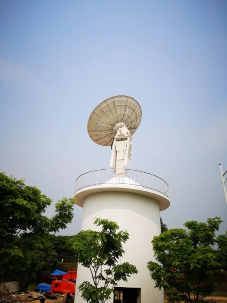

As of early 2022, these TT&C commercial companies had very few clients because most of them did not have the infrastructure to serve satellite companies. Their current clients mainly consist of new commercial satellite companies and universities. The client base for the TT&C industry is expected to grow as commercial satellite companies expand and more satellites are launched into orbit. For commercial satellite companies planning mega-constellations and global coverage, access to foreign users can be provided. However, the health of the TT&C commercial industry will depend on the growth of the commercial satellite industry in China. As a result, these new TT&C companies are also targeting foreign clients to expand their client base.
By planning to build ground stations worldwide, these TT&C commercial companies not only provide Chinese clients access to overseas communication markets but also enable foreign clients access to the Chinese satellite communication market. Since most foreign TT&C service providers do not have this capability, the Chinese government will not easily allow foreign companies to build their own ground stations in China. Commercial companies with access to ground stations in China exclusively serve Chinese users.
China's commercial space industry has become a focal point of global attention and a key word in the development of China's aerospace industry in recent years. Due to the low technical threshold and simplicity of network interaction, Earth observation satellites have become the fastest-growing category of satellites in China's commercial aerospace industry, directly leading to the X-band, a traditional data transmission range for Earth observation satellites. However, the traditional data transmission range for Earth observation satellites is quickly saturating in a geometric progression. This situation compels data transmission on ground stations to shift to the Ka-band with higher frequency and wider bandwidth. Chinese commercial ground station companies are prepared to offer technical solutions and investments.
State Grid of China's Earth Observation Network
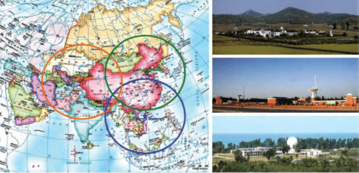
The Chinese state network of ground stations for satellite remote sensing was established in 1986. Currently, it comprises three main receiving stations in northern, western, and southern China capable of receiving data from 20 international and over 40 domestic Earth observation (EO) satellites, covering the entire territory of China and 70% of Asia.
Additionally, Chinese ground stations with diameters less than 5 meters are distributed throughout mainland China, and the near real-time data transmission capability is particularly crucial for the country.
A topological data transmission model has been constructed to reduce data transmission time, considering the characteristics of responsive satellites. Based on this model, three conceptual areas have been adopted in China:
- To quickly deliver observation results, the shortest path among alternative data transmission paths should be selected for each target.
- Satellites represent limited resources that must be utilized most efficiently to satisfy a large number of consumer requests.
- All satellite resource constraints must be adhered to in order to reduce platform risk.
RSGS operates under the guidance of the Center for Earth Observation and Digital Earth (CEODE) of the Chinese Academy of Sciences (CAS), capable of receiving data from international and domestic satellites. The center can provide a full range of high and low-resolution imagery products as well as optical and radar imaging products, essentially realizing the goal of creating an all-weather, 24-hour, multi-resolution, space-based Earth observation (EO) information center in China.
Currently, this is the combined Chinese Center for Satellite Data and Application Resources (CRESDA) within the National Satellite Meteorological Center (NSMC), Earth Observation (EO) Center, and National Ocean Satellite Application Service (NSOAS).
China has built a networked operational system for receiving remote sensing satellite data based on modern cloud and IT technologies.
The network interaction algorithm of the ground stations is shown in the figure below.
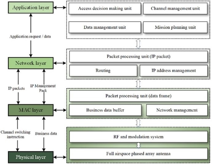
Thus, the data reception system stations are distributed among three receiving stations. Its main equipment includes antennas, tracking and management systems, demodulators, and recording systems.
The Miyun Station has four medium and large antennas, with antenna diameters of 10, 11, 6, and 12 meters (in order of their construction).
Both Kashgar and Sanya Stations have two 12-meter antennas. The operating range of these antennas is the X-band, and their reception capabilities differ due to different apertures. The gain coefficient of these 12-meter antennas is 35 dB, and they have the capability of polarization multiplexing in the X-band. Currently, all stations have the capability to receive data at speeds up to 800 Mbps via dual downlink communication lines.
Characteristics of some key parameters of the 12-meter antennas:
- Reflector antenna size: 12 meters.
- Radio frequency (RF) range: 89 GHz.
- X-band G/T at 58: 35 dB/K.
- Storing multiple satellite passes and satellite planning.
- Highly efficient reflector specifically designed for remote sensing.
- Automatic tracking capability in the S/X Omni semisphere.
- Motorized, inclined, railway pedestal eliminates "keyhole effect".
- Real-time moving window display.
- Real-time data transmission to the data processing center.
- Two-polarization channel with high polarization isolation.
- High-speed data demodulators and bit synchronizers, data transmission rate up to 2*450 Mbps.
New ground stations (launched in 2022) and planned.
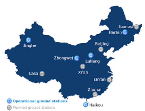
There is a centralized monitoring and management architecture.
The CEODE headquarters are located in Beijing. Currently, the bandwidth between the Miyun station and CEODE is 1 Gbps, and from Kashgar and Sanya stations is 155 Mbps.
The data transmission channel capacity will be expanded to 10 Gbps, 622 Mbps, and 622 Mbps, respectively.
The data reception management and monitoring system is responsible for processing satellite management system tasks and unified ground data reception resource planning. Its main functions include receiving generated tasks, data reception system operation planning, and data quality control. It also monitors the operational status of the data reception system and real-time business flows, updates and summarizes information on the equipment status in the data reception system, and provides task execution reports.
As China's Earth observation satellite series over the next 10 years is expected to increase to 400 spacecraft, launched step by step, including satellites for resource exploration, environmental observation, and mapping, the ground stations for satellite remote sensing will receive and process even more data from a larger number of satellites. To address this, some enhancements to the ground station network are required. The data reception system's downlink transmission rate capability should reach 2.5 Gbps.
For example, the data collection rate of COSMO-SkyMed satellites (second generation) can already reach 2x1.2 Gbps, while the data transmission rate and onboard storage capacity are only 2x260 Mbps and 1500 Gbps respectively.
Therefore, image compression is on the agenda. With the development of onboard image compression algorithms and hardware design, the image compression module has become an indispensable payload of Chinese Earth observation satellites in 2023. For instance, the image compression module can provide seven different compression ratios: 10:10 (no compression), 10:6, 10:5, 10:4, 10:3, 10:2, and 10:1. There are two classes of image compression methods: lossless compression and lossy compression. Generally, the higher the compression ratio, the more information is lost during compression.
Finally, the impact of data storage resources on information capacity is being studied, and the difference between information capacity and traditional communication capacity. Information and communication capacities range from 30 Gbps to 180 Gbps. As can be seen, communication capacity does not change depending on storage resource capacity because it does not take into account the impact of storage resources. Specifically, when the allowable delay is small, information capacity tends to saturate after a short period of nearly linear growth. This occurs because in this case, only data obtained from observational targets near the ground station have the opportunity to be uploaded, and the required memory volume is very limited. When the allowable delay is large, information capacity has nearly linear growth with communication resource capacity over a longer period and then tends to saturate. This happens because in this case, a large amount of data can be delivered through the storage-transmission paradigm, so a large memory volume is required.
To ensure continuous contact with the satellite throughout its orbit, road-mobile ground station systems and specially equipped ships are often used. China leases or builds ground stations outside its territory to provide coverage. For example, the widely known project with Brazil, CBERS.
![Integrated mobile ground station Technical
<h2>Location of Chinese Deep Space Tracking Stations with Coordinates</h2>
<h3>Stations Within China</h3>
<p><strong>Organization Location Coordinates</strong></p>
<p><strong>China Satellite Launch and Tracking Control General Department (CLTC)</strong></p>
<p>Beijing headquarters 39.962253, 116.385927</p>
<p><strong>China Satellite Maritime Tracking and Control Department (Base 23)</strong></p>
<p>Jiangyin, Wuxi, Jiangsu Province 31.942827, 120.288723</p>
<p><strong>Unconfirmed Affiliation SSF Early Warning / Space Tracking Large Phased-Array Radars</strong></p>
<p>LPAR, Yiyuan County [沂源县], Shandong Province 36.024856, 118.092048</p>
<p>LPAR, Lin'an District [临安区], Zhejiang Province 30.286567, 119.128608</p>
<p><strong>Beijing Aerospace Flight Control Center</strong></p>
<p>Headquarters 40.071983, 116.256847</p>
<p><strong>Xi'an Satellite Control Center (XSCC) (Base 26)</strong></p>
<p>Changchun Station [长春站], Changchun, Jilin Province 43.725332, 125.540836</p>
<p>Qingdao Station [青岛测控站], Qingdao, Shandong Province 36.194830, 120.302880</p>
<p>Nanning Station [南宁测控站], Nanning, Guangxi Province 22.888060, 108.304440</p>
<p>Menghai Station [勐海测控站], Menghai County, Yunnan Province 21.946553, 100.452665*</p>
<p>Yao'an Substation [63760部队姚安分站], Yao'an, Yunnan Province 25.489181, 101.169445*</p>
<p>Lingshui [陵水测控站], Lingshui, Hainan Province 18.439798, 109.874072</p>
<p>Jiamusi Station (LPAR Sub-Station), Huanan County, Heilongjiang 46.528092, 130.755276</p>
<p>Weinan Tracking Station [渭南测控站], Dongyuan, Shaanxi Province 34.467904, 109.544941</p>
<p>Zhanyi Station [沾益(测控)站], Zhanyi County, Yunnan Province 25.638159, 103.715123</p>
<p>Mobile Tracking & Recovery Department [活动测控回收部], Weinan, Shaanxi Province 34.503420, 109.416442 *</p>
<p>1st Mobile Station, Weinan, Shaanxi Province 34.482661, 109.487657</p>
<p>2nd Mobile Station, Hetian, Xinjiang AR 37.164167, 79.871307 *</p>
<p>3rd Mobile Station (main base) 42.039565, 111.534044</p>
<p><strong>Deep Space Network (under Xi'an SCC)</strong></p>
<p>Jiamusi, Heilongjiang Province 46.493403, 130.770409</p>
<p>Kashgar, Xinjiang AR 38.423420, 76.712207</p>
<p>Neuquén, Argentina -38.191439, -70.149627</p>
<p><strong>Jiuquan Satellite Launch Center (JSLC) (Base 20)</strong></p>
<p>Jiuquan Satellite Launch Center [酒泉卫星发射中心], Alxa, Inner Mongolia AR 40.983507, 100.206390</p>
<p>Secondary landing site [副着陆场] 40.536242, 101.022394 *</p>
<p>Dashuli Radar Tracking Station [大树里雷达测量站] 40.722291, 99.992276</p>
<p>U/I optical tracking station [光学测量站点] 41.326159, 100.365313*</p>
<p>U/I telemetry station 41.103952, 100.279730*</p>
<p>Large Phased Array Radar (LPAR) Korla, Xinjiang AR 41.641194, 86.236749</p>
<p><strong>Taiyuan Satellite Launch Center (TSLC) (Base 25)</strong></p>
<p>Taiyuan Satellite Launch Center [太原卫星发射中心], Kelan County, Shanxi Province 38.848333, 111.610278</p>
<p>Telemetry station 38.808858, 111.611199</p>
<p>China's Ground Segment</p>
<p>80</p>
<p>Dongfang Aerospace Port [东方航天港], Haiyang, Shandong Province 36.672862, 121.235374</p>
<p>Unit 63726 (possible) LPAR station [XL-3208雷达站], Kongtong Dist., Gansu Province 35.483025, 106.571871</p>
<p>Main radar tracking station [阳曲站], Yangqu, Shanxi Province 38.016892, 112.636536</p>
<p>Mobile radar station, 6th dui, Yinchuan, Ningxia AR [宁夏银川] 38.494519, 106.277348 *</p>
<p>Xingxian Station [兴县站] 38.507539, 110.920224 *</p>
<p><strong>Xichang Satellite Launch Center (XSLC) (Base 27)</strong></p>
<p>Xichang Satellite Launch Center [西昌卫星发射中心] Liangshan Yi Autonomous Prefecture,</p>
<p>Sichuan Province</p>
<p>28.245963, 102.028178</p>
<p>Niutoushan tracking station [牛头山观测站/牛头山测控点] 28.196568, 102.069191</p>
<p>Tracking station 27.911767, 102.209881*</p>
<p>Yibin Satellite Observation and Measurement Station [宜宾测量站], Yibin, Sichuan 28.743607, 104.611790</p>
<p>Yibin Barracks 28.764813, 104.641389</p>
<p>Baita Mountain, Yibin possible auxiliary station 28.775649, 104.634663 *</p>
<p>Guiyang Observation Station [贵阳观测站] in Huaxi County, Guizhou 26.409398, 106.670273</p>
<p><strong>Wenchang Spacecraft Launch Site (WSLC) (Under Xichang SLC)</strong></p>
<p>Wenchang Spacecraft Launch Site [文昌航天发射场], Wenchang, Hainan Province 19.652510, 110.938741</p>
<p>Tongguling tracking station [铜鼓岭测控点] 19.639694, 111.029314</p>
<p>Paracel Islands tracking station [西沙测控站], Duncan Island</p>
<p>[三沙市西沙群岛琛航岛]</p>
<p>16.451586, 111.713916</p>
<p><strong>Unidentified / Possible Space Tracking or Missile Instrumentation Sites</strong></p>
<p>Possible (PLAAF) LPAR Hui'an, Fujian Province [福建省泉州市惠安县] 25.126471, 118.751507</p>
<p><strong>Aerospace Information Research Institute (AIR)</strong></p>
<p>Kashgar Station 39.504344, 75.930372</p>
<p>Miyun Station 40.451465, 116.858186</p>
<p><strong>CAS National Astronomical Observatories of China [</strong>国家天文台<strong>]</strong></p>
<p>Beijing Observatory Station, Miyun, Beijing 40.557929, 116.976632</p>
<p>Changchun Satellite Observatory [长春人造卫星观测站] 43.790677, 125.443823</p>
<p>Possible Substation 43.793982, 125.458251</p>
<p>Sheshan Observatory Station [余山站], Shanghai (under Shanghai Observatory) 31.099321, 121.199758</p>
<p>Xinjiang Observatory Nanshan [南山] 43.471881, 87.177425</p>
<p>Yunnan Astronomical Observatory [昆明]
<p><strong>Communications Stations</strong></p>
<p>Beijing Satellite Communications Earth Station [北京卫星通信地球站] 40.050966, 116.274398</p>
<h3>International Stations</h3>
<p>Argentina Neuquén -38.192607, -70.148405</p>
<p>Australia Dongara -29.046755, 115.351077</p>
<p>New Norcia -31.0482, 116.191</p>
<p>Brazil Alcântara Launch Center -2.334606, -44.419621</p>
<p>Canada Inuvik 68.319464, -133.552426</p>
<p>Chile Santiago Station -33.150239, -70.667962</p>
<p>Ethiopia Addis Ababa, Entoto Observatory 9.108695, 38.807249</p>
<p>France Kourou, French Guiana 5.222222, -52.773611</p>
<p>Issus Aussaguel, Toulouse, France 43.428655, 1.497401</p>
<p>Kerguelen Station -49.351939, 70.256424</p>
<p>Greenland Kangerlussuaq 67.018341, -50.708817 *</p>
<p>Nuuk 64.182770, -51.733997 *</p>
<p>Kiribati Tarawa - <em>No longer active </em>1.356354, 172.932916 *</p>
<p>Kenya Malindi -2.996044, 40.194204</p>
<p>Namibia Swakopmund -22.574645, 14.548539</p>
<p>Norway Arctic Yellow River Station [黄河站], Ny-Ålesund, Svalbard 78.9232, 11.9345</p>
<p>Svalbard Satellite Station 78.230302, 15.395534</p>
<p>Pakistan Karachi, Dehmandro 25.193106, 67.099325</p>
<p>Spain Maspalomas Station 27.7633, -15.6342</p>
<p>South Africa Hartebeesthoek satellite ground receiving station -25.890095, 27.685227</p>
<p>Sweden Kiruna 67.881219, 21.061046</p>
<h3>Chinese Scientific Stations in Antarctica</h3>
<p>Great Wall Station [长城站] -62.216838, -58.961855</p>
<p>Kunlun Station [昆仑站] -80.41734, 77.116449</p>
<p>Taishan Station [泰山站] -73.85, 76.966667</p>
<p>Zhongshan Station [中山站] -69.373587, 76.37165</p>
<p>If needed, GEO Innother LLC has a detailed description of each of China's ZSs.</p>
<h2>Brief Description of Types of Ground Stations in China</h2>
<p><strong>In the Chinese market, mobile ground stations and transport variants are offered.</strong></p>
<figure><img class=' img-fluid ' width=](/upload/medialibrary/b7b/china_dzz_24.png)
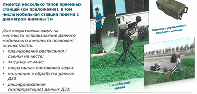
Integrated Mobile Ground Station supports measurement and management of commercial satellites in the X-band and reception of low-speed data transmissions.
Functions:
The power source can be manually replaced, operating in major frequency bands such as L/C, and can be configured for simultaneous operation in dual-frequency mode according to customer requirements; The antenna has high efficiency, low sidelobe levels, good electrical characteristics, and transmission and reception polarization modes can be switched; Antennas with diameters of 1.2m, 1.8m, and 3m. The parabola is made of carbon fiber for high precision and low weight. Other antenna diameters and materials can also be customized. Antennas with diameters less than 1.8 meters are highly portable, and 1-2 people can perform various tasks in a portable manner, while a 3-meter diameter antenna can be moved, with 3-4 people performing mobile maneuvers. Lightweight equipment design, low power consumption, capability to be powered by a portable gasoline engine, battery, etc., capability to be equipped with small satellite communication products or multi-mode aggregation communication products for real-time data transmission; Supports automatic north orientation correction, fast alignment, and other portable mobility capabilities.
Supports power from 48V electric vehicle battery
Implement fast alignment and north search.
Easy to transport, quickly folds and unfolds
Vehicle-mounted Ground Station
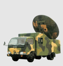
Description:
Functions include satellite telemetry, remote control, speed measurement, distance measurement, tracking, high-speed data transmission, reception, storage, and forwarding of data, and can be expanded for full reception of S-band telemetry.
Functions:
- Uses the "one car - one station" loading method and features such functions as one-button automatic deployment and retrieval, automatic north search, independent positioning, and automatic body alignment.
- Capable of receiving dual-band standard and non-coherent measurement and control signals with an extended S/X spectrum on the downlink.
- Capable of receiving X-band satellite data transmission signals on the downlink.
- Has functions for receiving control commands, command encoding, and modulation and transmitting modulated commands via the uplink channel.
- Has dual-band S/X measurement and control capabilities, as well as data transmission tracking capabilities, and tracking functions such as manual tracking, program tracking, and automatic tracking.
- Has GPS/Beidou signal reception and external IRIG-B (AC/DC) time signal reception capabilities, as well as local time system generation and frequency standardization. With automatic phase correction function.
- Has functions such as orbit prediction, mission planning, switching between multiple satellites, and automatic operation.
- Has real-time and post-processing functions, telemetry data display and printing.
- It has equipment self-checking function with feedback, provides telemetry bit error rate testing statistics, frame loss statistics, and frame error statistics.
Miniaturization, high integration degree, rapid expansion and contraction. Generalized, standardized, and modular construction significantly reduces equipment volume. Automatic folding and unfolding of antenna surface "one button", automatic alignment of large plate and north determination technology significantly enhance the rapid response capability and mobile deployment capability of the system.
Multi-functional integration of measurement and control and remote sensing data reception and processing is integrated, and missile telemetry data reception and processing capabilities can be expanded to meet the requirements of future multi-functional and efficient equipment integration development.
The system design focuses on automatic monitoring and management, automatic operation management, automatic calibration, automatic capture and tracking, automatic fault diagnosis, and other functions to improve the system's automation level.
Virtual Reception of Remote Sensing Data from Chinese Satellites
It is significant that in China, "virtual" reception of remote sensing data (DZZ) between ground stations (ЗС) and satellites (КА) is already in operation and offered.
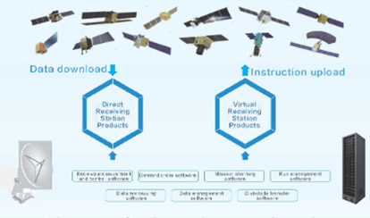
Product forms include virtual reception station products and direct reception station products, with virtual reception station products based on remote sensing products.
Supported by industry cloud base IT Pro, it provides interactive and fast client services for data collection through dedicated optical fiber lines and the Internet.
Direct reception station prod- data upload instructions uct - is a product that provides users with a set of independent fast service products - extended service capabilities - from satellite data reception to processing.
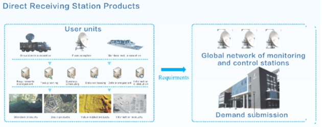
Data is received and processed at China Siwei, and can be transmitted to user devices via dedicated fiber optic lines, dedicated cloud lines, and the Internet. The main tasks of the service are regular monitoring, regular surveys and mapping, response to emergencies, and other data collection needs.
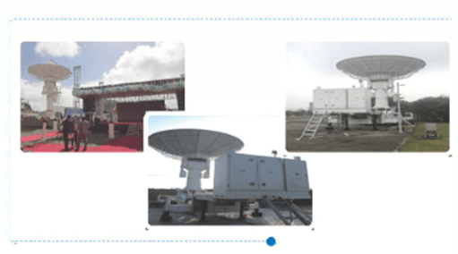
Service scene. Targeting overseas users of Chinese satellite remote sensing (DZZ), users with independent reception capabilities, and users with high demands for timely data transmission services.
By creating products for direct reception stations, it is possible to maximize the timeliness of data transmission service provision.
For users with operational needs for remote sensing image usage, it includes many areas such as agriculture, forestry, water resources protection, land resources, urban construction, ecological environment, disaster prevention, and national defense applications.
Creating virtual reception devices ensures guarantees for daily data access.
Usage of Ka Band for Receiving Remote Sensing Data from Chinese Satellites
The development of Ka-band receiving-transmitting equipment has begun as a satellite remote sensing data transmission band. Test trials for China's ground stations (ЗС) have been conducted. Natural research and test trials have been conducted to select frequency bands.
In terms of Ka-band characteristics, satellite network fillings, reserve compatibility, and compatibility with the IMT single-frequency system, this band is the most suitable and sufficient for transmitting uncompressed EO images.
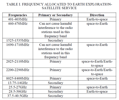
Considering that satellite remote sensing satellite transmission usually requires a wider bandwidth to achieve higher data transmission speeds. While the S-band is mainly used in satellite TT&C tasks, it is challenging to simultaneously perform data transmission applications to the ground. Therefore, the primary frequency band for satellite remote sensing data transmission is the X-band, i.e., the 8025-8400 MHz range.
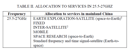
As shown in Table 1, the X-band used in the Earth exploration-satellite service (EO) as seen in the table above, refers to the 8025-8400 MHz frequency band, which is 375 MHz wide. Meanwhile, the Ka-band - Earth exploration-satellite service (Table 2) refers to the 25.5-27 GHz bandwidth, totaling 1500 MHz, which is four times wider than the X-band.
The task set for developers of Chinese satellites and ground stations (ЗС):
1) Promote the development of Ka-band device industry and expedite Ka-band application in practical systems. Although compared to the traditional X-band, the Ka-band has many issues such as high transmission losses, strong rain attenuation, and immature devices, these issues will be gradually addressed with the rapid development of Ka-band in satellite systems. Users of satellite remote sensing systems (especially commercial ones) can begin researching and applying Ka-band data transmission in advance.
2) Declare the provision of satellite Earth exploration services in the Ka-band satellite network at an early stage.
Currently, the number of applications registered in the ITU database for Ka-band satellite networks is not very large. If domestic Chinese satellite operators of remote sensing systems have a need to use the Ka-band for data transmission in the proposed scientific satellite system, they should promptly apply to the ITU for satellite network creation in the Ka-band to ensure access to frequency resources when deploying real systems.
3) The development impact of the IMT system is expected to accelerate under the current state of image transmission issues that need to be fully deployed in satellite remote sensing satellite ground stations.
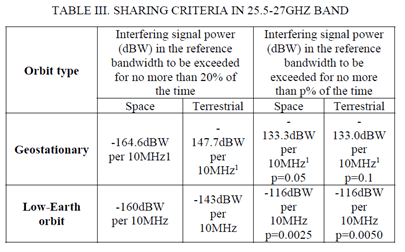
Modeling results show that interference from the IMT system to ground stations falls within the sharing criteria, with the IMT system using the 25.5-27 GHz band. The IMT system uses the 25.5-27 GHz band only as a complement to the "hot spot" area, which is geographically isolated from the ground station service area. However, in the worst-case scenario, the maximum protective distance between IMT base stations and ground stations still reaches up to 7 kilometers. Therefore, when users of satellite remote sensing systems deploy ground stations, they should seek the opinion of the national radio administration to ensure sufficient protection between base stations and ground stations. This is necessary not only to avoid harmful interference from the IMT system but also to ensure the normal operation of ground stations.
Conclusion
- With the help of foreign technologies for creating and receiving remote sensing signal and information, China has progressively developed its ground stations and successfully offers them in the international market.
- China is developing advanced ground stations with information reception speeds from orbit up to 1.5 Gbps.
- The increase in launches of Chinese remote sensing satellites has highlighted the problem of insufficient reception ground stations.
- Chinese commercial companies producing remote sensing information reception ground stations and providers of remote sensing data focus on antenna diameters of 1-5 meters.
- Currently, China severely lacks reception and control ground stations for remote sensing satellites in the polar circle region, giving good negotiating positions to Russian companies.
- As a result of aggressive NATO policies, China has been deprived of using remote sensing reception ground stations in NATO member and ally countries.
LTD "GEO Innoter" as of April 22, 2024, successfully consults Chinese companies and prepares them for entry into the Russian market with remote sensing data reception ground stations. According to the implemented contract, the planned start date for the operation of the remote sensing data reception ground station park from Chinese remote sensing satellites in the Russian Federation is no earlier than 2025Q2.
