How the Earth's poles are studied from space photos
The North and South Poles of all places on our planet have been explored the most recently. This, of course, is easily explainable, because their remoteness and severity of climate do not allow a person without special training to reach them.
The first attempt to explore the North Pole of the Earth was made in the early 17th century by Englishman Henry Hudson. The interest to this region was conditioned by the search of the shortest way from Europe to China. However, at the eastern coast of Greenland the way to the north of the explorer was blocked by ice. The first to reach the North Pole, and their achievement was not questioned, were the members of the Soviet high-latitude air expedition "Sever-2". The expedition was led by Alexander Kuznetsov, head of the Glavsevmorput, and the participants were Pavel Gordienko, Pavel Senko, Mikhail Somov, Mikhail Ostrekin and others. On April 23, 1948, flying on three planes from Kotelny Island, they landed practically on the point 90°00'00" north latitude. Later, the North Pole was explored repeatedly, arriving both by air and by sea.
Official discovery of Antarctica
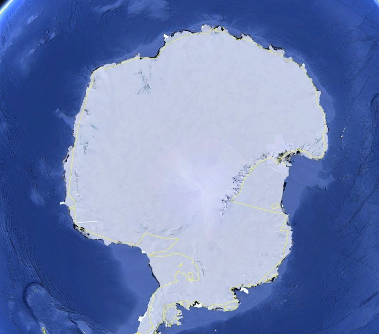
The first people who officially discovered Antarctica and set foot on its "land" were our compatriots Thaddeus Bellingshausen and Mikhail Lazarev. As part of the expedition to the South Pole of the Earth, he and his team first reached the shores of Antarctica. However, the outline of the continent and its geology remained under a veil of mystery for many years after the discovery. After that, many scientists made attempts to reach the south pole of the Earth and each made some contribution to the study of the continent. However, it was the Norwegian Roald Amundsen with 5 satellites on December 14, 1911 after a 2-month grueling trek was able to reach the extreme mark of 9000'00" south latitude. It is noteworthy that almost simultaneously with them tried to reach the South Pole Robert Scott and his team. And they succeeded, but alas, only a month after the completion of the expedition of Rual Amundsen. Subsequently, the study of Antarctica and the South Pole, in particular, were engaged in many expeditions. Now there is a permanent station at the South Pole and even a telescope for astronomical research has been built.Photo of the South Pole from space
When was the first photo of the Pole from space taken?
Nowadays, exploring such distant places from the usual life does not look something difficult anymore. Satellite systems make it possible to regularly receive fresh and reliable information about any point on the planet, including the Earth's poles.
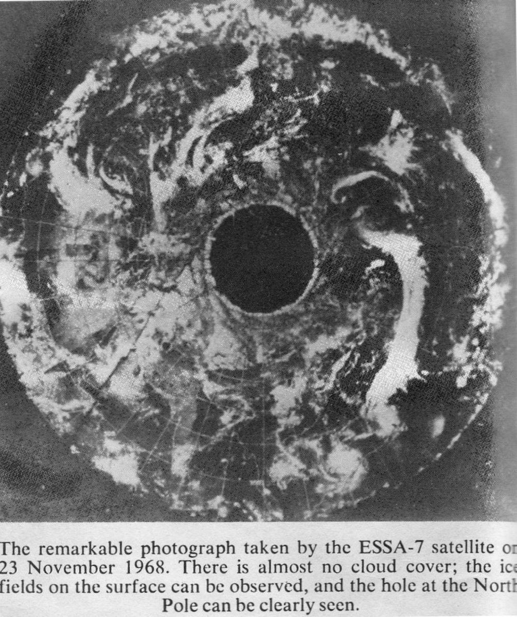
The first photos of the poles from space were obtained in the 1960s from the American meteorological satellites ESSA. Photo of the North Pole from ESSA 7 satellite from 23.11.1968
This image has generated a lot of speculation about a huge hole at the North Pole and the so-called "entrance to the underworld". However, the black spot on the image is nothing but a defect in the image. In those distant times, satellite photography was far from perfect, and it was especially difficult to get the film back to Earth. The film was lowered in a special module, and in the process of transportation the images were spoiled more than once.
High-resolution images of Antarctica from space
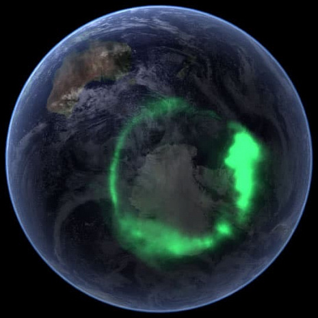
An image of Antarctica with the aurora borealis
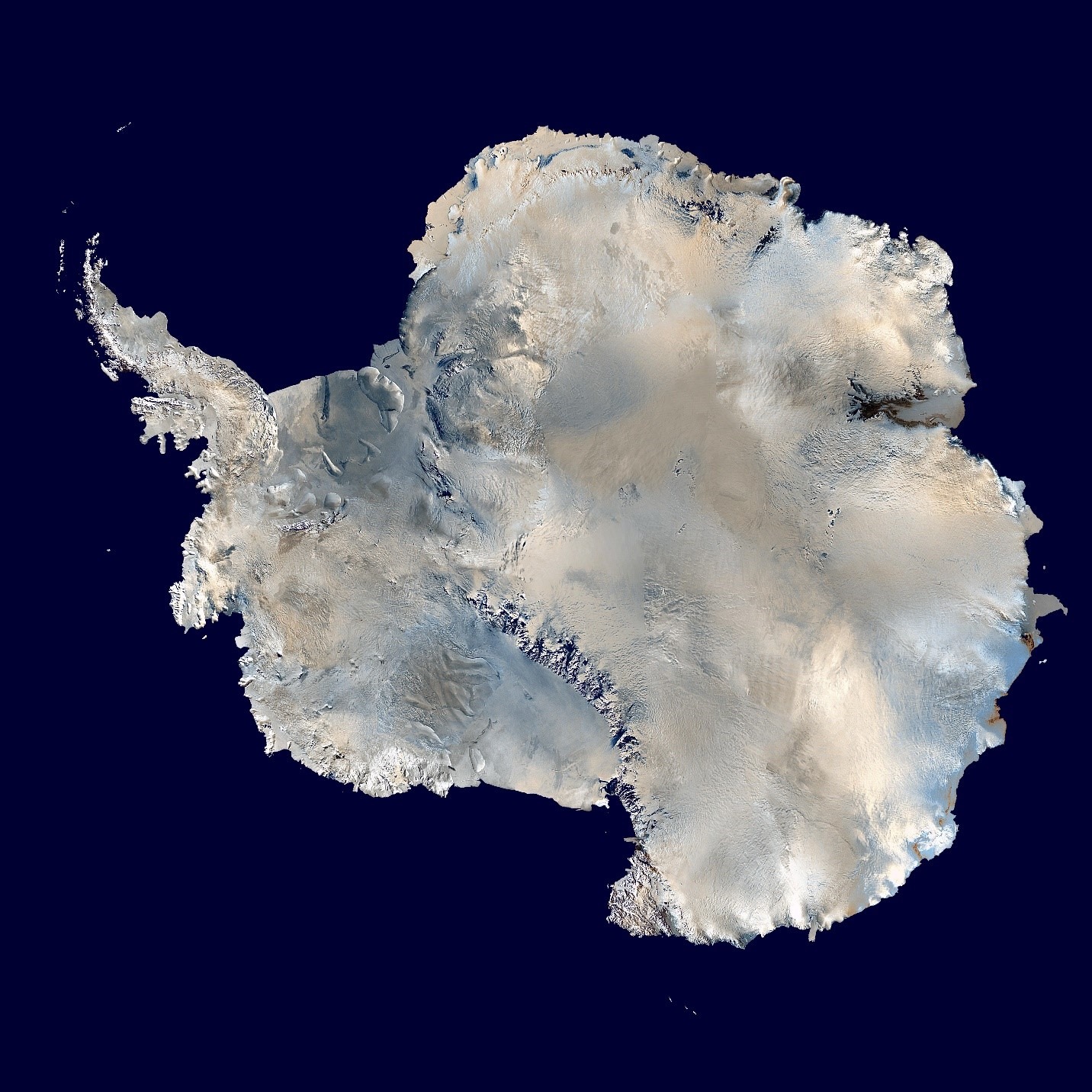
In the era of digital imaging, the only thing that makes it difficult to study the Earth's poles is that the orbit of most operational satellites ends at about the 80th parallel, which means that they cannot physically capture such remote places. But anyway NASA Landsat-7 mission has made a complete detailed survey of Antarctica and the South Pole. From 1999 to 2001, more than 11,000 images were taken from different angles. Further, in 7 years scientists managed to create the most detailed map of Antarctica at that time - its accuracy was ten times higher than all the materials available at that time. This allowed filling the gaps in the study of relief and landscapes. While compiling the map, scientists discovered extremely interesting facts: the images clearly showed the craters of extinct volcanoes, which means that Antarctica was not always bounded by ice.The resulting mosaic of Antarctica
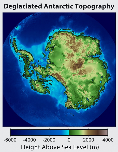
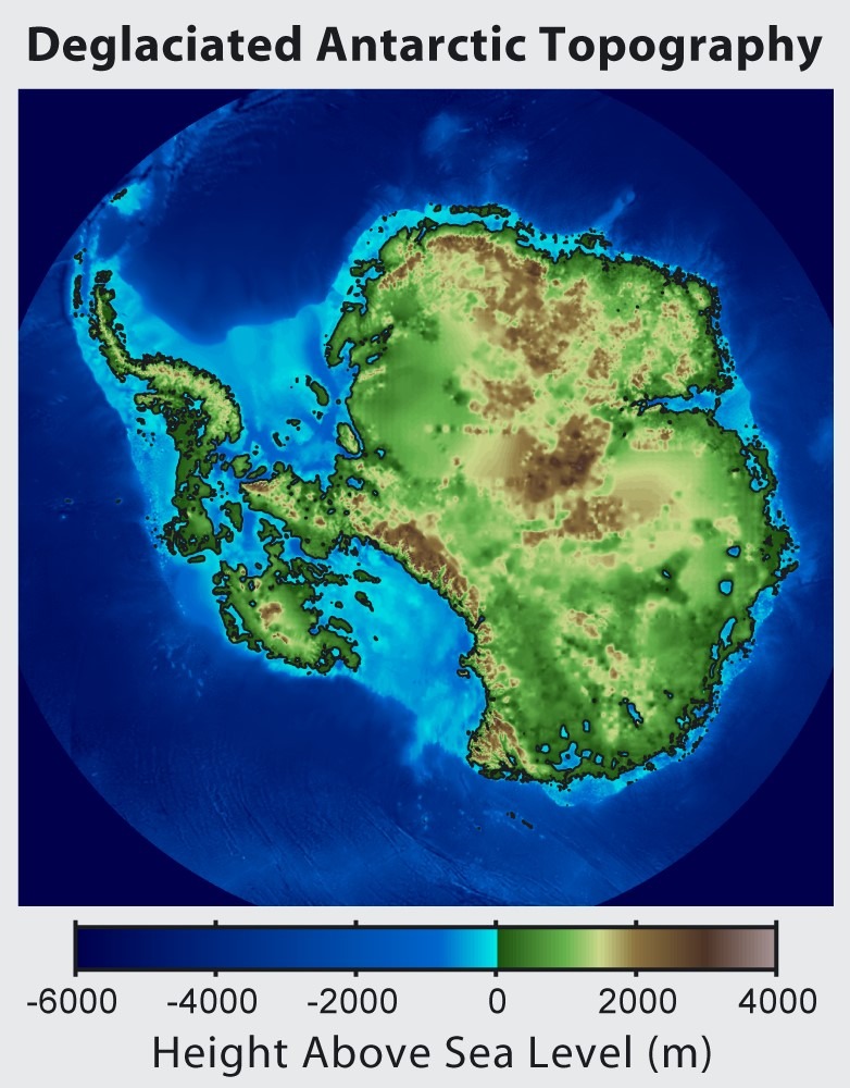
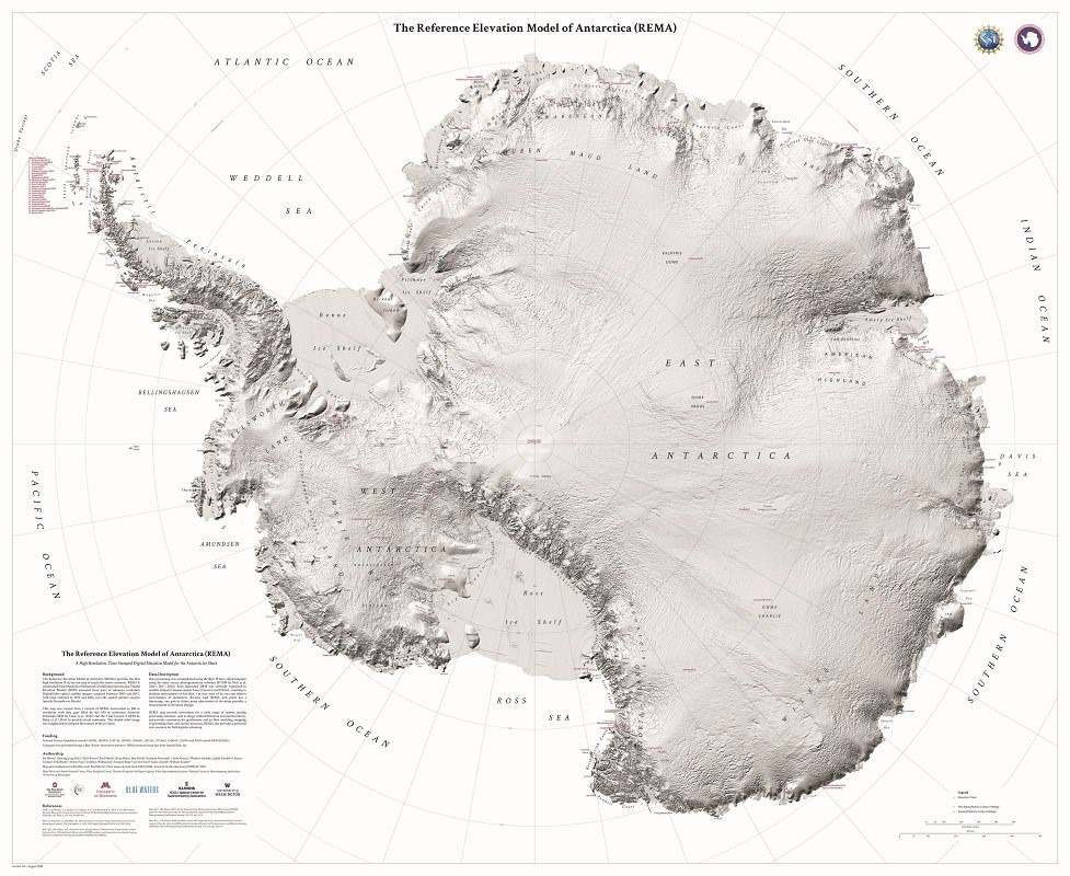
In 2018, scientists from the University of Minnesota, Illinois and Ohio completed the most advanced 8-meter resolution digital elevation model (DEM) of Antarctica to date. It was created using data from DigitalGlobe satellites acquired from 2009 through 2017. Most of the images were taken in 2015 and 2016. The project was named The Reference Elevation Model of Antarctica (REMA).
The difficulty in creating such a DEM is the very short survey season, from December to March. REMA can be used for a wide range of remote sensing data processing operations, such as orthorectification of images and interferometry, and provide data for geodynamic and ice flow modeling and surface process mapping. In addition, REMA opens up a powerful new resource for field logistics planning. Relief map of Antarctica
Exploring the North Pole
The North Pole is less interesting to researchers due to the lack of land beneath the ice. Since it is close enough to the northern countries, whose interest there is great, it can be studied not only from space images, but also directly on the ground. The circumpolar territories harbor huge reserves of minerals. Most likely, it is this aspect that will stimulate further study of the North Pole. Image of the digital elevation model of Antarctica (REMA)