of geospatial solutions
Sat-Sun: Non-working days
The creation of methods for complex computer processing of gravimetric survey and remote sensing data of the Earth to help to predict platinum–copper–nickel mineralization in new areas is an important problem.
The Bushveld Complex (the Republic of South Africa) is a reference data source for use during the creation of methods for forecasting and prospecting new deposits of platinum-group elements (PGEs) (Magmatic …, 1969). It contains more than 80% of the world reserves of PGEs and approximately 88% of the platinum reserves. These are allocated to three main levels (reefs): the UG2 chromitite horizon, the Merensky Reef, and the Platreef (Lazarenkov, 2002).
The main centers of platinum ore mining are located within the most studied Western sector of the Bushveld Complex (Atok, Rustenburg, Union, Bafokeng, Amandelbalt, Messina, Marikana, etc.) (Milovsky et al., 2016). Deposits of the Eastern sector (Brakfontein, Witerweld, Onverwacht, Twickenham, Richmond, and Der Brochen) are characterized by PGE contents in ores of 4–7 g/t (Du Toit, 1954).
The development of methods of computer processing of data of gravity surveys and of remote sensing of the Earth based on the example of ore deposits in the Eastern sector of the Bushveld Complex is very urgent for the solution of problems of forecasting platinum–copper–nickel mineralization in new areas.
The relevance of large-scale forecasting and prospecting for mineral resources, using remote (space and magnetometric-gravimetric) methods is related to the need for qualitatively new data on these objects without expensive field work (Chandra, 2008; Kronberg, 1988; Schowengerdt, 2007).
There are many theoretical and practical inventions for the integrated application of remote geophysical and space methods for oil and gas fields. However, the number of published works on the integration of geophysical and space methods for solid minerals is much smaller. Research on revealing platinum–copper–nickel deposits on the basis of remote methods is of great scientific and practical interest.
THE OBJECT OF RESEARCH
The Geological Characteristics of the Region
The Bushveld Complex (South Africa) is located in the north of the Kaapvaal Craton in the center of the Rand basin, which is composed of volcanic–sedimentary deposits of the Dominion-Reef, Witwatersrand, Ventersdorp, and Transvaal suites (Fig. 1). The total area of the pluton is approximately 6000 km2 and its thickness is 9000 m. The total complex consists of four apparently independent parts, while a fifth one is buried under younger sediments (Geologiya…, 1973).
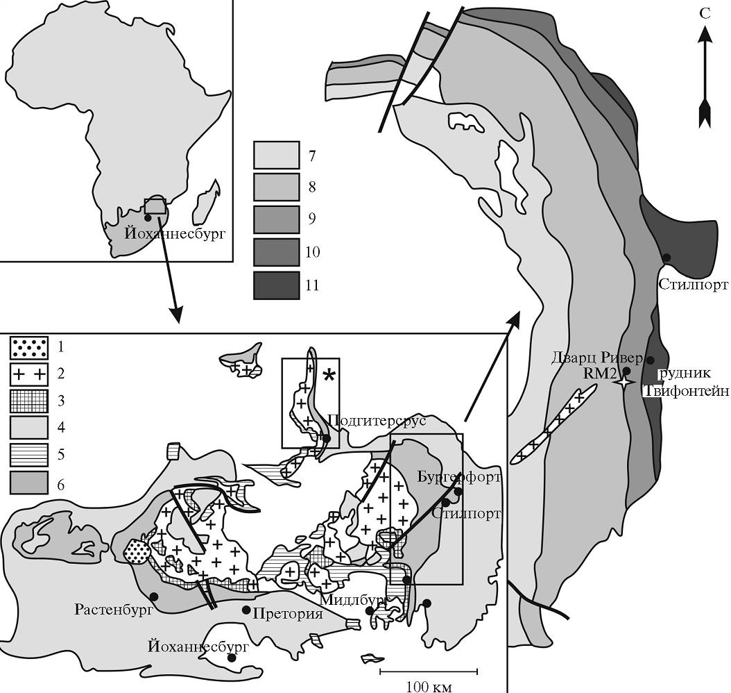
This igneous complex is a reference in the group of rhythmic-stratified massifs, and more than 80% of the world reserves of the total EPG and approximately 88% of platinum reserves are concentrated in it. These reserves are found in three main horizons: the UG2 chromitite horizon, the Merensky Reef, and the Platreef. The main centers of platinum ore mining are located within the most studied Western sector of the Bushveld Complex. The deposits of the Eastern sector are now actively explored and are ready for industrial development. In this connection, the prediction of platinum-metal mineralization based on the example of the Eastern sector of the Bushveld Complex is of great scientific and practical interest.
The Bushveld Complex includes several series of igneous rocks. The sequence of their formation is determined by geological and geochronological data (Cawthorn et al., 2002). The first intrusion phase is presented by mafic sills at the base of the host rocks. These are followed by an explosive phase, which forms the andesite–dacite–rhyolite layer of the Rooiberg group, which now represents the roof of the layered series. The next intrusive phase is the Rustenburg ultramafic–mafic layered suite, which is up to 8-km well as by late dikes and dolerite sills. Platinum-bearing reefs are revealed in the Rustenburg suite. They are represented by the UG2 chromitite horizon, the Merensky Reef, and the Bastard Reef, which form extended horizons of igneous rocks with strong ore mineralization (Williams, 1973).
Later, perhaps as a result of melting of the roof of the Rustenburg layered suite, Rashoop granophyre suites were formed. The Lebowa granites are considered to be the final phase. They overlap the Rustenburg layered suite in the central part of the complex and form bodies with a total thickness to 3 km under the layer of Rooiberg volcanites.
The intrusion period of all these magmatic formations is rather short: 1–1.5 million years (2054.4 ± 1.3 million years) (Scoates and Freidman, 2008; Zehet al., 2015). According to the zoning scheme adopted for the area of the Bushveld Complex, the western, eastern, northern, far western, and southeastern limbs are distinguished in it. The section of magmatic series in all these limbs is characterized by specific features (Cawthorn, 2002).
The Basal, Critical, Main, and Upper zones are specified within the Rustenburg ultramafic-mafic stratified series (from bottom to top). The Critical zone concentrates half of the world’s chromium reserves and includes three platinum-bearing reefs. The zone is 1.5–2-km thick and is divided into upper and lower subzones. The boundary between them is determined by the first appearance of cumulus plagioclase in the section. The lower subzone is dominated by pyroxenites with a small number of harzburgite and chromitite horizons. The upper subzone is represented by alternating layers of pyroxenites, norites, anorthosites, and chromitites. The UG2 platinum-bearing chromitite horizon is seen in the upper part of the Critical zone. The Merensky Reef, with a thickness that ranges from 40 cm to 6 m in different parts of the Bushveld Complex (Kinnaird et al., 2004), is found above the UG2 horizon.
The Merensky Reef is a unique horizon of plagioclase pyroxenites (often pegmatoid), in which minerals of platinum, gold, and silver associated with sulfide mineralization are concentrated (Naldrett, 2003, 2004). The reef is traced in the upper Critical zone at the boundary with the Main zone of the Rustenburg ultramafic-mafic layered suite.
MATERIALS AND METHODS
Interpretation of Space Survey Materials
Methods of computer processing of data of gravimetric, magnetometric, and space surveys were created to reveal the patterns of the localization of platinum-metal mineralization in the Eastern sector of the Bushveld Complex on the basis of data from Landsat 7 ETM+ multispectral space surveys in combination with analysis of geological and geophysical maps of the region. The data were processed using ENVI, ArcGis, and Adobe Photoshop specialized software products (Fig. 2).
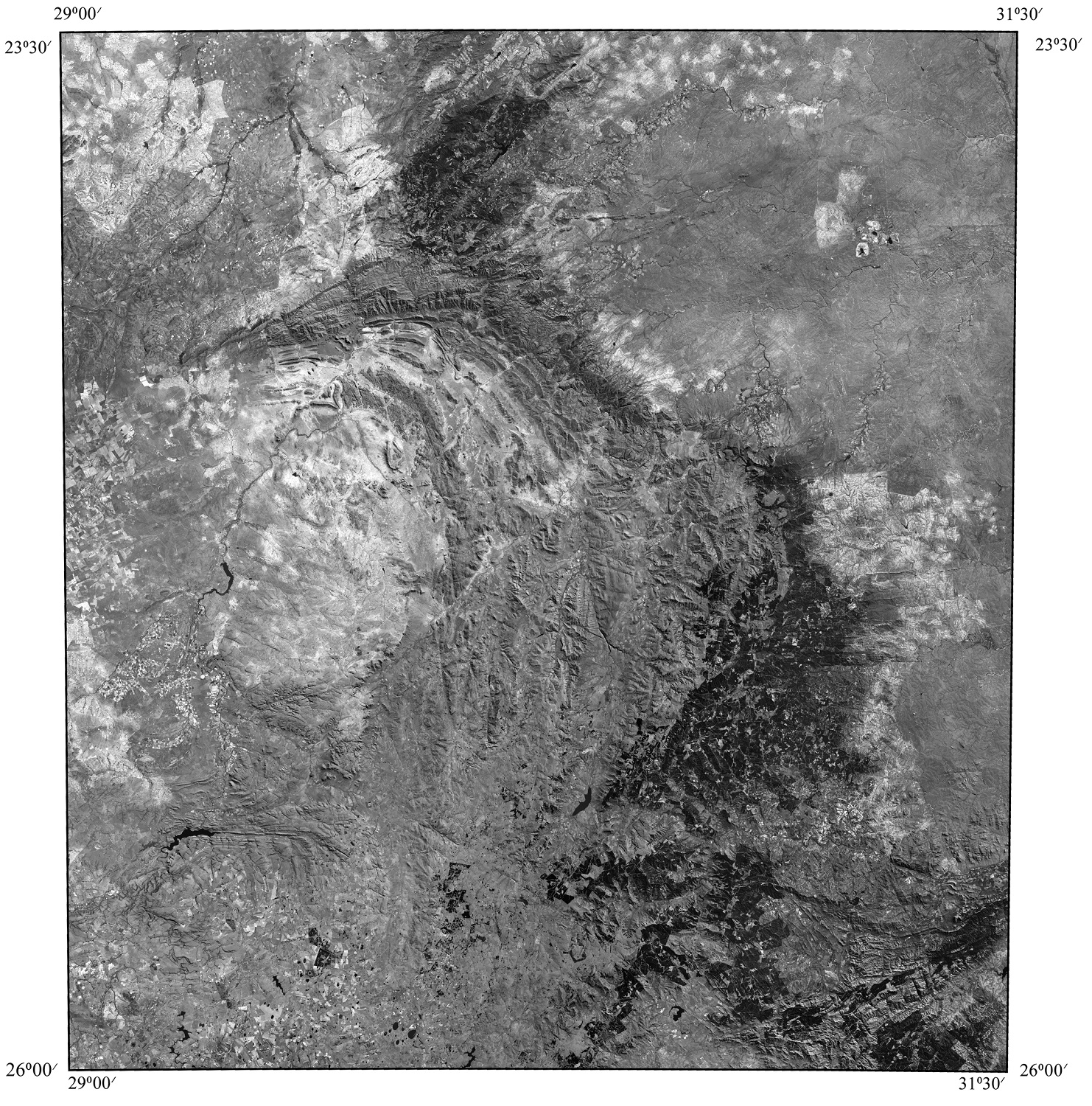
The abilities of LANDSAT 7 ETM+ multi-spectral space surveys were analyzed to solve problems of the recognition of geological objects on the background of host rocks and to assess their potential ore content. Space surveying was chosen for the research because the compilation of the State Geological Maps of Russia at a scale of 1 : 1000000 (3rd ed.) is informed by a remote database formed by digital materials of LANDSAT 7 ETM+ space surveys (Metodicheskoe …, 2009; Trebovaniya …, 2012).
The brightness parameters in channels 1 (0.45–0.52 μm, visible), 2 (0.52–0.60 μm, visible), 3 (0.63–0.69 μm, visible), 4 (0.76–0.90 μm, near infrared), 5 (1.55–1.75 μm, mid-infrared), 6 (10.40–12.5 μm, thermal), 7 (2.08–2.35 μm, mid-infrared), and 8 (0.52–0.90 μm, panchromatic) were used to analyze the data of LANDSAT 7 ETM+ space surveys. The digital materials were processed using the specialized ENVI 4.8 program, which provided a complete cycle of data processing from the spatial reference of an image to obtaining the necessary data.
The properties of objects that are directly or indirectly reflected on photographs and provide their recognition are taken as interpretation criteria. Their use is the basis of visual interpretation, which is the main method of obtaining data from images along with measurements. The properties of objects that are reflected on photographs are direct interpretation features. They occur in three groups: geometric (shape, shadow, and size), brightness (phototone, brightness level, color, and spectral image), and structural (lineament analysis) groups.
RESULTS AND DISCUSSION
Regional structures and linear arc faults were revealed as a result of structural interpretation. Fault structures (complicated lineament zones) were revealed within the Eastern sector of the Bushveld complex; they determine the spatial location of the Merensky Reef.
This is related to the fact that the Bushveld lopolith, which could better be called a supersill according to its morphological parameters (the length from the west to the east is 480 km, the thickness is approximately 9 km, and the ratio between the length and the thickness is 53 : 1), filled the compensatory brachysyncline together with Transvaal sediments. Residual acid melt, which later penetrated through the same channels probably from the same magmatic center, entered the roof of the crystallized norite lopolith and formed the so-called Bushveld red granite. Its mass caused a centrifugally oriented stress in the peripheral endoand exocontact zones of the norite lopolith. As a result, a system of low-amplitude faults of the shear kinematic type occurred in these zones and was accompanied by the formation of radial fractures. The chromitite horizon and the Merensky Reef were broken and displaced by radial disjunctives in many places, which is recorded both during the analysis of geophysical fields and during the interpretation of space survey materials (Milovsky, 2016).
Numerous displacements of the Merensky platinum-bearing reef along the system of linear fractures of the northeastern direction were revealed at the interpretation of multispectral Landsat 7 ETM+ satellite images of the Eastern sector of the Bushveld Complex. The location of the Merensky Reef, which is determined by the local lineaments, is clearly fixed by the data from Landsat 7 ETM+ multispectral space surveys and during the interpretation of geophysical fields.
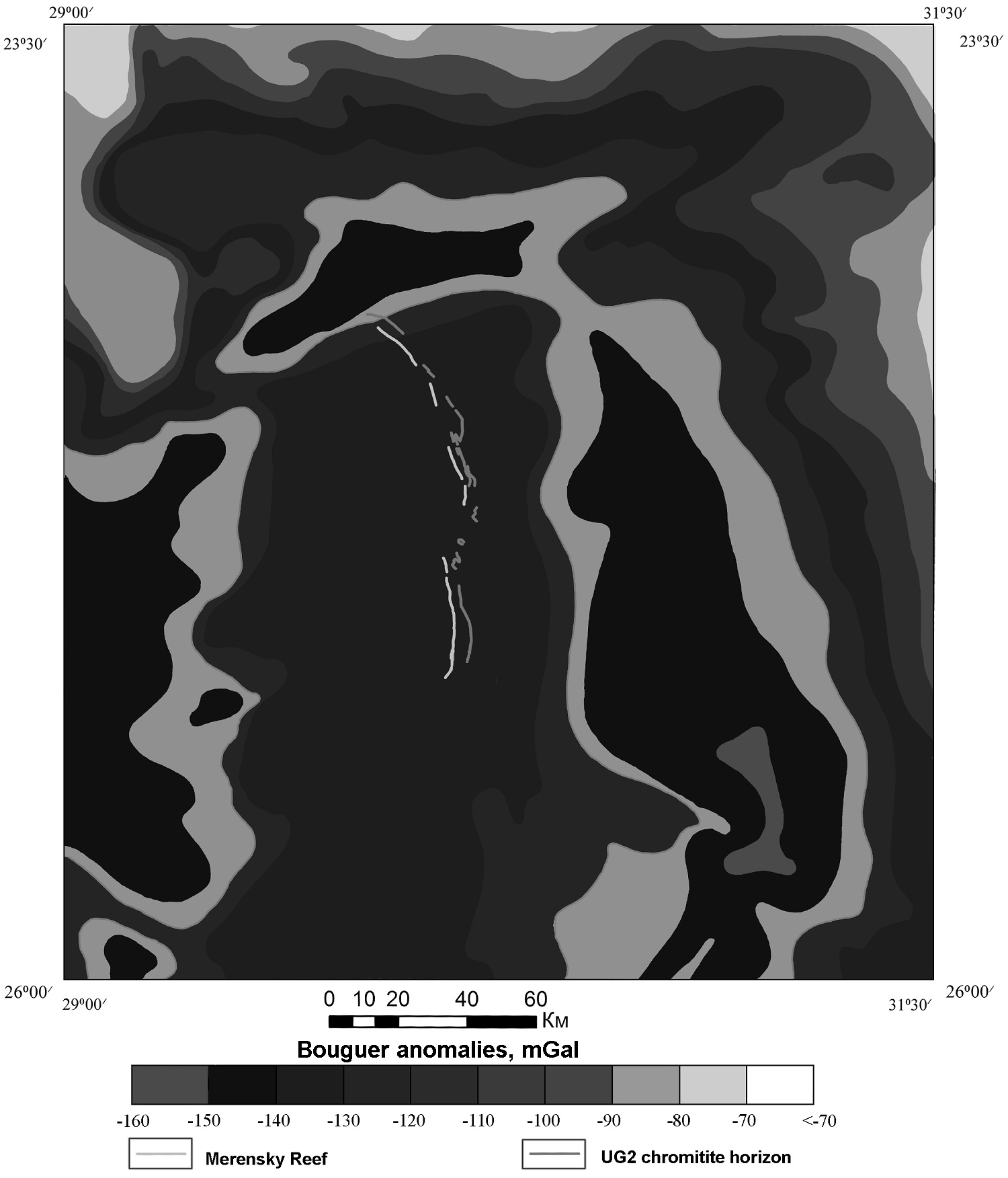
The analysis of the map of the gravitational field shows that platinum mineralization in the studied area corresponds to values from –70 to –120 mGal (Fig. 3). The isolines of the gravitational field follow the contours of the Eastern side of the Rand basin. The local arc and ring structures are characterized by low values of the gravitational field, that is, to –160 mGal.
We also analyzed the possibility of using Landsat 7 ETM+ multispectral space surveys to evaluate the brightness of rocks that contain this mineralization type (Table 1). The parameters of brightness are determined as the initial values in each pixel of the image and are given in DNs (Digital Numbers). These are dimensionless values, which are proportional to the amount of radiation that enters the sensor; they characterize the energy flow (watts) per square meter of the earth surface, per steradian (three-dimensional angle from a point on the earth surface to the sensor), and per unit of the measured wavelength (Schowengerdt, 2007). The spatial resolution is 30 m for channels 1–5 and 7, 60 m for channel 6, and 15 m for channel 8.
The ability to grade the rocks of the norite complex in the Eastern sector of the Bushveld Complex by remote sensing data is shown in Fig. 3. On the basis of the geological map at a scale of 1 : 1000000 (The 1 : 1000000 Geological Map..., 1984) and with account for the data of space surveys, the following areas were chosen: (1) the Upper zone, (2) the Main zone, (3 and 4) the Critical zone with and without chromitite layers, and (5) the Basal zone. Evaluation of the brightness parameters by the F- and t-criteria has shown that channel 2 (0.52–0.60 μm, visible) is the most informative for rock grading.
All the areas were compared in pairs on the basis of the statistical Fisher (F-criterion) and Student (t-criterion) criteria to determine the significance of brightness differences in the ranges of LANDSAT 7 ETM+ space surveys. All the calculations were performed for a significance level α = 0.01, which corresponds to 99% confidence in the conclusions (Ishmukhametova, 2015). The F-criterion is based on the comparison of variances:
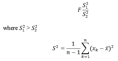
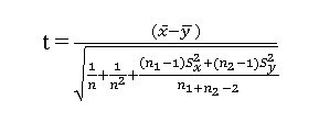
If the calculated t-criterion is greater than the tabular value at the α = 0.01 significance level, the difference between the two samplings in the given range of space survey is considered significant.
The synthesis of spectral ranges of Landsat 7 ETM+ and features of brightness parameters in particular ranges revealed a series of rocks of the norite complex on the background of the overlying and underlying rocks and allowed us to grade the rocks of the norite complex into the Basal, Critical, Main, and Upper zones.
The obtained data based on the example of the Eastern sector of the Bushveld Complex provide new opportunities for improving the methods of prediction and prospection of platinum–copper–nickel deposits. The fact should be taken into account that it was not only mantle centers that played an important role in the structure of ore-forming systems; large long-term fault structures (long-term complicated deep lineament zones) also controlled the periodic flow of fluids-heat carriers and accompanying substances, including ore components, from deep layers of the Earth (Gruenewaldt von, 1973).
The use of multispectral Landsat 7 ETM+ images for geological studies enabled us to determine the composition of rocks and geological boundaries, to create a structural-tectonic scheme, and to reconstruct the geological structure. This methodology may be used during geological research of other poorly studied areas with similar geomorphologic and landscape-climatic conditions.
CONCLUSIONS
(1) It has been determined that platinum mineralization in the studied area is characterized by values of the gravitational field from –70 to –120 mGal.
(2) The data from the cosmic structural interpretation enable one to distinguish post-ore fault structures (complicated lineament zones) in the Eastern sector of the Bushveld Complex, which often determine the location of the Merensky Reef.
(3) Synthesis of the spectral ranges of Landsat 7 ETM+ space images and brightness parameters in particular ranges enable one to reveal rocks of the norite complex on the background of overlying and underlying rocks in the Eastern sector of the Bushveld Massif and to distinguish the Basal, Critical, Main, and Upper zones of rocks of the norite complex.
(4) The Landsat 7 ETM+ multispectral space survey and brightness parameters are informative for predicting platinum-metal mineralization in new promising areas.
Sat-Sun: Non-working days