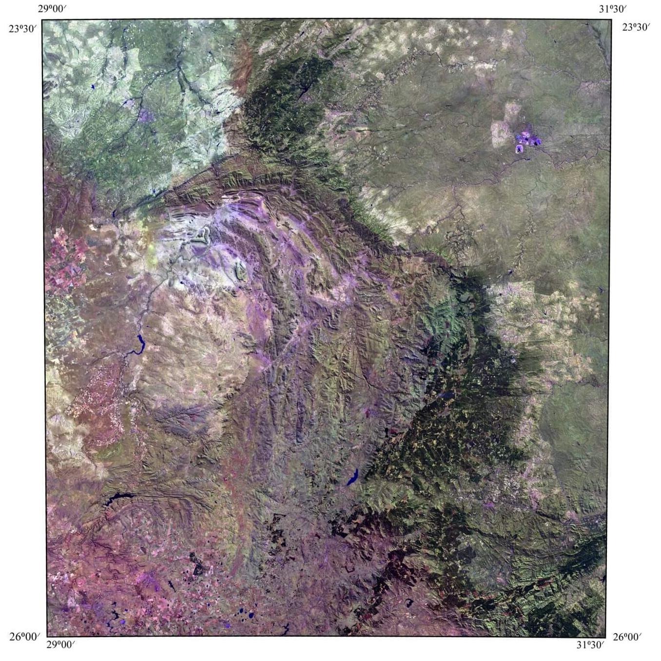
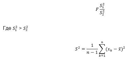
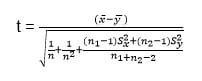
If the computed t-test value was greater than the tabular value at a significance level of α = 0.01, the difference between the two samples of this range of satellite imagery was considered significant. Synthesis of Landsat 7 ETM+ spectral ranges and the characteristics of brightness in individual ranges allow identification of the aggregate of norite complex rocks against the background of overlying and underlying rocks. Additionally, it allows for the classification of norite complex rocks into Basal, Critical, Main, and Upper zones.
The data obtained from the Eastern sector of the Bushveld Complex reveal new opportunities for improving methods of forecasting and prospecting for platinum-copper-nickel deposits. It should be noted that large, long-lived fault structures (complexly constructed deep-seated lineament zones) played a significant role in the structure of ore-forming systems, controlling the periodic influx of fluids-heat carriers and associated substances, including ore components [Gruenewaldt von, 1973]. Thus, the use of multi-zone Landsat 7 ETM+ imagery for geological studies has enabled determination of rock compositions, geological boundaries, and structural-tectonic mapping, reconstructing geological structures. The developed methodology can be used for geological research in other poorly studied areas with similar geomorphological and landscape-climatic conditions.
Conclusions
-
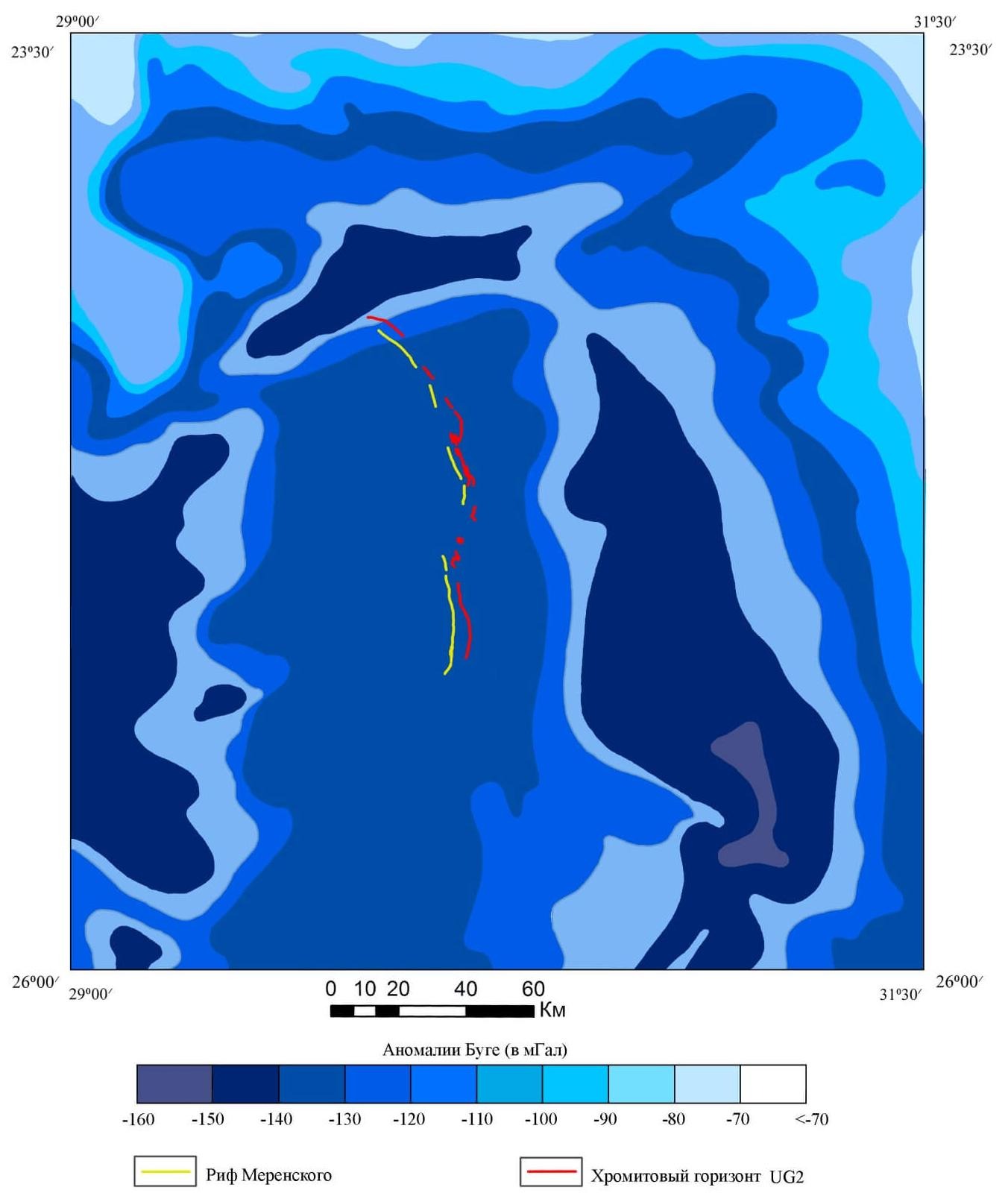
It was established that within the study area, platinum-metal mineralization is concentrated in the gravity field values ranging from -70 to -120 mGal.
-
Within the Eastern sector of the Bushveld Complex, space structural decoding indicates the presence of post-rupture fault structures (complexly constructed lineament zones), which often determine the spatial position of the Merensky Reef.
-
Synthesis of Landsat 7 ETM+ spectral ranges and the characteristics of brightness in individual ranges allow for the identification of the aggregate of norite complex rocks in the Eastern sector of the Bushveld massif against the background of overlying and underlying rocks, and furthermore, allows for the breakdown of norite complex rocks into Basal, Critical, Main, and Upper zones.
-
For forecasting platinum-metal ore deposits in new prospective areas, it is advisable to use multi-zone Landsat 7 ETM+ satellite imagery and brightness characteristics.
References
1. Geology and Mineral Resources of Africa. Moscow: Nedra, 1973. 544 p.
2. Ishmukhametova V.T. Forecasting of primary diamond deposits on the North Siberian Platform based on the interpretation of satellite imagery materials: PhD thesis in Geological and Mineralogical Sciences. Moscow, 2016.
3. Kronberg P. Remote Sensing of Earth: Basics and Methods of Remote Sensing in Geology. Moscow: Mir, 1988. 343 p.
4. Lazarenkov V.G., Petrov S.V., Talovina I.V. Platinum Metal Deposits. Moscow: Nedra, 2002. 298 p.
5. Magmatic Ore Deposits. Lancaster, USA, 1969. Translated from English under the editorship of Academician V.I. Smirnov. Moscow: Nedra, 1973. 208 p.
6. Methodological guide for the compilation and preparation for publication of sheets of the State Geological Map of the Russian Federation at a scale of 1:1,000,000 (third generation). – St. Petersburg: VSEGEI, 2009. 288 p. + graphic appendices 49 sheets. (Ministry of Natural Resources of Russia, Rosnedra, VSEGEI).
7. Milovsky G.A., V.N. Orlyankin, V.T. Ishmukhametova, Shemyakina E.M. Application of remote sensing results to identify patterns of platinum-metal ore formation in the Western Bushveld. Earth Research from Space, No. 6, 2016, pp. 21-34.
8. Naldrett A.J. Magmatic sulfide deposits of copper-nickel platinum metals. St. Petersburg: SPbSU, 2003. 487 p.
9. Requirements for the advanced geophysical basis of the State Geological Map of the Russian Federation at a scale of 1:1,000,000 (third generation, second edition). – Moscow-St. Petersburg: Rosnedra, 2012. – 23 p. + 3 inserts.
10. Willemz J. Geology of the Bushveld Complex – the largest repository of magmatic ore deposits in the world // Magmatic Ore Deposits: Translation from English. Moscow: Nedra, 1973. pp. 86–98.
11. Chandra A.M., Gosh S.K. Remote Sensing and Geographic Information Systems. – Moscow: Technosphere, 2008.
12. Shvengardt R.A. Remote Sensing. Models and Methods of Image Processing. – Moscow: Technosphere, 2010.
13. Du Toit Alex L. The Geology of South Africa. Oliver and Boyd, London, 1954.
14. Geological Map of the Republics of South Africa, Transkei, Bophuthatswana, Venda and Ciskei, and the Kingdoms of Lesotho and Swaziland. Geological Survey of South Africa. Department of Mineral and Energy Affairs. (Geological Map. Scale 1:1,000,000). 1984.
15. Von Gruenewaldt G. The mineral resources of the Bushveld Complex // Minerals Science and Engineering. 1977. Vol. 9, No. 2. pp. 83–95.
16. Naldrett A.J. Magmatic Sulfide Deposits: Geology, Geochemistry and Exploration. Springer Verlag, 2004. p. 728.
17. Cawthorn R.G. The role of magma mixing in the genesis of PGE mineralization in the Bushveld Complex. Thermodynamic calculations and new interpretations – a discussion // Economic Geology, 2002. Vol. 97. pp. 663–666.
18. Kinnaird J.A., Kruger F.J. Excursion Guide to the Bushveld Igneous Complex. Geoscience Africa, University of the Witwatersrand, 2004. pp. 1-23.
19. Scoates J.S., Friedman R.M. Precise age of the platiniferous Merensky reef, Bushveld Complex, South Africa, by U-Pb zircon chemical abrasion ID-TIMS technique // Econ. Geol. 2008. Vol. 103. pp. 465-471.
20. Zeh A., Ovtcharova M., Wilson A.H., Schaltegger U. The Bushveld Complex was emplaced and cooled in less than one million years – results of zirconology, and geotectonic implications // Earth Planet. Sci. Lett. 2015. Vol. 418. pp. 103-114.



![Figure 1. Schematic geologic map of the Bushveld Complex, by [Kinnaird et al., 2004]: 1 - alkaline intrusions; 2 - Lebov granites; 3 - Rashup granophyres; 4 - Transvaal supergroup; 5 - andesite-dacite-rhyolites Roiberg; 6 - Rustenburg stratification](/upload/iblock/ec5/1-_1_.jpg)