Ecosystem of the Lake Baikal basin: Digital map and geoinformation database
Results of Remote Sensing in the Ecology of Lake Baikal and Its Coastal Zone, River Basins, and Forest Area Over the Past Decade
Recreation on Lake Baikal
Recreation, as a significant human activity, is depicted on the map as a holistic phenomenon. The degree of territorial development of recreational activities is reflected through zoning (natural and socio-natural recreational zones). Zone boundaries correspond to the 1500 m contour line, determined by natural-landscape differentiation. Five levels of maximum allowable density (people/ha/day) have been identified.
District and settlement zoning of recreational areas (main and additional recreation centers) are key aspects, considering the typology of destinations and their specialization in forms and types of recreational activities.
Evaluation of coastal landscapes for recreational activities.
Naturally untouched landscapes directly and comprehensively satisfy the needs for physiologically necessary recreation (unconscious-reflexive), such as contemplation, solace, relaxation, etc. These landscapes (groups of landscapes) must be protected. The most accessible part of the Baikal coast demonstrates a certain degree of transformation of the surrounding environment. Socially specific (purposeful and conscious) forms of recreation predominate in these areas. The accumulation of problems associated with anthropogenic impact leads to landscape degradation and even loss of landscape diversity and complete uselessness of the territory in terms of recreation needs satisfaction.
The map shows the types and subtypes of natural landscapes within the Central Ecological Zone of Lake Baikal. It also illustrates areas of natural resource use, where comprehensive goals of landscape and territorial planning (preservation, improvement, development), as well as areas for protection and reclamation, must be achieved.
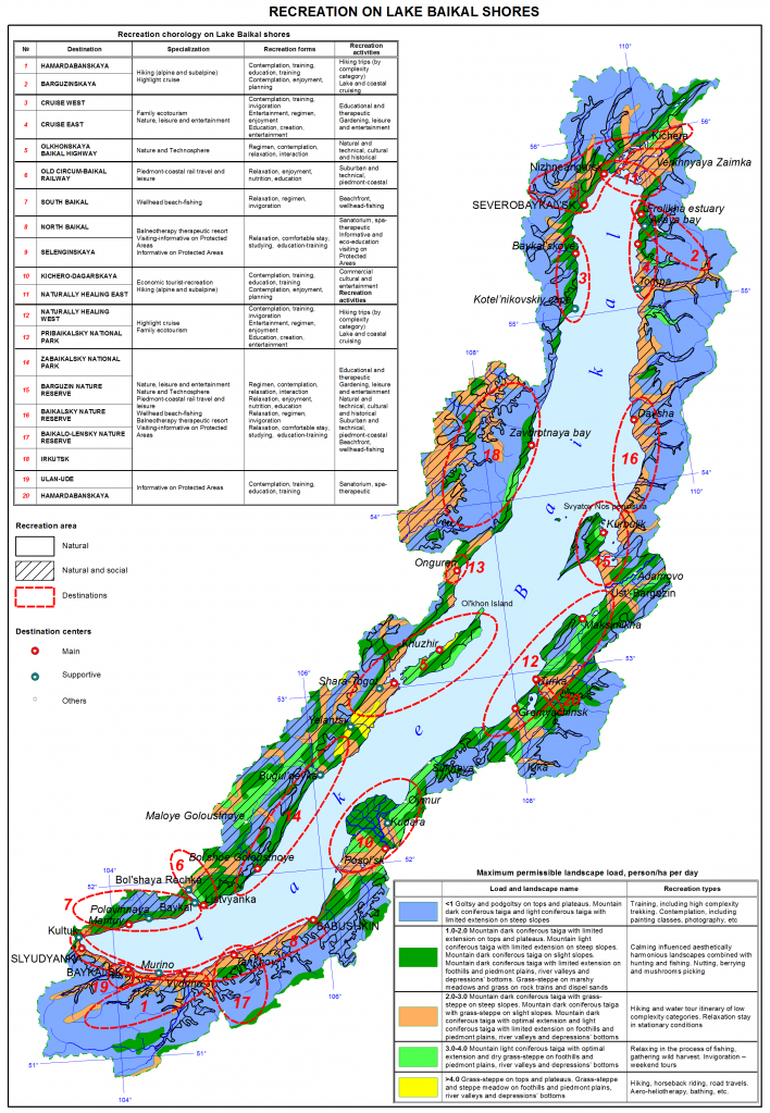
Fig. 5 Map of recreation zones along the shores of Lake Baikal
Digital Monitoring of the Baikal Natural Territory
The project's goal is to create a pilot network of digital monitoring stations for hydrological and hydrochemical conditions of Lake Baikal and its tributaries. In 2020, automated water level monitoring was organized in the lower and upper reaches of the Slyudyanka River using hydrostatic level sensors. In 2021, automated hydrometeorological stations were installed on the Irkut, Selenga, and Barguzin rivers.
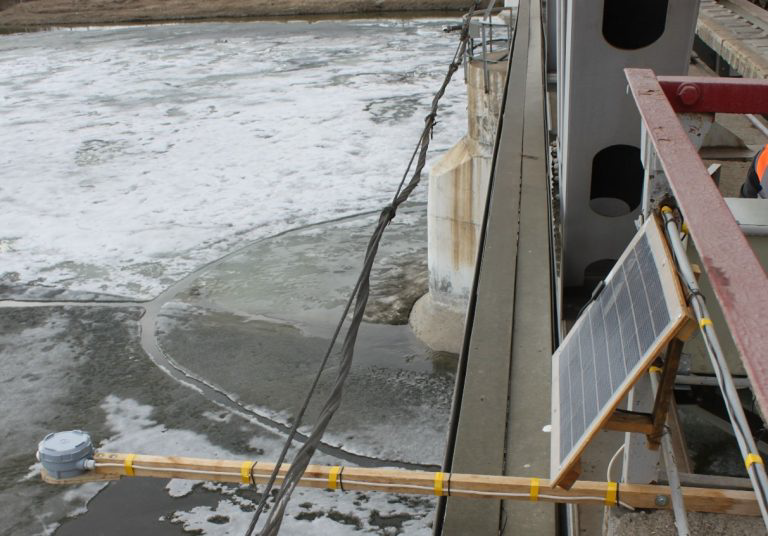
Fig. 6 Installation of radar level sensor and solar panel on a railway bridge
Thus, an online monitoring system of hydrophysical, hydrological, and meteorological parameters of the Baikal ecological zone has been implemented, consisting of two stations located in two areas with different degrees of anthropogenic load.
In 2021, monitoring studies were conducted on the single outflow of Lake Baikal – the source of the Angara River, which reflects the total chemical composition of Lake Baikal water.
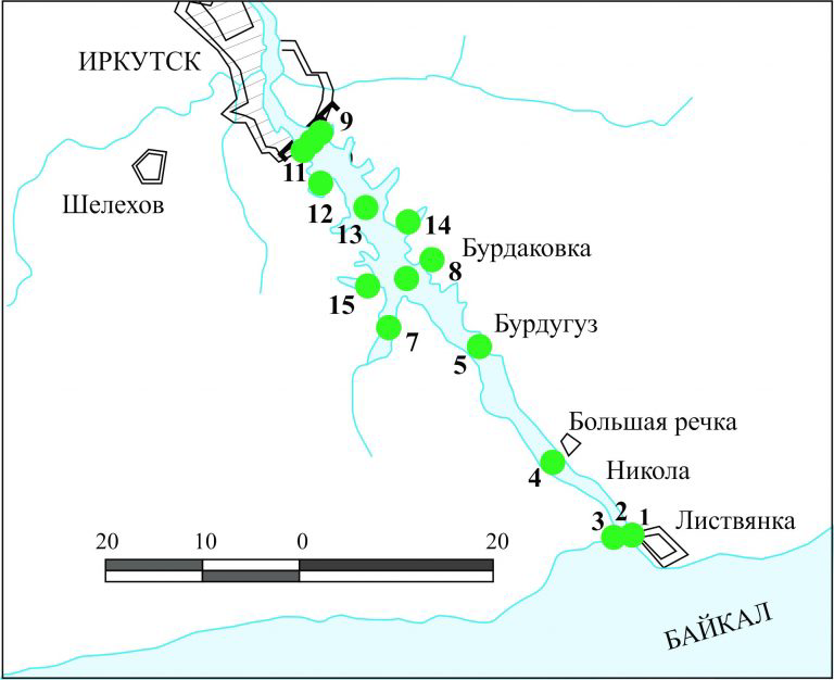
Fig. 7 Map-scheme of sampling at the source of the Angara River and the Irkutsk Reservoir
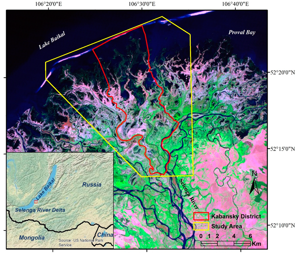
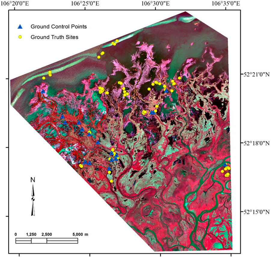
To study the state of water bodies of the Selenga River and the transformation of substances in aquatic ecosystems, the chemical composition of surface waters and bottom sediments of streams and lakes in the delta of the Selenga River was determined.
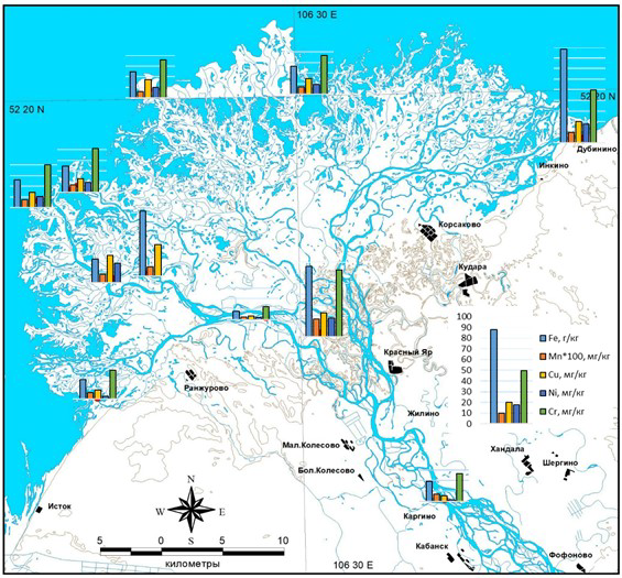
Fig. 8 Content of heavy metals in bottom sediments of the Selenga River, streams, and lakes of the delta in 2021
Thus, the beginning of installing ground remote sensors in complex ecological water areas of Lake Baikal lays the foundation for the regular observation system.
Experience in Using UAVs
In recent years, unmanned aerial vehicles (UAVs) have begun to be used and have proven themselves well in visualizing rapidly changing natural and anthropogenic environments. They are capable of monitoring changes in the shoreline with decreasing Lake Baikal levels, monitoring gully formation, fire and post-fire situations in forests and peatlands, conducting surveys of small salt lakes, dunes, sand dunes, snow-covered fields, residential buildings, agricultural fields, irrigation systems, roads, archaeological sites, quarries, etc.
Special programs (e.g., Agisoft) create 3D models and orthophotoplans. These models are then exported to mapping programs (ArcGIS, etc.) where they are used as full-fledged cartographic products to create detailed topoplanes.
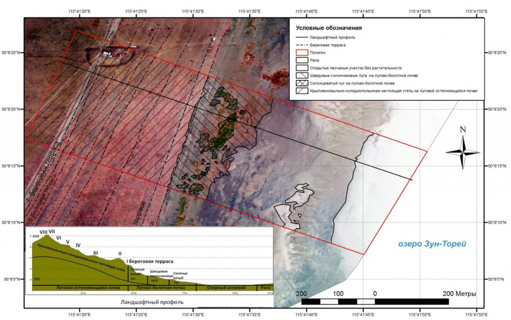
Fig. 9 Eight ancient terraces of Lake Zun-Torey and landscape profile near the Teli camp
UAVs offer advantages in cost-effectiveness and obtaining high-resolution images quickly; orthophotoplans obtained with UAVs are a good analog to satellite images for small areas (up to several square kilometers). Future perspectives include using UAVs with other instruments: echo sounders, 3D terrestrial laser scanning station Leica ScanStationC10, electronic tachymeters, etc.
Monitoring Changes in Natural Complexes of the Southwest Coast of Lake Baikal Using Ground Observations and UAV Aerial Photography (Case Study: Listvyanka Village and Its Surroundings)
The natural complex of Listvyanka village and its surroundings has been significantly altered by human economic activities.
The aim of the study is to assess changes in the natural complexes of the village and its surroundings using ground methods and research with unmanned aerial vehicles.
Objects and methods of research. The objects of detailed study include soil and snow cover, surface and underground waters in the village and in the waters of Lake Baikal, within the influence zone of the settlement. Soil, snow, and water samples were collected, and chemical-analytical work was conducted using standardized and widely accepted methods.
Thus, the use of traditional (ground-based) physico-chemical methods in combination with unmanned aerial vehicles in monitoring studies of natural complexes allows for an expanded understanding of ongoing processes and phenomena. UAV operations are feasible in natural-landscape conditions of any complexity.
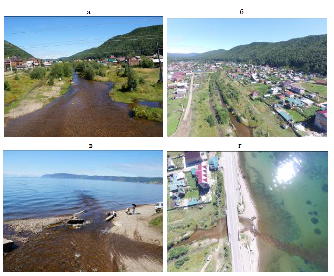
Fig. 10 Crossroads estuary: photography towards the village (a) and from the Phantom 3 Advanced quadcopter (height 54 m); inflow into Baikal: photography (c) and quadcopter shot (g) (height 240 m).
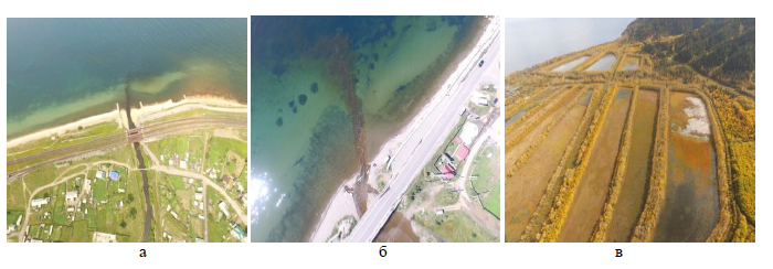
Fig. 11 Pollution discharge of the Mysovka River (a), suspended matter discharge of the Krestovka River (b), settling tanks of the BTC (c).
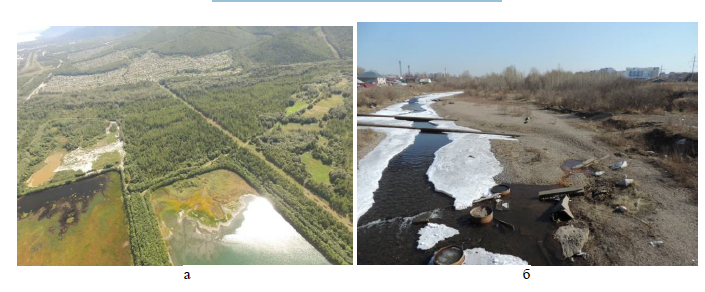
Fig. 12 Formation of landfill sites at BTC settling tanks (a), pollution of the floodplain and channel of the Ushakovka River (b).