The military sector encompasses military service, weaponry, combat training (including special operations), conducting combat operations, and all military and auxiliary support for the armed forces from various state sectors, both in peacetime and during wartime.

The world's largest nations maintain and develop their military-industrial complexes. The Military-Industrial Complex (MIC) is a combination of manufacturing enterprises, research and testing organizations engaged in the development, production, storage, and deployment of military and specialized equipment, ammunition, and weaponry, primarily for state security forces and export.

In the United States and NATO, significant emphasis is placed on workforce development within the MIC, attracting talent from other countries to support weapon innovation. Government mechanisms facilitate this recruitment, removing barriers to ensure military superiority over adversaries.

Annual global military expenditures amount to hundreds of billions of USD.

Global military expenditures by region, 1988-2021
Fig.1 Global military expenditures by region, 1988-2021

The United States is the largest financial player in this sector. Annually, it spends over USD 850 billion, including "black budget" funding allocated through various government agencies.

In 2021, global military spending increased by 0.7% in real terms, reaching USD 2.113 trillion.

The military doctrines of the U.S., NATO, Australia, and China, along with their ongoing exercises and real combat operations, demonstrate that the geospatial component in modern warfare is not just significant but decisive in achieving enemy defeat.

For example, U.S. intelligence expenditures reach up to USD 80 billion. In 2021, geospatial intelligence (GEOINT) spending accounted for 87% of the entire U.S. intelligence community's (17 agencies) total intelligence budget.

The global application of geospatial technologies in military affairs is concentrated in geospatial intelligence (GEOINT), which provides intelligence data (remote sensing data) and analytical solutions to all branches of the armed forces for combat decision-making.

Structure of U.S. Geospatial Intelligence
Fig.2 Structure of U.S. Geospatial Intelligence and related value-added products and operational directions

What Tasks Does Remote Sensing Solve?

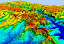
The key objective of remote sensing (RS) in military applications is to create conditions for high-precision targeting of any stationary or mobile enemy target in real-time, based on a 3D model generated from RS data anywhere on Earth.

This task is driven by geospatial intelligence (GEOINT), which involves observing, detecting, decoding, tracking, and accurately georeferencing targets and delivering this data to the weapon system operator for battlefield decision-making.

The tasks should be categorized based on peacetime and wartime operations, as well as strategic, operational, and tactical levels.

Peacetime:

  • Global intelligence monitoring of military and civilian situations, compiled into NGA data. NGA data is a key strategic asset that supports decision-making and mission execution at all levels. From modern fighter pilots to policymakers, rapid data delivery and analysis provide a decision-making advantage over adversaries.
  • Volume of network analysis in U.S. geospatial intelligence, 2021
    Fig.3 Volume of network analysis in U.S. geospatial intelligence, 2021
  • Strategic GEOINT objectives of the U.S. and NATO include monitoring nuclear storage facilities, missile silos, mobile nuclear forces, and nuclear submarines in ports and global waters.
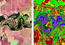
  • Collecting intelligence on enemy infrastructure and terrorist organizations, including building textures, residential structures, transportation networks (especially metro systems), telecommunications, command centers, factories, research institutes, logistics, and their classification for military action prioritization.
  • Daily operational management of RS data by the U.S. Department of Defense: planning, topographic and thematic mapping, global navigation services, aviation situation monitoring, and coordination of 3,000 military flights daily.
  • Providing warnings through NGA, which monitors global hotspots and delivers timely alerts to military personnel and national decision-makers about imminent threats.
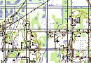
  • Development of real-time transition platforms from digital maps to realistic 3D target models. The military reliance on topographic and thematic maps has decreased to 30% in overall geospatial intelligence representation.
  • Target georeferencing using a 3D model
    Fig.4 Target georeferencing using a 3D model
  • Support for military exercises, test ranges, troop redeployments, new base construction, and maintenance of military infrastructure domestically and abroad.
  • Accurate geospatial data overlay: GEOINT enables advanced applications that analyze exact locations of billions of mobile phone users, transaction points, online activities, and maritime cargo tracking.
  • Disaster relief: NGA supports U.S. federal agencies such as FEMA and the State Department in humanitarian and disaster relief missions, providing RS intelligence during typhoons, floods, earthquakes, and industrial accidents.
  • Secure transmission of geospatial intelligence through SATCOM, Intelsat, Inmarsat, Thuraya, Internet, HF, and VHF channels, with compression for low-bandwidth environments.

RS-Based Geospatial Analysis for UAVs:

  • Real-time or near-real-time UAV tracking.
  • 3D visualization of UAV positions, field of view, coverage areas, and flight paths.
  • Retrieval of UAV information (ID, name, altitude, tilt angle, etc.).
  • Automatic geolocation of UAV positions and camera focal points with 2-6 cm pixel resolution.
  • Weather condition tracking during UAV operations.

Wartime:

  • Full-scale geospatial intelligence of the battlefield (AO), airspace, maritime areas, and submarine movements using space-based, aerial, UAV, mobile, ground-based, and man-portable systems.
  • Automated GEOINT processing onboard satellites/UAVs with direct transmission to the battlefield.
  • Real-time data delivery for precision strikes with minimal munition expenditure per target.
  • Geospatial modeling of nuclear strikes, their aftermath, and strategic troop movements.
  • Monitoring enemy logistics, troop deployments, and economic infrastructure during combat.
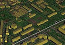
  • Targeting through 3D models with real-time texture updates in urban and remote combat zones.
  • Stereo imaging and 3D mosaics for urban GEOINT
    Fig.5 Stereo imaging and 3D mosaics for urban GEOINT
  • AI-driven GEOINT analytics to assist tactical-level military personnel in battlefield decision-making.
  • Detection of enemy electronic warfare (EW) assets, geospatial tracking, and targeting for precision strikes.
  • GEOINT assessment of underwater conditions for submarine maneuvers in enemy waters.
  • Integrated command and control of military operations on a unified geospatial platform.
  • Real-time UAV video streaming with automatic geolocation of detected targets.
Automated tactical monitoring and UAV 3D modeling in combat
Fig.6 Automated tactical monitoring and UAV 3D modeling in combat

Advantages of RS in Military Applications:

  • A comprehensive geospatial system has been developed (U.S., NATO, China) to integrate military geospatial intelligence at national and commercial levels. It processes RS data across the electromagnetic spectrum with extreme precision (15 cm panchromatic, SAR; 50 cm multispectral from satellites; 1-3 cm from UAVs). AI-powered online analytics reduce decision-making time to under 10 minutes.
  • National Geospatial Intelligence System (NSG), U.S.
    Fig.7 National Geospatial Intelligence System (NSG), U.S.
    Real-time GEOINT analytics
    Fig.8 Real-time GEOINT analytics
  • Automated real-time 3D modeling of enemy environments for urban and remote battlefields. Plans for a global high-resolution 3D Earth model are in progress.
  • RS data is indispensable for precision-guided munitions in combat, as demonstrated in recent conflicts.
  • GEOINT is used for reconnaissance, monitoring, object detection, cargo verification, and civilian-military maritime operations.
  • The U.S. and NATO integrate ArcGIS at all GEOINT levels, supporting headquarters operations, battlefield management, and advanced military data processing through machine learning, photogrammetry, and AI-based analytics.
  • Partial transfer of military RS and GEOINT technologies to civilian and commercial sectors fosters geospatial innovation, driving advancements in AI, IoT, neural networks, and smart technologies.

Need for consultation?

Fill the form and we will contact you

By clicking the «Send» button, you give your consent to the processing of your personal data, in accordance with Federal Law No. 152-FZ of July 27, 2006 «On Personal Data», on the conditions and for the purposes specified in the Consent to the processing of personal data.

Customers

FAQ

Geospatial intelligence is the process of collecting and analyzing geographic data to obtain information about specific locations and areas on the Earth's surface. It involves the use of various technologies and methods, such as remote sensing, global positioning systems (GPS), geographic information systems (GIS), and aerial photography.

The main objective is to obtain detailed information about geographic objects and their characteristics. This may include measuring elevations, shapes, and sizes of the Earth's surface, analyzing terrain and landscapes, determining coordinates and georeferencing objects, as well as creating digital models and maps.

  1. Military Intelligence: Geospatial intelligence plays a crucial role in military operations, providing information on enemy force locations, terrain topography, infrastructure objects, and other important data for strategic planning and tactical actions.

  2. Civil Protection: Used for monitoring and analyzing natural disasters (floods, earthquakes, etc.), allowing assessment of the scale and consequences of disasters and coordinating rescue and relief operations.

  3. Scientific Research: Geospatial data helps scientists study climate change, ecosystems, landscapes, and other aspects of the Earth's surface.

  4. Geology and Mining: Geospatial data is applied in the search and evaluation of mineral deposits, as well as for planning mining operations and assessing the stability of geological formations.

  5. Agriculture: Geospatial data is used to monitor soil conditions, determine optimal locations for agricultural activities, control crop growth, and combat plant diseases.

  6. Transportation and Infrastructure Management: Geospatial data is used for planning road and transportation systems, traffic management, and detecting infrastructure issues (e.g., cracks in dams or bridges).

It has a wide range of applications. It is used in geology and geological survey to study the structure of the earth's crust, identify mineral deposits and search for oil, gas and other resources. In agriculture, it helps in farmland planning, monitoring yield levels and assessing vegetation cover. It also finds application in urban planning and city planning. It helps in determining the optimal placement of buildings and infrastructure, planning road networks, assessing resilience to natural disasters, and analyzing transportation accessibility. In defense and security, geospatial intelligence plays an important role. It helps analyze territories, control borders, detect facilities and enemy movements, and conduct reconnaissance before military operations.
Geospatial intelligence technologies and methods are constantly evolving, opening up new opportunities for obtaining more accurate and complete geographic information. They play an important role in various industries and contribute to more informed action and optimized processes. For example, using remote sensing and satellite navigation systems such as GPS, it is possible to obtain precise coordinates of objects and conduct accurate mapping of areas. This is particularly useful in planning infrastructure projects such as roads, bridges and buildings, where accuracy and spatial information play an important role. It is also used in environmental monitoring and assessment. Using specialized sensors and tools, water quality, soil conditions, vegetation distribution and climate change can be analyzed. This enables measures to be taken to protect nature, use resources sustainably and solve environmental problems.
One important application area of geospatial intelligence is transportation and logistics. GIS and specialized software solutions can be used to optimize delivery routes, manage cargo flows, track the location and condition of vehicles, and prevent conflicts and delays in transportation. This reduces costs, improves efficiency and ensures more reliable delivery of goods. Geospatial intelligence is also significant in civil security and emergency management. By analyzing geographic data, the effects of natural disasters such as floods, earthquakes, or wildfires can be modeled and predicted, and evacuation planning and rescue operations can be coordinated. In general, geospatial intelligence plays an important role in various industries and provides access to relevant, accurate and useful geographic information. Its application contributes to economic development, improving people's lives and ensuring the safety and sustainability of various processes and activities. By analyzing and interpreting geospatial data, it is possible to identify trends, patterns and relationships between different geographical phenomena and phenomena in other industries. In the construction industry, it contributes to more accurate planning and design of facilities. It can be used to analyze terrain, determine optimal locations for construction, monitor ground stability and prevent possible geological risks. The transportation industry also relies heavily on geospatial intelligence. It helps to optimize transportation routes, predict and prevent traffic jams and accidents, improve public transportation planning, and enhance transportation safety and efficiency. Geospatial intelligence also has applications in environmental monitoring and conservation. It allows analyzing changes in ecosystems, detecting pollution, monitoring protected and preserved areas, and monitoring and assessing the impact of industrial and infrastructure projects on nature. In general, it plays an important role in various fields of activity by providing access to accurate geographical data and information. Its application contributes to better planning, improved processes and informed decision-making. Modern geospatial intelligence technologies and tools open up new opportunities for analyzing and using geographic information, which contributes to economic development, improving the quality of life and preserving the environment. In agriculture, it helps optimize the use of land resources by enabling analysis of soil characteristics, optimal irrigation and fertilization scheduling, and yield prediction.
Digitalization and automation of geospatial exploration processes lead to an increase in the speed and accuracy of data collection, as well as simplify their processing and analysis. Modern geographic information systems and software solutions can integrate and visualize large volumes of geographic information, making it more accessible and understandable to users. Geospatial intelligence enables better planning and management of territories, resources and infrastructure. It helps identify bottlenecks and problem areas, predict and prevent potential risks, and improve people's quality of life. Geospatial intelligence makes extensive use of technologies such as geographic information systems (GIS), satellite navigation systems (e.g. GPS), remote sensing (RS), laser scanning and other geographic information-gathering techniques. These technologies provide a more complete and accurate picture of the Earth's surface, objects and phenomena. Effective planning of transport routes, development of sustainable urban spaces, optimization of natural resources use, forecasting and prevention of emergency situations, as well as improvement of civil security and quality of life of the society as a whole become possible. Geospatial intelligence is an important component of the modern information society and has great potential for development and application in various spheres of activity. With the increasing availability and development of digital technologies.
Geospatial intelligence plays an important role in defense and warfare by collecting, analyzing, and interpreting geographic information for strategic and tactical decision making. Its mission is to provide military commands with accurate and up-to-date data on geographic features, terrain, objects, and the limitations and capabilities associated with territory and climate. Military geospatial intelligence involves collecting information on topography, terrain, road networks, water bodies, vegetation, and other factors that can affect military operations. This data helps plan the deployment of military forces, select optimal routes of travel, determine locations for bases and defense facilities, and assess opportunities for camouflage and concealment. It also involves collecting and analyzing information about the enemy, its location, movement, and possible actions. This enables prediction and prevention of threats, as well as tactical decisions based on analysis of geographic data about the enemy. Modern technologies such as satellite reconnaissance, remote sensing, geographic information systems and drones play an important role in collecting geospatial intelligence information. They provide high quality images and data on terrain, facilities and enemy activities. In defense and warfare, it is key to security, operational decision making and successful execution of military operations. It helps to increase the effectiveness of military operations, minimize casualties and improve coordination between different military units.

The National Geospatial Intelligence Agency (NGA) is a specialized organization responsible for the collection, processing, and analysis of geospatial data to ensure national security.

The tasks of NGA include:

  1. Collection and processing of geospatial information: NGA utilizes modern technologies and tools to collect data on terrain, objects, topography, and other geographical features. This may include the use of satellite reconnaissance, remote sensing, aerial photography, and other methods.
  2. Analysis and interpretation of data: The collected geospatial data is analyzed and interpreted to identify key geographical features, objects, threats, and opportunities. This includes creating digital maps, terrain models, spatial data analysis, and scenario forecasting.
  3. Support for national security: NGA is a key partner in national security, providing information and analytical support to government and military organizations. Geospatial data can be used for threat detection and monitoring, defense planning, and conflict prediction.
  4. Collaboration and information exchange: NGA may establish partnerships with other national and international organizations specializing in geospatial intelligence. This facilitates information sharing, coordination of activities, and joint research and development.

The National Geospatial Intelligence Agency plays a crucial role in providing national-level geospatial intelligence, ensuring access to key geographical data and analytics for the government and other stakeholders. It may also perform functions related to standardization, methodology development, and ensuring compatibility of geospatial data and systems.

To successfully accomplish its missions, NGA is typically equipped with state-of-the-art technology and software, specialized geographic information systems, high-precision instruments, and other tools necessary for geospatial data collection and processing.

The agency may also participate in the development of strategic plans for the advancement of geospatial intelligence, the implementation of new technologies and methodologies, and the training of specialists in the field of geospatial intelligence.

The goal of NGA is to ensure the effective use of geospatial information in the interest of national defense and security. Through geospatial intelligence, national agencies and military units can make more informed and strategic decisions based on accurate data regarding terrain, objects, and enemy movements.

Thus, the National Geospatial Intelligence Agency is a vital component of national defense, providing information, analytics, and technical support for the effective utilization of geospatial data by military and governmental organizations.

The U.S. Intelligence Agency (USAF) plays an important role in the field of geospatial intelligence. Over the years, it has used the latest technologies and techniques to collect, analyze, and interpret geospatial data. The geospatial intelligence conducted by the agency aims to obtain information about terrain, objects, topography, and other geographic features. Through satellite reconnaissance, remote sensing, and other means, the agency collects valuable data that is then analyzed and used to make strategic decisions. The agency's intelligence work involves not only gathering information, but also working with a variety of organizations and people, including other intelligence agencies, government agencies, and private companies. This allows for information sharing, coordination of efforts, and the use of shared resources to achieve common goals. Each year, the U.S. improves its methods and technology to stay ahead in geospatial intelligence. It introduces new programs and tools, trains its employees, and brings in experts from different fields to ensure its effectiveness. As a result of the work of the U.S. Defense Intelligence Agency and its staff, geospatial intelligence has become an indispensable tool for taking important security and defense actions. It helps ensure that U.S. national interests are protected and provides a strategic advantage in complex geopolitical environments.
The United States began actively using geospatial intelligence in the mid-twentieth century, during the Cold War. During this period, the United States and the Soviet Union competed geopolitically and militarily, and intelligence became an important tool for gaining information about enemy territories and activities. One of the earliest examples of U.S. geospatial intelligence applications was the use of satellite-based reconnaissance systems. In 1959, the first U.S. reconnaissance satellite, CORONA, was launched, providing high-resolution imagery to analyze areas and sites. This program was continued in the following years, and reconnaissance satellites became an important means of collecting geospatial data.

Licenses

Our partners