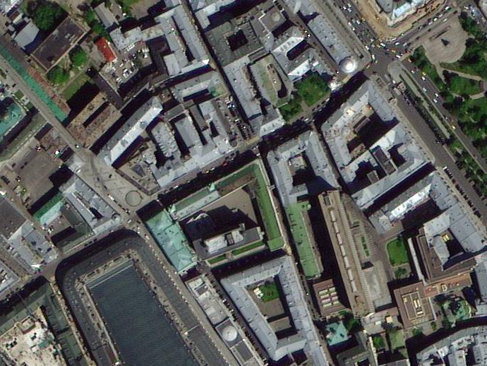
For 2016 and 2019, a constellation of 3 satellites TripleSat Constellation, with a spatial resolution of 0,8 m, almost covered 100 per cent of 50 countries from around the world with its spatial satellite images. We propose special conditions on the order of satellite images from TripleSat Constellation over large areas.
 An example of a satellite image from the TripleSat Constellation satellite with a spatial resolution of 0.8 m.
Table: Percentage coverage of 50 countries with satellite images from TripleSat Constellation
| Continent | Country |
Country Size (km2) |
Country Coverage Rate | Acquisition Time |
|---|---|---|---|---|
| Africa | Algeria | 2,320,000 | 97% | 2016-2019 |
| Botswana | 579,600 | 99% | 2016-2019 | |
| Faso | 274,400 | 100% | 2016-2019 | |
| Ghana | 239,800 | 90% | 2016-2019 | |
| Guinea | 245,900 | 95% | 2016-2019 | |
| Zambia | 754,100 | 95% | 2016-2019 | |
| Western Sahara | 267,200 | 97% | 2016-2019 | |
| Zimbabwe | 391,900 | 100% | 2016-2019 | |
| Mali | 1,256,000 | 100% | 2016-2019 | |
| Morocco | 406,700 | 98% | 2016-2019 | |
| Namibia | 826,400 | 99% | 2016-2019 | |
| Nigeria | 913,200 | 90% | 2016-2019 | |
| Senegal | 1,975,000 | 100% | 2016-2019 | |
| Sudan | 2,513,000 | 99% | 2016-2019 | |
| Central African | 622,900 | 97% | 2016-2019 | |
| Chad | 1,274,000 | 99% | 2016-2019 | |
| Ethiopia | 1,132,000 | 99% | 2016-2019 | |
|
South Africa |
1,222,000 | 100% | 2016-2019 | |
| America | Brazil | 8,518,000 | 90% | 2016-2019 |
| Mexico | 1,959,000 | 90% | 2016-2019 | |
| Paraguay | 400,300 | 97% | 2016-2019 | |
| USA | 9,297,000 | 87% | 2016-2019 | |
| Asia | Afghanistan | 641,500 | 99% | 2016-2019 |
| Iraq | 437,400 | 100% | 2016-2019 | |
| Yemen | 421,400 | 95% | 2016-2019 | |
| Kazakhstan | 2,715,000 | 100% | 2016-2019 | |
| Laos | 230,700 | 97% | 2016-2019 | |
| Myanmar | 669,400 | 97% | 2016-2019 | |
| Mongolia | 1,560,000 | 99% | 2016-2019 | |
| Oman | 309,000 | 99% | 2016-2019 | |
| Pakistan | 876,700 | 98% | 2016-2019 | |
| Saudi Arabia | 964,000 | 90% | 2016-2019 | |
| Syrian | 187,000 | 100% | 2016-2019 | |
| Thailand | 516,900 | 90% | 2016-2019 | |
| Turkmenistan | 488,900 | 100% | 2016-2019 | |
| Uzbekistan | 454,800 | 99% | 2016-2019 | |
| Japan | 373,400 | 97% | 2016-2019 | |
| Europe | Belarus | 206,700 | 95% | 2016-2019 |
| Bulgaria | 111,100 | 100% | 2016-2019 | |
| United Kingdom | 244,000 | 90% | 2016-2019 | |
| Germany | 356,000 | 98% | 2016-2019 | |
| Spain | 497,500 | 99% | 2016-2019 | |
| Italy | 301,100 | 97% | 2016-2019 | |
| Poland | 310,700 | 99% | 2016-2019 | |
| Romania | 237,400 | 99% | 2016-2019 | |
| Turkey | 780,500 | 100% | 2016-2019 | |
| Ukraine | 598,600 | 95% | 2016-2019 | |
| Finland | 334,600 | 90% | 2016-2019 | |
| France | 547,300 | 100% | 2016-2019 | |
| Oceania | Australia | 7,705,000 | 95% | 2016-2019 |
Satellite imagery can be used for the following purposes:
- mapping and updating of topographic and special maps as well as plans up to the scale of 1:10 000;
- monitoring for transport infrastructure construction, oil and gas production, change monitoring;
- updating of large scale land map for project development of general plans for perspective urban expansion, territorial planning schemes of municipal areas;
- agricultural land use inventory, a creation of land use planning;
- inventory and condition monitoring of transport, energy, information communications;
- monitoring of water bodies and hydro-technical constructions;
- ecological monitoring of environment status.
For calculating the cost and selection of the appropriate coverage of the interested area with TripleSat Constellation - 1,2,3 satellite imagery or alternative satellites, send technical specifications or coordinates on the following email: innoter@innoter.com.
We will be glad to answer all your questions by phone: +7 (495) 245-04-24
