Sat-Sun: Non-working days
Customer
Magnitogorsk city administration
Project's objective
Provision of activities for the development of urban planning documentation with topographic materials for the preparation of land for housing development in the framework of the municipal program "Housing in the city of Magnitogorsk" for 2016-2018.Work description
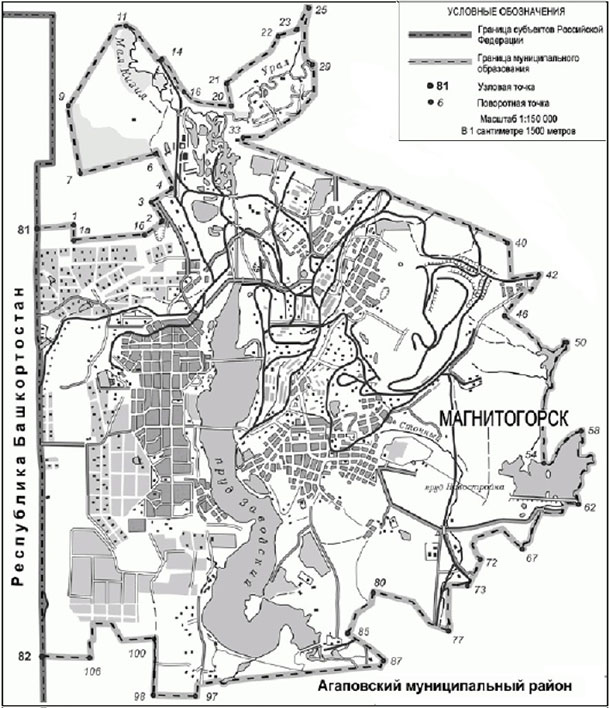
In accordance with the terms of the contract, Innoter LLC provided services for digital aerial photography and airborne laser scanning in order to create digital orthophotomaps of 1: 2000 scale and digital terrain model (DTM) for the development of urban planning documentation in the city of Magnitogorsk (395 sq. km) requested by the city’s architecture and urban planning department.

Borders of the AOI, Chelyabinsk region 395 sq. km.
The first stage was the implementation of digital aerial photography, airborne laser scanning in accordance with the requirements of the technical specifications. Aerial photographs with a sharp image without defects interfering with the interpretation of aerial photographs were selected. Color range: RGB. When carrying out ground support of aerial photography, at least one base station was used, in which two-frequency GNSS receivers of the geodesic class were used.
Planimetric-altitude basis for photogrammetric processing of aerial photographs were the points of the state geodetic network (SGN), aerial photography centers and ground identification marks. For the points of the SGN in accordance with the "Instructions for the protection of geodetic points" conducted a field survey.
The design of the marks was carried out in accordance with the "Instructions for surveying on a scale of 1: 5000, 1: 2000, 1: 1000, 1: 500" of 1982 and the "Instructions for photogrammetric work in creating digital topographic maps and plans" 2002 each identification was created in electronic form.
The second stage was the creation of digital orthophotomaps at a scale of 1: 2000 based on the resulting survey. To perform orthorectification of images from airborne laser scanning materials by classifying the points of reflection of the earth's surface, a DTM was created. Accuracy in height corresponded to the technical specification and the corresponding instructions for photogrammetric work. Basing on the obtained DTM, digital orthophotomaps of 1: 2000 scale were created.
The final stage of the work was the cutting of the final product – orthophotomaps and DTM – into rectangular sheets measuring 1x1 km on the ground. The borders of the sheets were the lines of the kilometer grid of the coordinate system MSK-74. In addition, a Technical Report on the work done was created, containing information about each type of work.
Results
As a result of the fulfillment by LLC Innoter of its obligations under the contract, the following materials were transferred to the customer upon completion of the provision of the service:- digital data on a hard disk containing aerial photography results, orthophotomaps of 1: 2000 scale, as well as a digital elevation model for the requested territory;
- technical report on the work performed.
Need for consultation?
Fill the form and we will contact you
