Sat-Sun: Non-working days
Customer
Gazprom Neft-Yamal LLCProject's objective
Delivery of a new space survey and creation of orthophotomaps within the framework of land surveying and update of cartographic material on the license areas of the customer.Work description
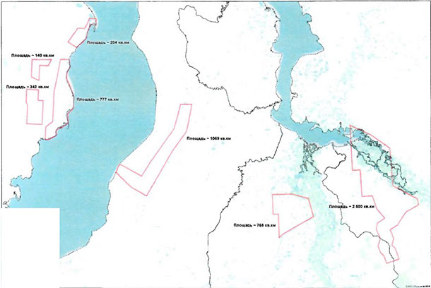
In accordance with the terms of the contract, Innoter LLC has made an order for a new high-resolution space survey (up to 0.5 m in nadir) on the territory of several license areas in the Tyumen region with a total area of 5800 sq. km.
The obtained satellite images corresponded to the requirements of the customer’s technical specification, namely:
-
multispectral shooting range
-
coordinate systems: MSC 89, SC 63, SC 95
-
permissible percentage of cloudiness per work area: 10%

The general scheme of license areas, 5800 sq. km.
The second stage of the work was to create a digital orthomosaic based on the obtained remote sensing materials on a scale of 1:10 000. The images were color-corrected and brought into nadir, stitched and released in a format compatible with MapInfo, AutoCAD and ArcGIS with a trapezoid breakdown into according to the coordinate systems used.
At the final stage, a layout of sheets for the work area and an explanatory note reflecting the methodology, technology and accuracy of the work performed were drawn up. In addition, at the request of the customer, “rude” orthoimages with a spatial resolution of 3-5 m were created.
Results
As a result of the fulfillment by LLC Innoter of its obligations under the contract, the following materials were transferred via FTP to the customer:
-
Digital orthomosaics in the framework of the “trapezoid” scale of 1:10000 in MSC-89;
-
Digital orthomosaics in the framework of the “trapezoid” scale of 1:10000 in SC-95;
-
Space images in natural color and in synthetic colors with near-IR channel;
-
“Rude” orthoimages with a spatial resolution of 3-5 m;
-
Map layout of sheets of space images;
-
Supporting documentation.
Need for consultation?
Fill the form and we will contact you
