Sat-Sun: Non-working days
Project's objective
For mapping of hydrothermally altered rocks associated with porphyry copper mineralization using the Sarcheshme deposit as an example, ASTER satellite images were used. Porphyry copper deposits, as a rule, are characterized by zones of hydrothermal changes.
Work description
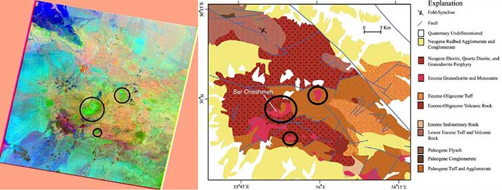
The work was carried out according to the ASTER photograph for July 15, 2007 with the processing level of 1T (with correction for the relief) in the VNIR and SWIR ranges. A radiometric calibration was performed for the image, followed by atmospheric correction using the IARR (Internal Average Relative Reflection) method. Then the VNIR and SWIR ranges were combined into a single composite with a resolution of 15 m.
To identify zones of hydrothermal changes, the following methods were used:
-
PCA (Principal Component Analysis) – principal component method;
-
MNF (Minimum Noise Fraction) – noise reduction;
-
Spectral indices.

Hydrothermally modified rocks on the RGB composite 1–3 MNF component (left) and a fragment of the geological map (right)
Results
The method for detecting hydrothermally modified rocks has been tested using PCA, spectral indices and MNF methods. The identified ranges of hydrothermal rocks are confirmed by a geological map. It is proved that remote sensing methods are effective for identifying porphyry copper deposits.
Need for consultation?
Fill the form and we will contact you
