Sat-Sun: Non-working days
Project's objective
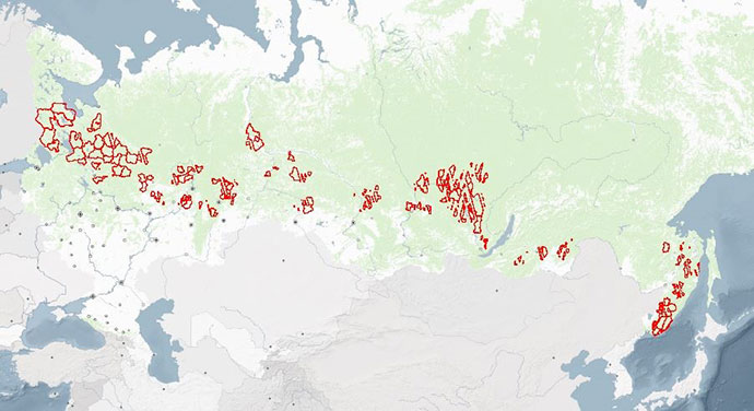
Informational provision of space imagery to the territory indicated by the customer in the technical specifications of forest areas with a total area of 51,446,046 hectares, as well as an examination to determine whether the satellite imagery materials transmitted to the customer meet the requirements of the technical specifications and regulatory legal acts.
Work description
Under the terms of the contract, Innoter LLC carried out the selection and ordering of archival data of remote sensing of the Earth on the territory of forestries received for the snowless period – from May 15 to September 30, 2015.
-
Images were ordered from various spacecraft, such as WorldView-2, GeoEye-1, QuickBird, Pleiades 1A / 1B, SPOT-6/7. The spatial resolution of the obtained materials of multispectral or panchromatic space imaging of the optical range, covering up to 60% of the territory of interest, was not more than 4 m at nadir; covering the remaining 40% - not more than 5 m.
-
The standard shooting mode is shooting in nadir.
-
Angle of sight 0-30°.
-
The range of angles of the sun is 40-70°.
-
The level of image processing included radiometric correction, geometric correction of systematic sensor errors, including panoramic distortions, distortions caused by the rotation and curvature of the Earth, fluctuations in the height of the satellite orbit.
-
The accuracy of the geo-referencing of the received images is no worse than 20 m.
-
Pictures taken before the beginning or after the end of the vegetation of forest vegetation, pictures with existing snow cover, pictures exceeding the maximum cloudiness were rejected and an acceptable replacement was chosen for them.
-
According to the results, the maximum cloudiness of images did not exceed 5% for the work object.

The layout of the objects of the state forest inventory works in terms of remote monitoring of forest use.
At the final stage of the work, the experts of Innoter LLC, who have certificates of experts in the field of evaluation of documentation and examination of materials obtained from aerospace photography, were examined to determine the quality of remote sensing materials transmitted to the customer. The examination was carried out basing on the internal regulations of Innoter LLC, considering the provisions of regulatory legal acts, including technical regulatory legal acts in the field of geodetic and cartographic activities. As a result of this examination, the correspondence of the materials of the space survey transmitted to the customer was established according to the following parameters:
-
full coverage of a given territory;
-
spectral range of shooting;
-
spatial resolution;
-
the value of the spatial resolution (GSD), corresponding to the technical characteristics of the satellite (must be no more than the allowable spatial resolution of the survey);
-
date, time and season (period) of shooting;
-
the accuracy of the geodetic reference (in the presence of control points);
-
model of satellite and camera;
-
image processing level: radiometric correction, color synthesis, geometric correction of systematic sensor errors, including panoramic distortions, distortions caused by the rotation and curvature of the Earth, fluctuations in the height of the satellite orbit;
-
angle of sight;
-
angle of height of the sun above the horizon;
-
percentage of cloudness;
-
average nadir deviation angle;
-
composition and accuracy of metadata;
-
image integrity (no “broken” pixels – missing parts).
Results
The results of the examination were issued in the form of an expert opinion, basing on which all the data corresponded to the specified parameters.
Need for consultation?
Fill the form and we will contact you
