of geospatial solutions
Sat-Sun: Non-working days
Project's objective
Creation of a Digital Urban Model (3D) for large cities with a population of over 100,000 people, administrative and industrial centers, cities with a high penetration of state-of-the-art telecommunication networks, and high levels of new construction development.
Required components of the digital 3D model:
- Digital Surface Model;
- Digital Terrain Model;
- Clutter Model;
- Vector Model;
- Obstacle Height Model (buildings, vegetation, engineering structures).
Accuracy parameters for 3D models
|
Parameter |
Resolution 2m |
Resolution 5m |
|
Resolution (cell size) |
2 meters |
5 meters |
|
Altimetric Accuracy (z) |
3 meters |
5 meters |
|
Planimetric Accuracy (x, y) |
4 meters |
6 meters |
|
Building Height Accuracy (h) |
4 meters |
5 meters |
|
Minimum Mappable Building Object |
16 sq. meters |
25 sq. meters |
|
Minimum Recognizable Building Height |
3 meters |
5 meters |
|
Vegetation |
As segmented polygons with individual heights |
As polygons with averaged height |
|
Minimum Mappable Vegetation Object |
25 sq. meters |
50 sq. meters |
Work description
Types of work performed in creating a digital 3D model:
- Selection and ordering of satellite images that meet the technical specifications (TS), stereophotogrammetric processing of satellite images, and the creation of orthophotoplans;
- Selection, analysis, and acquisition of initial vector data in the area of interest, archival topographic maps and plans in raster and vector formats;
- Creation of a Digital Terrain Model;
- Creation of a Digital Surface Model;
- Creation of an Obstacle Height Model;
- Creation of a Vector Model;
- Creation of a Clutter Model.
1. According to the TS, to create a 3D digital model, it was necessary to use a digital orthophotoplan created from current Earth remote sensing materials (ERS) with a resolution of 0.5 meters. Satellite images from KOMPSAT with spatial resolution of 0.5 meters for the panchromatic channel and 2.0 meters for the multispectral channel were selected as the source data.
As a result of photogrammetric processing, an orthophotoplan of the city was obtained, radiometric color correction was performed, colors were balanced and adjusted to natural tones, and color equalization was carried out for each image individually.
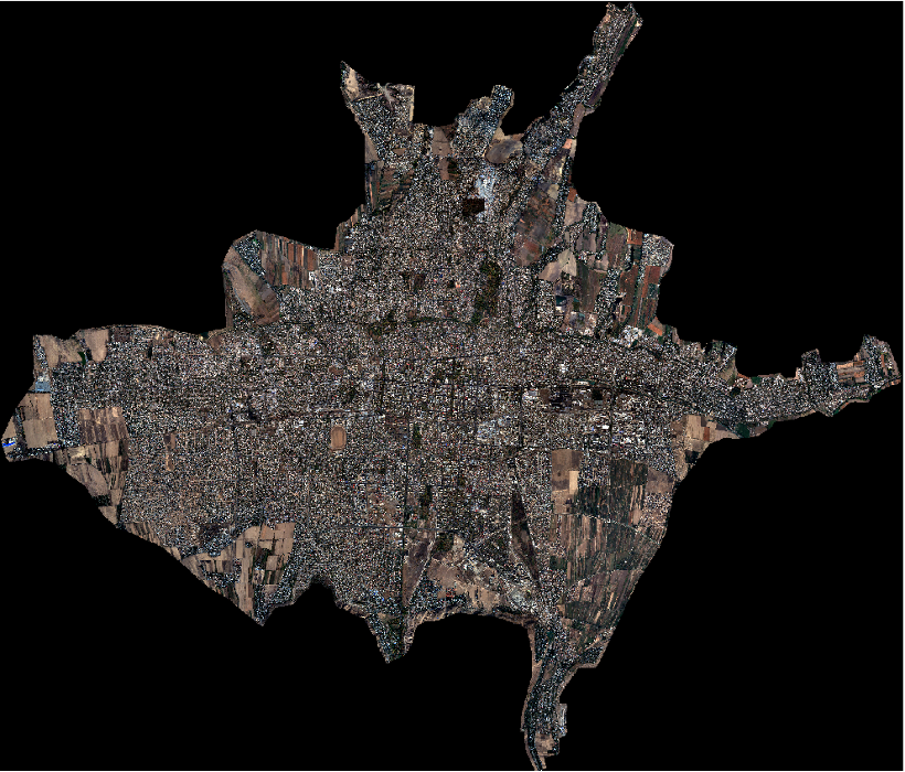
Figure 1. Original satellite images
2. The selection, analysis, and acquisition of initial vector data and archival topographic maps at scales of 1:10,000 to 1:25,000 in raster and vector formats included the systematization of source material, checking data completeness, and recording and storage. All source materials used for the work undergo entry control. Vector data, topographic maps in raster and vector formats used for creating the digital model, serve as the basis for forming the initial set of vector layers, which are further updated and corrected according to the digital orthophotoplan.
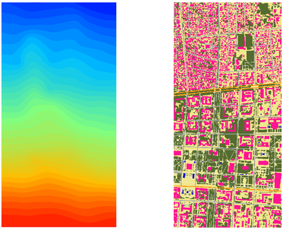
3. The creation of a Digital Terrain Model and a Digital Surface Model was carried out by photogrammetric processing of satellite images with a resolution of 0.5 meters. The Obstacle Height Model for the city was determined by calculating the difference between the Digital Surface Model (DSM, representing the tops of trees, buildings, and other objects) and the Digital Terrain Model (DTM, representing ground level) and refined using stereo images in automatic or semi-automatic mode using direct and indirect image features.
|
Figure 2. Fragment of the Digital Terrain Model |
|
Figure 3. Fragment of the Digital Surface Model |
4. The Obstacle Height Model for the city was determined by calculating the difference between the Digital Terrain Model and the Digital Surface Model and refined using single and stereo images by counting the number of floors visible on the sloping sides of buildings and by measuring the length of shadows of buildings and structures on the ground.
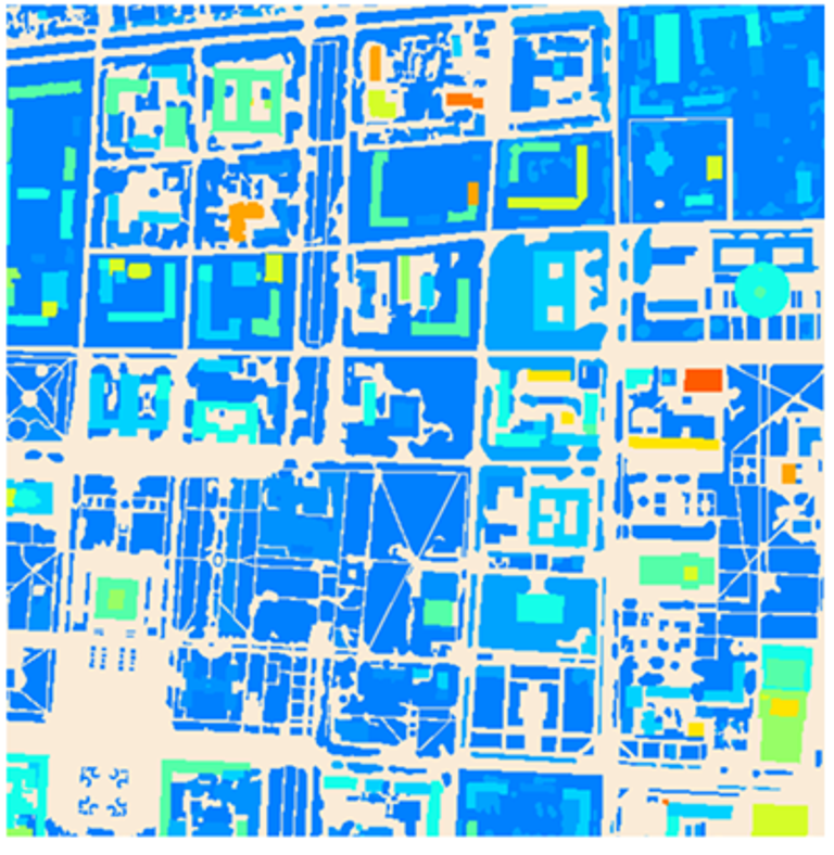 Figure 4. Fragment of the Obstacle Height Model
5. Prepared vector layers were supplemented with information about the type of objects and were formed into a "Vector Model" dataset in *.tab format.
The Vector Model includes the following objects:
- Linear Objects - Shorelines of rivers, lakes, seas, rivers less than 10 meters wide. Roads, administrative boundaries, airport areas;
- Building footprints with individual heights;
- Text Labels - Names of administrative regions, districts, rural areas, populated places, roads, water bodies, rivers.
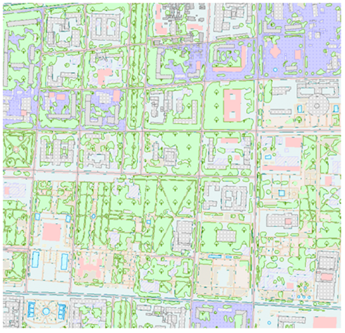 Figure 5. Fragment of the Vector Model
6. To create the "Clutter Model" product, vector layers were formatted as required and filled with the necessary semantic information in accordance with a list of 20 clutter classes for the 3D model.
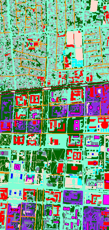 Figure 6. Fragment of the Clutter Model
Results
The set of materials provided to the Customer includes:
- Orthophotoplan;
- Digital Terrain Model;
- Digital Surface Model;
- Obstacle Height Model;
- Vector Model;
- Clutter Model.
Digital models are prepared based on UTM Projection, WGS-84 Ellipsoid, Baltic Height System, and are fully compatible with the Mentum Planet planning tool. They can also be provided in formats compatible with ASSET, ATOLL, and Mapinfo software.
The mentioned materials are used by the Customer to address the following tasks:
- Creating a digital twin of the city;
- Spatial analysis of existing networks and the environment;
- Spatial analysis and modeling for planning new networks;
- Selecting sites with corresponding calculations for cellular antennas, PCS radio ports, fiber nodes, repeaters;
- Determining the optimal cable laying route considering central road and railway lines, as well as various underground communications;
- Determining the optimal location of radio relay lines considering surface profiles;
- Defining optical visibility from antenna locations;
- Modeling radio wave propagation and analyzing their coverage areas;
- Obtaining geographically referenced measurements of electromagnetic field values (GIS+GPS) and analyzing them.
Need for consultation?
Fill the form and we will contact you
Sat-Sun: Non-working days