of geospatial solutions
Sat-Sun: Non-working days
Customer
Mobile operator
Project's objective
Creation of a digital terrain model (regional 2D model) for the Leningrad region with actively developing infrastructure for assessing the terrain, orienting on the terrain, performing design and survey work, ensuring the construction and reconstruction of the infrastructure of telecommunication networks, determining the coordinates of objects, calculating routes, calculating radio network coverage, displaying network elements, as well as for solving other tasks in the interests of the activities of the Cellular Operator.Completed work
Work description
Required composition of the DTM
The Leningrad Region requires the creation of a FMC with the following composition:
- regional digital vector 2D model;
- regional digital clutter 2D model;
- regional digital 2D relief model;
- regional digital 2D obstacle height model.
DTM Accuracy Options
| Naming errors | Values of mean errors in the position of DTM points in meters |
|---|---|
|
In the planned position of buildings and images of clear contours |
50 |
|
In the planned position of the contours of the vegetation cover and soils (values for mountainous and desert regions are given in brackets) |
70 (до 100) |
|
In the level position of points in flat areas |
5 |
|
In the level position of points in rugged, hilly, sandy areas |
7 |
|
In the level position of points in low-mountain and mid-mountain territories |
10 |
|
In the level position of points in high-mountain areas |
20 |
Creation of the DTM for the Leningrad region
- To create the DTM, the cartographic materials at a scale of 1:100 000 available at the Center for Geodesy, Cartography and Spatial Data, Rosreestr materials and satellite imagery materials obtained from foreign spacecraft with a resolution of 5 m were used as the initial cartographic material. Based on the obtained remote sensing materials, ortho photomaps were created in accordance with the requirements specified in the table below. The materials used to create the DSM ensured the necessary accuracy, completeness and reliability of drawing terrain objects.
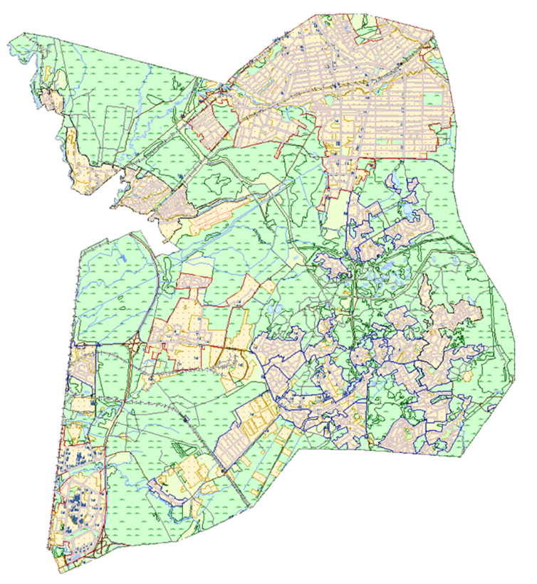
- The regional digital vector 2D model was created on the basis of the available vector data and topographic maps in raster and vector form to form the initial set of vector layers, which were further updated and corrected according to the digital ortho mosaic.
Regional digital vector 2D model
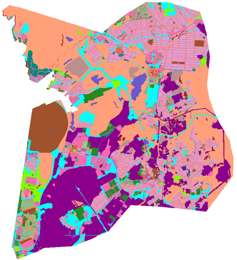
- Regional digital clutter 2D model was created on the basis of vector2D models, brought to the required form and filled with the necessary semantic information in accordance with a description and full composition of 32 morphological types of objects specified by the Customer.
Regional digital clutter 2D model
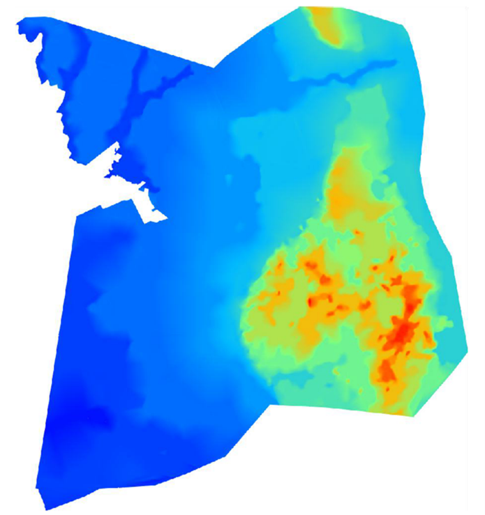
- A regional digital 2D relief model was created using a publicly available matrix of heights with an accuracy of 5 m. Based on this matrix, a relief was created with a contour section of 5 meters. In order to more accurately build the relief using the DEM, vector objects of hydrography were used, according to which the obtained contour lines were checked and coordinated with the objects of hydrography.
Regional digital 2D elevation model
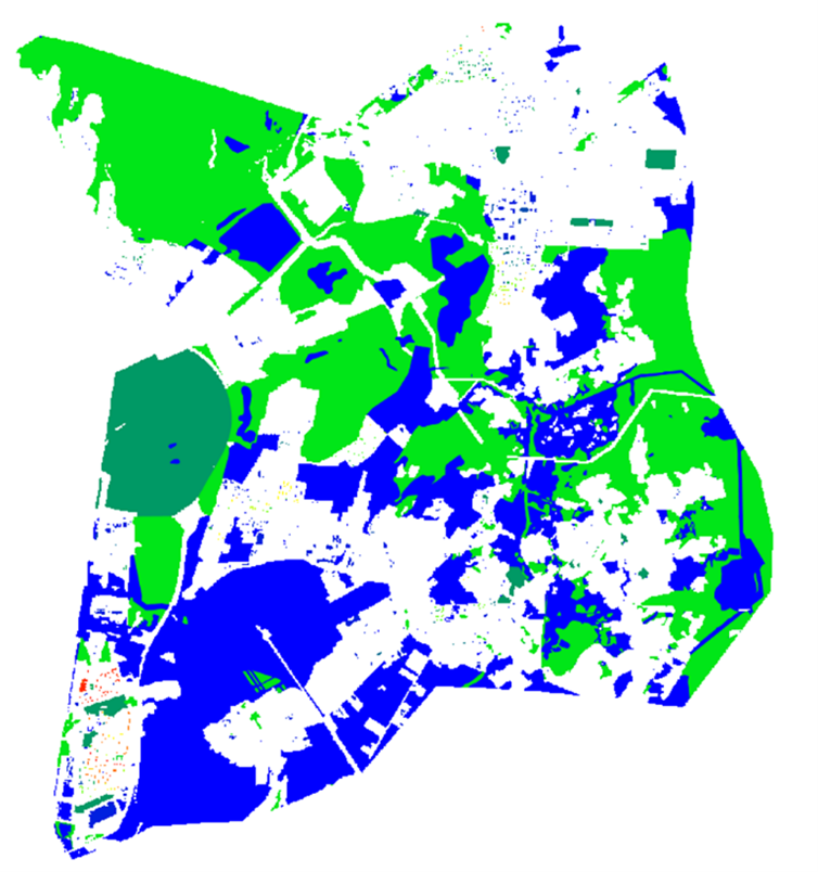
- A regional digital 2D model of obstacle heights is presented as part of morphological types (vegetation, soils and blocks), each point of the matrix is equal to the value of the height of the object.
Regional digital 2D model of obstacle heights
Contents of delivery DTM to the Leningrad region:
- DTM in the format of the Asset Enterprise radio network planning system (version 9.0 or later).
- DTM adapted to the planning system for the mobile telephone network of the PAK "ONEGA RPLS" standard.
- Digital vector base map in GIS "MapInfo" format.
- Level surface matrix in the form of grids MapInfo Vertical Mapper GRD (Grid) and GRC (Classified Grid) formats.
- DTM passport, which includes information about the territory of the map, the relative position of the fragments contained in separate data files and the types of objects contained in the supplied DTM, scale, projection, coordinate system, sheet corner coordinates, etc.
- Technical report, which contains information about the work performed under the contract, with exhaustive completeness to characterize the methods, the quality of the work performed and all the features of the technology for their implementation.
Results
Digital Terrain Models (DTM) for the Leningrad Region are used by the Customer to solve the following tasks:
- Terrain assessments.
- Orientation on the ground.
- Execution of design and survey works.
- Ensuring the construction and reconstruction of the infrastructure of telecommunication networks.
- Determining the coordinates of objects.
- Calculation of routes.
- Calculation of radio network coverages.
- Display of network elements.
Need for consultation?
Fill the form and we will contact you
Sat-Sun: Non-working days