Contact

Delivery of Alos stereo imagery and creation digital elevation model

01

About the project

Creation of a Digital Relief Model (DEM) based on the materials of space stereoscopic survey of the Alos spacecraft, with an area of ​​more than 800 sq. km.

Industry Land use and territory management
End date 10/31/2018
02

Project goal

Creation of a Digital Relief Model (DEM) on nomenclature sheets in Photomod software

03

Completed works

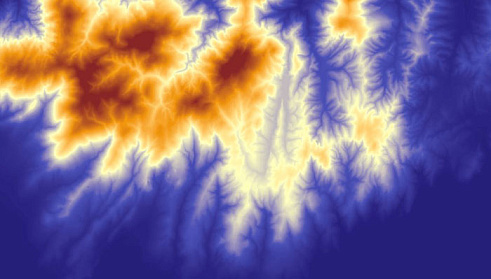
The creation of the Digital Relief Model (DEM) on the nomenclature sheets required by the customer was carried out in Photomod software using shutter glasses and monitors with an image refresh rate of at least 120 Hz based on stereo photography from the «Alos» spacecraft, Prism mode, spatial resolution 2.5 m


Example of a digital elevation model DEM
Example of digital elevation model DEM
04

Result

The DEM was delivered in TIFF format in UK 1942 (zone 5) with RMS corresponding to the guidelines for creating topographic plans at a scale of 1: 50,000. The customer provided points of the KPVO in the UK 1942 as reference points.

Need satellite imagery or help choosing the right data?

Describe your task, area of interest, and desired outcome. We will check data availability, assess new acquisition options, and propose the optimal solution in terms of timelines, cost, and quality.
clients who trust us
25+ years in the geodata market
Request a call back
Back to page top
Мы используем Яндекс.Метрика и собственные Сookies для обеспечения наилучшего опыта работы на нашем сайте, персонализации сайта для наших пользователей и аналитики. Продолжая использовать сайт вы соглашаетесь с условиями Пользовательского соглашения.