of geospatial solutions
Sat-Sun: Non-working days
Project's objective
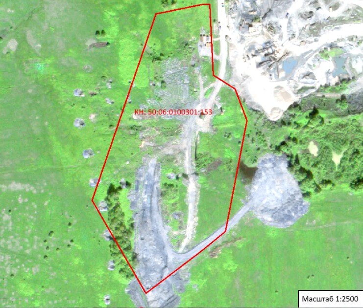
Visual interpretation of the satellite image, determination of the presence of violations of the integrity of the vegetation and soil cover at the site as of June 11, 2011.Completed work
Work description
Investigation of WorldView-2 satellite images obtained on June 11, 2011 in connection with their suitability for detailed interpretation by the resolution parameter (Ground Sample Distance), not exceeding 0.5 m in one pixel. For examination, Innoter LLC acquired a digital space image obtained by the WorldView-2 satellite, which is the commercial property of the American company MAXAR. Date of filming - June 11, 2011. The spatial resolution of the image is 50 cm. Before working with the "WorldView-2" image, it was orthorectified.
Significant disturbances in the soil and vegetation cover were found at the site. Wasteland without soil cover reaches the southern border of the site, its area is approximately 25,500 sq. M. There are two roads on the site, the first runs along the center of the site, the second is located along the southeastern border of the site, passing to another wasteland that goes beyond the boundaries of the site. Both on the territory of the site and outside of it there are disturbances of vegetation and soil cover in the form of dug holes with an average area of about 180 sq.m. There is a forest area near the south-western border, its area is approximately 4500 sq. M. On the plot there is one building with an area of approximately 34 sq.m.
Results
Violations of the integrity of the vegetation and soil cover were revealed as of June 11, 2011.The nature and extent of violations of the integrity of the vegetation and soil cover on the site with the cadastral number of the customer have been established:
- the nature of violations of the integrity of the vegetation cover is of an anthropogenic nature (the wasteland has a clear outline with straight lines and even corners);
- the area without vegetation is 25,500 sq.m., the forest area is 4500 sq.m.
Need for consultation?
Fill the form and we will contact you
Sat-Sun: Non-working days