Sat-Sun: Non-working days
Customer
Private agricultural companyProject's objective
The co-owner of the Company, which owns agricultural land, filed a lawsuit against the Company's management for causing damage to the Company. Specifically, they accused the Company of stealing winter wheat crops. The opposing party in court claimed that during the relevant period, the fields were not sown with wheat; instead, they were planted with short-cycle cover crops, resulting in the cutting and harvesting of hay rather than a crop. They argued that there were no grounds for compensation, and the Company's management did not cause any damage. The absence of a winter wheat crop was also confirmed by witness statements.
In search of the truth, the plaintiff's lawyers sought legal assistance from GEO Innoter to use satellite imagery to prove the existence of a winter wheat crop on the farm during the relevant period. The assessment of the subject of the dispute, whether there was a crop or not, was estimated to be around 30+ million rubles.

Task
Identification of the state of the winter wheat crop using the Normalized Difference Vegetation Index (NDVI) based on satellite imagery.
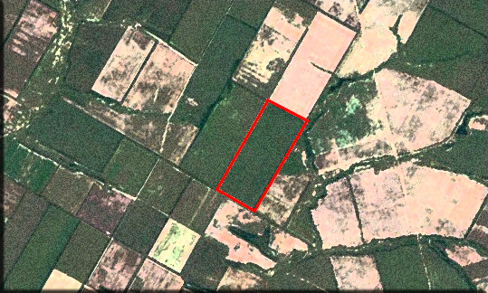
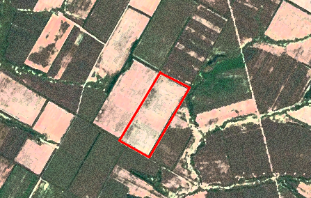
GEO Innoter specialists selected 12 (twelve) archive satellite images from Sentinel-2 (for the fall of 2019 and spring, summer, and 2020) and a high-resolution satellite image from Superview (China) for the summer of 2020, confirming the technical feasibility of providing the service.
The following questions were prepared and agreed upon with the expert:
- Locate the land plot;
- Conduct a comparative analysis of changes in the satellite images on the specified dates for the areas under consideration:
- Presence of crop residues or stubble;
- Presence of winter wheat sowings;
- Presence of winter wheat seedlings;
- Confirmation of crop harvesting.
Work description
The main tool of this expertise is the Vegetation Index (NDVI). It is an indicator that can reveal the presence of plants and the period of vegetation they are in. Obtaining the index is based on interactions with various spectral ranges of Earth remote sensing data. Plants absorb the red spectrum with their green mass and reflect near-infrared. The resolution of the satellite images was 10 meters per pixel, and the wheat field covered an area of 620 hectares. The scale of the images allowed us to observe the key stages of plant development.
When using higher-resolution imagery, it is possible to determine the presence of weeds or diseases, assess the germination and growth of plants, and even forecast the productivity of crop rotation fields.
The primary goal was to monitor the dynamics of crop growth and development and establish the timing of harvesting.
We obtained satellite images for March-April 2020 and June 2020. Processing of satellite imagery and measurement of the vegetation index were performed using several software programs. Preliminary operations were carried out in QGIS (version 3.24.2) and ENVI software (Harris).
Image preparation included the following tasks:
- Locating and extracting the required area from the entire area;
- Merging the panchromatic and multispectral channels to obtain a high-quality color image;
- Atmospheric and radiometric correction;
- Geocoding, or image registration to the WGS 84 global coordinate system (resulting in each pixel on the image corresponding to specific points on the ground).
This level of processing is necessary for quantitative and qualitative analysis based on NDVI. It is important to understand that atmospheric correction helps reduce errors when assessing the vegetative state of crops in the fields.
NDVI measurement was conducted using ArcGIS software (ESRI).
NDVI values in the images for August and September clearly showed that there was no vegetation in the fields.
NDVI values in the images for October indicated the presence of vegetation in the fields, with a high level of vegetation on each field.
During the spring period, it was established that the fields had wheat seedlings in the tillering phase, rather than crop residues or stubble (which are remnants of plants that improve soil fertility). At the end of May, the analysis of satellite images showed a high level of vegetative activity, indicating that the wheat was in the shooting and heading stage.

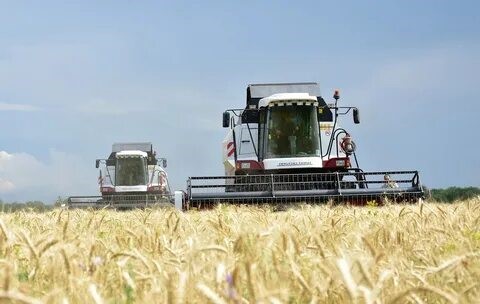
Satellite images for early June 2020 revealed the harvesting of crops during that period. The use of high-resolution images allowed us to decipher traces of agricultural machinery in the fields during the harvest.

Thanks to the spectral analysis of satellite images, GEO INNOTER specialists deciphered the period of winter wheat sowing, germination, growth, ripening, and harvest.
Results
The customer successfully proved the presence of a winter wheat crop and its harvesting, confirming property damage amounting to over 30 million rubles.
This type of evidence has 100% accuracy and is less financially and labor-intensive compared to other forms of expertise. This method of data description allows for the analysis of events of almost any age and has a short execution period, typically around two to four weeks.
Thanks to our specialists, the customer obtained legally valid expertise within a short timeframe and at minimal cost.
Key Success Factor
The main success factors of our legal practice include having a large number of highly qualified specialists with relevant higher education, the use of high-quality Earth remote sensing data, and the continuous improvement of data processing methods and the application of new space technologies.

Expert Opinion
Confirmation of the quality of the performed expertise and its effectiveness in resolving the legal dispute is evidenced by the fact that our expert was summoned by the investigator just one day (!) after our photo-technical expertise was officially handed over to the investigator by the lawyer. Instead of refusing to initiate a criminal case, which seemed likely, the investigator acknowledged the presence of the crop, which the Defendant denied but was supported by witness testimonies. The investigator also recognized the theft of the crop. Involving the defense side - GEO INNOTER lawyers, who possess spectral deciphering technology of satellite imagery, their own laboratory for Earth observation imagery analysis, certified specialists, and experts, allowed to turn the course of the case!
Need for consultation?
Fill the form and we will contact you
