of geospatial solutions
Sat-Sun: Non-working days
Customer
Investigation Department of the Ministry of Internal Affairs of the Russian Federation
Project's objective
The purpose of the examination is to determine the geodynamic changes of terrain objects. Changes occurred during a certain period, if so, which specific objects were changed (buildings, trees, shrubs, topsoil, etc.).
Completed work
Work description
The examination was carried out in two areas located on the right bank of the Uryush river, the Republic of Bashkortostan. For the research materials of space imagery obtained at different times were used.
Were selected images obtained by the American space shooting systems QuickBird-2, WorldView-1, WorldView-2 and Ikonos, with a resolution of 0.5 - 0.9 m.
Multi-temporal space images were selected based on the date of work performed at the sites - November 2010. In principle, 3 images were selected by November 2010 (obtained in 2003-07-24, 2009-06-15, 2010-07-25) and after that date (received in 2011-06-21, 2012-03-02, 2013-03-29).
1) For the first district required to prove the appearance of real estate.
2) In the second district, it was necessary to obtain documentary evidence of the work performed, which was deforestation, cutting of shrubs and light forest along the roads.
Results
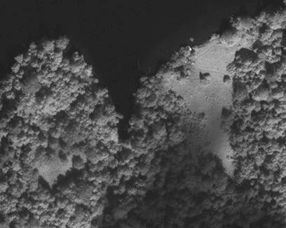
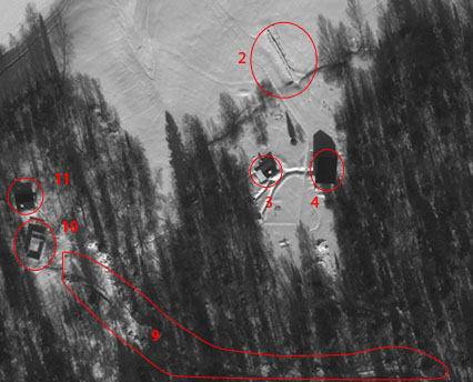
1) As a result of a comprehensive analysis of space images, a conclusion was made about the gradual emergence of objects of anthropogenic origin. (In Figure 1–2009, in Figure 2 – 2013).
2) As a result of the analysis of the materials, experts concluded that new objects and a new forest road appeared. Decreases of woody vegetation (felling) at the borders of roads were not found.
Need for consultation?
Fill the form and we will contact you
Sat-Sun: Non-working days