Sat-Sun: Non-working days
Customer
The Customer has a licensee of an oil and gas condensate field located in the Yamal-Nenets Autonomous Okrug of the Russian Federation approached GEO INNOTER LLC with the need to carry out a project for carrying out Interferometric processing of Radar Space Images being develop on the territory of the field.Results
Project goals:
- Monitoring of displacements of the earth's surface in accordance with the requirements of the legislation of the Russian Federation.
- Determining the impact of field development on the deformation of the earth's surface.
- Identification of hazardous geodynamic areas to ensure industrial safety, protection of subsoil, buildings and structures from the harmful effects of mining.
Requirements of the Customer to the Contractor:
- Fulfillment of the whole complex of works on “a turnkey basis”.
- Having relevant experience.
- Availability of qualified personnel.
- We would like to note that in order to perform the work, it was necessary to have a license to work with materials, which constitutes a state secret. LLC "GEO INNOTER" has this license (link to the page of licenses).
Satellite images used:
There are to the limited budget it was decide to use free space radar images by the Sentinel-1A/B satellite.
Initial materials provided by the Customer:
Geodynamic polygon projects.
Additional source materials provided by the Customer at the request of GEO INNOTER LLC:
- Contours of the license area and field.
- Well pad location.
- Discontinuity map (surface projection).
- Information on withdrawals and injections for the previous 5 years with distribution by pads / wells.
Requirements for the final result:
Final report containing :
- Building a digital terrain model for the field.
- Construction of schematic maps (isolines) of vertical displacements for the field.
- Identification of zones of geodynamic risk, conclusions and recommendations.
In the course of the work, the following stages were implemented:
- We analyzed 115 radar frames (the last 5 years) the Sentinel-1A/B satellite received from the same orbit. The full set of available images, a number of images were exclude during processing, on which the presence and state of natural and climatic factors do not allow reliable measurements (presence of snow cover, thunderstorms, ionospheric activity at the time of the survey). Suitable for further use 37 shots.
- The digital terrain model of the field is interferometric create of a pair radar images the Sentinel-1B satellite. Digital elevation model of the European Space Agency Copernicus DEM GLO-30 was use to improve the accuracy of the obtained digital terrain model. The declared error of height is no more than 3 m (for 95% of points).
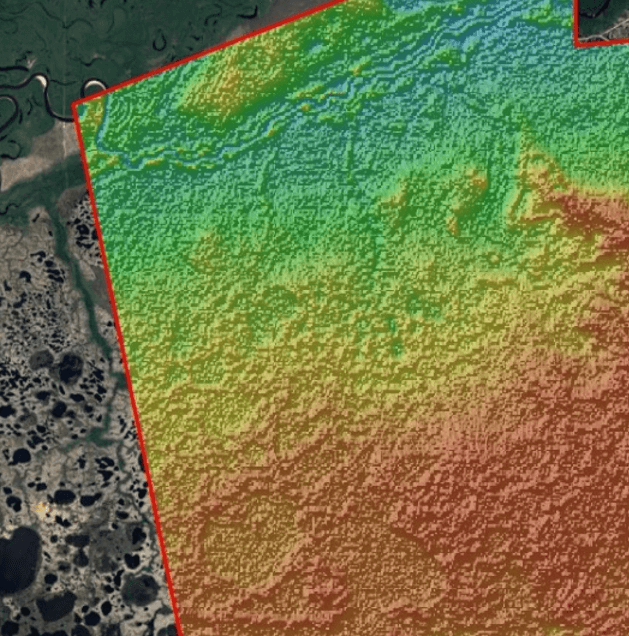
DSM within the boundaries of the licensed area (fragment).
Interferometric processing of the obtained series of radar images was perform using the method of permanent scatterers (or permanent reflectors) - from the English persistent scatterers (PS).
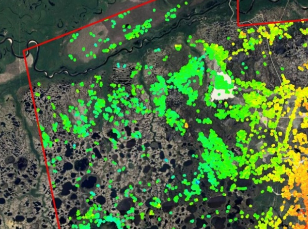
Distribution of permanent scatterers on the territory of the deposit (fragment)
- 4. Using the results of interferometric processing, a map of the average annual displacement velocities was compiled:
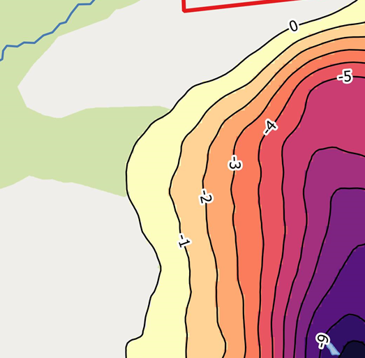
Map of average annual displacement rates (fragment)
- The vertical displacements measured by the high-precision leveling method are compared with the displacements towards the satellite ( LOS ) obtained by the radar interferometry method.
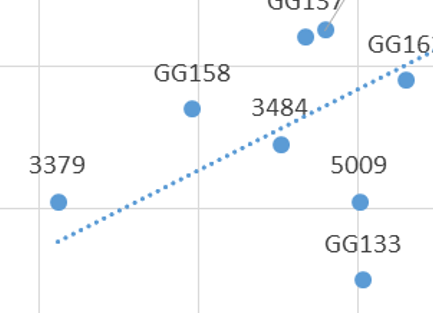
Cross craftt, along the horizontal axis of which are the values of displacements in the direction to the satellite (interferometry method), along the vertical axis are the values of vertical displacements at the same points (leveling method). Fragment.
- After obtaining the vertical displacements of the earth's surface, we proceeded to the calculation of deformations.
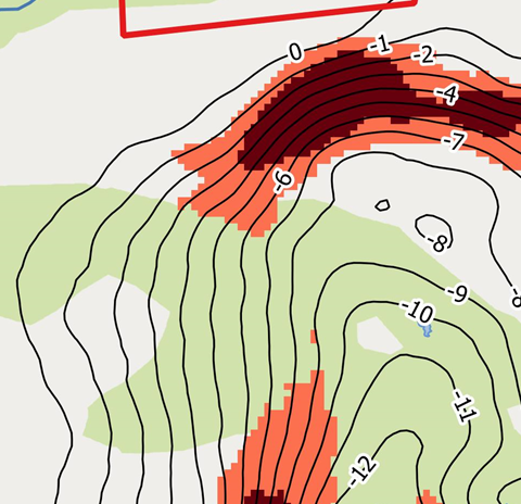
Average annual slopes at the field (fragment)
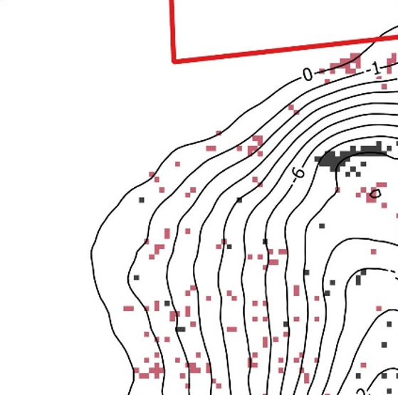
Average annual curvature of the surface of the displacement trough in the field (fragment).
- An assessment was made of potential geodynamic risks after calculating quantitative estimates of the parameters of deformations the earth's surface.
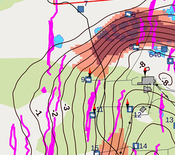
Map of geodynamic hazards (fragment)
- Made general conclusions and made relevant recommendations.
In this case, there are no observed geodynamic hazards in the license area. But for a number of related reasons, it is recommended to continue annual observations at the geodynamic test site using satellite radar interferometry using the method of constant reflectors, as well as to carry out leveling of the II accuracy class using the existing network of geodetic points as a verification method.
- Conducted an analysis of the nature of the relationship between hydrocarbon production and subsidence of the earth's surface .
The revealed relationship between subsidence of the earth's surface and the amount of extracted fluid suggests that displacements occur in the sedimentary cover in the developed reservoirs and that the cause of these subsidences is mainly the economic activity of the producing company.
- We handed over the work to the Customer without a single comment.
Need for consultation?
Fill the form and we will contact you
