of geospatial solutions
Sat-Sun: Non-working days
Customer
Oil and gas companyProject's objective
Source Data:
Deciphering aerospace images plays an important role in organizing geotechnical monitoring of main pipelines. Main pipelines are complex technical systems, so a thorough development of the decryption technology for infrastructure elements allows for the effective processing of remote sensing materials to support the operation of main oil pipelines, including monitoring tasks for engineering systems in complex natural and climatic conditions. Since the main task was to analyze various remote sensing materials to meet the production needs of oil and gas companies, satellite images with resolutions of 1.5 m and 0.5 m and UAV (Unmanned Aerial Vehicle) materials with a resolution of 0.1 m were selected. Vector data on the location of infrastructure objects were also provided by the customer.
Work Stages:
Stage 1: Preliminary material processing. Initially, primary processing of the survey materials was carried out, including radiometric, geometric, and atmospheric corrections. To improve the spatial alignment of the images, orthorectification was performed using reference points and the AW3D 30m digital elevation model. Color correction was also applied to enhance the interpretability of the images. As a result, orthophotoplans with a standard deviation of no more than 2 meters were obtained.
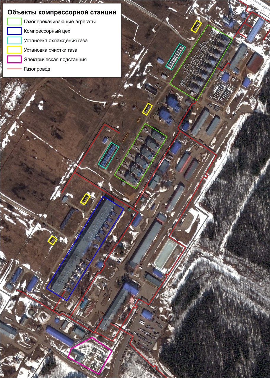
Stage 2: Deciphering terrain objects. The technological scheme for visually deciphering the infrastructure objects of main pipelines from high and very high-resolution satellite images involves recognizing objects of the natural and technical environment and then graphically highlighting them in the image. The informativeness largely depends on the spatial resolution of the images. An analysis of the feasibility of deciphering various objects in images with different spatial resolutions was conducted at this stage. Scanex Image Processor software was used in this phase.
Stage 3: Comparison of decryption results. After the completion of Stage 2, a comparative analysis of the deciphering capabilities of the oil and gas infrastructure objects was conducted. The main part of the report consisted of a list of objects recognizable in aerospace images with different spatial resolutions. The work on deciphering aerial survey materials showed that aerial images with a resolution of over 0.1 m/pixel allow deciphering the composition of objects in accordance with the requirements for 1:500 scale topographic plans. Aerial images with a resolution of 0.5 m/pixel, when accompanied by operational documentation, provide the ability to decipher the composition of objects in accordance with the requirements for 1:2000 scale topographic plans. Images from space with a resolution of 0.3 m/pixel make the recognition of main pipeline infrastructure objects more certain. In cases where the informativeness of the obtained schematics is insufficient and some objects or their characteristics cannot be identified, such as underground utilities, vegetation types, building purposes, etc., this data can be obtained during on-site terrain surveys and selective instrumental topographic surveys of the corresponding scale. Aerial images with a spatial resolution of 1.5 m/pixel can also be used for solving production tasks, such as creating simplified spatial data maps, which, nevertheless, can be extremely useful for populating corporate geoinformation systems and geoprotals. Currently, it is advisable to use materials from aerial surveying systems with high and medium spatial resolutions, as well as UAV and VLS (Very Low-Level Satellite) materials, in combination with height data obtained through precise leveling during geotechnical monitoring for populating corporate GIS.
Completed work
Work description
| Resolution of RS Data | Resolution | PD Class | ||
| 1.5 m/pixel | 0.5 m/pixel | 0.1 m/pixel | ||
| Data with a resolution of 1.5 m/pixel and larger are suitable for deciphering the listed objects. | Data with a resolution of 0.5 m/pixel and larger are suitable for deciphering the listed objects. | Data with a resolution of 0.1 m/pixel and larger are suitable for deciphering the listed objects. | <1.5 m/pixel | Sites (NPS, LPDS, UZA, SOD CP, etc.) |
| <1.5 m/pixel | Sites (schematic outline) | |||
| <1.5 m/pixel | Tower and mast structures | |||
| <1.5 m/pixel | Truss poles | |||
| <1.5 m/pixel | Protective and anti-erosion embankments | |||
| <1.5 m/pixel | Buildings | |||
| <1.5 m/pixel | Bridges | |||
| <1.5 m/pixel | Road and street axes | |||
| <1.5 m/pixel | Technological estacade axes | |||
| <1.5 m/pixel | Along-road passage axes | |||
| <1.5 m/pixel | MT technical corridors | |||
| <1.5 m/pixel | Overhead power line crossings | |||
| <1.5 m/pixel | Along-road passage crossings | |||
| <1.5 m/pixel | Hydrographic object crossings | |||
| <1.5 m/pixel | Large vertical cylindrical reservoirs | |||
| <1.5 m/pixel | Large structures | |||
| <1.5 m/pixel | Technological equipment (SOD CP, etc.) | |||
| <1.5 m/pixel | Technological equipment (outlines) | |||
| Data with a resolution of 1.5 m/pixel are not suitable for confident deciphering of the listed objects. | <0.5 m/pixel | Venturi tees | ||
| <0.5 m/pixel | Top/bottom platform fill | |||
| <0.5 m/pixel | Lightning rods | |||
| <0.5 m/pixel | Large-diameter valves | |||
| <0.5 m/pixel | Protective cases | |||
| <0.5 m/pixel | Pressure tapping pits | |||
| <0.5 m/pixel | Lighting masts | |||
| <0.5 m/pixel | Fences | |||
| <0.5 m/pixel | Power line supports (poles) | |||
| <0.5 m/pixel | MT axes | |||
| <0.5 m/pixel | Pedestrian pathway axes | |||
| <0.5 m/pixel | Service platforms | |||
| <0.5 m/pixel | Coverings | |||
| <0.5 m/pixel | Equipped MT crossings | |||
| <0.5 m/pixel | Small rectangular reservoirs | |||
| <0.5 m/pixel | Technological estacades | |||
| <0.5 m/pixel | Technological equipment (structures) | |||
| Data with resolutions of 0.5 and 1.5 m/pixel are not suitable for confident deciphering of the listed objects. | <0.1 m/pixel | Anchor blocks | ||
| <0.1 m/pixel | Mileage values of mainline valves | |||
| <0.1 m/pixel | Road signs and markers | |||
| <0.1 m/pixel | Drainage pipes, troughs | |||
| <0.1 m/pixel | Small-diameter valves | |||
| <0.1 m/pixel | Mileage markers | |||
| <0.1 m/pixel | EHFs (SCS, CIS, CHP, GAS) | |||
| <0.1 m/pixel | Monolithic benchmarks with protective pits | |||
| <0.1 m/pixel | Coverings | |||
| <0.1 m/pixel | Coverings of equipped crossings over MT | |||
| <0.1 m/pixel | Fence supports | |||
| <0.1 m/pixel | Technological pipelines | |||
| <0.1 m/pixel | Technological equipment (details) | |||
| <0.1 m/pixel | Stairs, steps, structural elements | |||
| <0.1 m/pixel | Drainage troughs | |||
| <0.1 m/pixel | Pits | |||
| <0.1 m/pixel | Cables and communication lines or power lines | |||
| <0.1 m/pixel | Security signs | |||
Results
| Resolution of RS Data | Resolution | PD Class | ||
| 1.5 m/pixel | 0.5 m/pixel | 0.1 m/pixel | ||
| Data with a resolution of 1.5 m/pixel and larger are suitable for deciphering the listed objects. | Data with a resolution of 0.5 m/pixel and larger are suitable for deciphering the listed objects. | Data with a resolution of 0.1 m/pixel and larger are suitable for deciphering the listed objects. | <1.5 m/pixel | Sites (NPS, LPDS, UZA, SOD CP, etc.) |
| <1.5 m/pixel | Sites (schematic outline) | |||
| <1.5 m/pixel | Tower and mast structures | |||
| <1.5 m/pixel | Truss poles | |||
| <1.5 m/pixel | Protective and anti-erosion embankments | |||
| <1.5 m/pixel | Buildings | |||
| <1.5 m/pixel | Bridges | |||
| <1.5 m/pixel | Road and street axes | |||
| <1.5 m/pixel | Technological estacade axes | |||
| <1.5 m/pixel | Along-road passage axes | |||
| <1.5 m/pixel | MT technical corridors | |||
| <1.5 m/pixel | Overhead power line crossings | |||
| <1.5 m/pixel | Along-road passage crossings | |||
| <1.5 m/pixel | Hydrographic object crossings | |||
| <1.5 m/pixel | Large vertical cylindrical reservoirs | |||
| <1.5 m/pixel | Large structures | |||
| <1.5 m/pixel | Technological equipment (SOD CP, etc.) | |||
| <1.5 m/pixel | Technological equipment (outlines) | |||
| Data with a resolution of 1.5 m/pixel are not suitable for confident deciphering of the listed objects. | <0.5 m/pixel | Venturi tees | ||
| <0.5 m/pixel | Top/bottom platform fill | |||
| <0.5 m/pixel | Lightning rods | |||
| <0.5 m/pixel | Large-diameter valves | |||
| <0.5 m/pixel | Protective cases | |||
| <0.5 m/pixel | Pressure tapping pits | |||
| <0.5 m/pixel | Lighting masts | |||
| <0.5 m/pixel | Fences | |||
| <0.5 m/pixel | Power line supports (poles) | |||
| <0.5 m/pixel | MT axes | |||
| <0.5 m/pixel | Pedestrian pathway axes | |||
| <0.5 m/pixel | Service platforms | |||
| <0.5 m/pixel | Coverings | |||
| <0.5 m/pixel | Equipped MT crossings | |||
| <0.5 m/pixel | Small rectangular reservoirs | |||
| <0.5 m/pixel | Technological estacades | |||
| <0.5 m/pixel | Technological equipment (structures) | |||
| Data with a resolution of 0.5 and 1.5 m/pixel are not suitable for confident deciphering of the listed objects. | <0.1 m/pixel | Anchor blocks | ||
| <0.1 m/pixel | Mileage values of mainline valves | |||
| <0.1 m/pixel | Road signs and markers | |||
| <0.1 m/pixel | Drainage pipes, troughs | |||
| <0.1 m/pixel | Small-diameter valves | |||
| <0.1 m/pixel | Mileage markers | |||
| <0.1 m/pixel | EHXs (SCS, CIS, CHP, GAS) | |||
| <0.1 m/pixel | Monolithic benchmarks with protective pits | |||
| <0.1 m/pixel | Coverings | |||
| <0.1 m/pixel | Coverings of equipped crossings over MT | |||
| <0.1 m/pixel | Fence supports | |||
| <0.1 m/pixel | Technological pipelines | |||
| <0.1 m/pixel | Technological equipment (details) | |||
| <0.1 m/pixel | Stairs, steps, structural elements | |||
| <0.1 m/pixel | Drainage troughs | |||
| <0.1 m/pixel | Pits | |||
| <0.1 m/pixel | Cables and communication lines or power lines | |||
| <0.1 m/pixel | Security signs | |||
Need for consultation?
Fill the form and we will contact you
Sat-Sun: Non-working days