of geospatial solutions
Sat-Sun: Non-working days
Customer
Oil Company
Project's objective
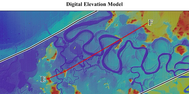
Creating a longitudinal profile of the territory when performing engineering and hydrological surveys for laying a pipeline using a digital terrain model AW3D 2.5 mCompleted work
Work description
1) Order and initial processing of the digital terrain model.
For the implementation of this project, a digital terrain model (DEM) in tiff format was obtained, created based on data from space radar and stereo surveys.
This DEM has passed the procedure of filtering rough outliers of high-altitude terrain objects, and is approximated and smoothed to the true values of the earth's surface heights. The planned and high-altitude coordinates of the project were re-projected, according to the technical specification.
As a result of the data processing steps are derived digital elevation model in a three-dimensional coordinate system with orthogonal elevation, and the maximum and minimum values of the coordinate z, i.e. not only in metric display is exceeded in the survey area, but in visual, when you open it in the software QGis or ArcGis.
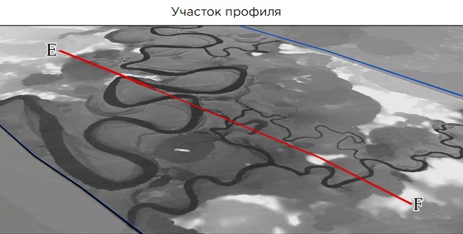
The next stage of processing included the process of creating isolines every 2.5 m. The isolines were not subjected to additional processing in the form of smoothing, but are close to the true forms of the terrain. Then, the data was converted to the dwg format, the resulting materials were monitored, and visualization was performed when the orientation of the project axes changed.
2) The creation of 3 longitudinal profiles of the studied territory was carried out using the ArcGIS software, in which additional constructions were performed to obtain the final product in the form of a longitudinal profile in graphical form. The vectorization of the studied areas on the DEM surface was performed, the excesses and distances of the nodal points were set, and a layout was formed for the design of the longitudinal profile.
3) Design of reporting materials: DEM-in GeoTIFF format, Profiles-in DWG format, graphic materials-in JPEG format, report-in docx format.
Results
The created longitudinal profiles of the territory met the requirements for engineering and hydrological surveys for laying the pipelineNeed for consultation?
Fill the form and we will contact you
Sat-Sun: Non-working days