SAR imagery is a method of remote sensing of the Earth's surface in the microwave range. Radar images provide data day and night, regardless of cloud cover and weather, and reveal surface displacements and objects that are poorly visible on optical images.
Area of interest or coordinates, date or survey period, required spatial resolution, type of radar survey and expected result. If the parameters are unknown, describing the task is enough.
territory boundaries, coordinates, district name or an SHP file
date or time interval of archive or new imagery
required spatial resolution and mono or stereo mode
allowed look angles, cloud cover, sun angle and snow cover
spectral mode, coordinate system, format and composition of the final materials
If the technical parameters are unknown, describing the purpose of the data is enough — specialists will propose a suitable option.
Describe the task in simple words — we will select a suitable solution.
SAR imagery (radar survey) — a special type of space imaging in which the microwave range is used to obtain information — radiation with wavelengths from 1 cm to 1 m — by illuminating the Earth's surface and recording the signal reflected back.
Radar aerial and space imaging is one of the methods of remote sensing of the Earth's surface, allowing images of the terrain to be acquired in the microwave range of the electromagnetic spectrum. Radar images provide views of the Earth's surface and objects on it regardless of weather, day and night, by emitting and receiving probing signals reflected from the Earth's surface, then converting them into images or extracting the phase difference between the transmitted and reflected signal.
Data from radar sensors, like optical satellite images, have various spatial resolutions and can capture information in different electromagnetic bands. Radar satellite data consist of two components — phase and amplitude. Differential interferometric processing of the phase component measures displacements of the reflecting surface, while processing of the amplitude component differentiates the reflecting surface by roughness type and volumetric scattering, i.e. interprets objects.
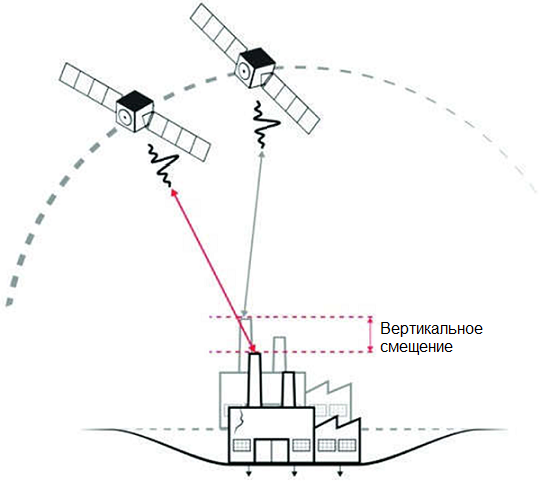
The technology of differential interferometric processing consists in forming an interferogram, which, in simplified terms, is the result of multiplying a pair of complex-valued radar images of the same area acquired by identical SAR systems from nearby orbit points. The difference in phase-cycle values within each pixel of the interferogram is the relative change in distance between the reflector (the probed surface) and the SAR radar antenna.
Principle of differential interferometry
2
Radar imaging is indispensable compared with other observation methods in difficult weather: it can acquire images at any time of day and in any weather, measure coordinates and geometric characteristics of objects with high accuracy, and observe and detect objects invisible in the optical or infrared bands of the electromagnetic spectrum, hidden by snow or vegetation, or located beneath the Earth's surface.
SAR processing is a demanding task because a raw radar image looks unfamiliar to the human eye. Specialised software is used, and specialists must have proper experience in creating secondary products of radar space imagery. Even so, the advantages of SAR make radar imagery highly sought after.
Three degrees of radar data processing can be distinguished:
Single Look Complex (SLC) image — information obtained by focusing the transmitter signal. At this SAR processing level the radar image includes two channels: an amplitude ("panchromatic") grayscale image and a phase image of the signal, used to create digital elevation models and displacement maps of the Earth's surface
Geocoded image. The radar image has a spatial reference in a given coordinate system. Radar images at this SAR processing level are typically delivered in GeoTIFF format.
Orthorectified image. A high-quality radar image without geometric distortions from the terrain. Radar satellite imagery at this SAR processing level is used to create cartographic materials and for spatial analysis.
Use of radar imaging
The tasks of radar imaging expand every year. Innovative SAR processing opens ever newer applications of radar imagery:
Creation and updating of digital topographic maps. The ability of radar imaging to acquire images regardless of weather makes it a real breakthrough for mapping the Russian Far East and other countries where snow hinders surveys in winter and the rainy season brings continuous cloud cover throughout the imaging season. Another advantage of SAR for mapping is the relatively high spatial resolution of radar images, which enables maps to be created and updated up to a scale of 1:50,000.
With phase information from the radar signal, digital elevation and terrain models can be created by interferometric processing. They in turn can be used in many areas of society.
Multi-temporal radar images provide information on displacements of the Earth's surface. This helps detect subsidence at mineral deposits, deviations of infrastructure objects from their normal position and track landslide processes
Radar imaging of water surfaces makes it possible to detect oil spills. Because of the structure of the substance they have a smoothed surface and a different radar reflectivity compared with natural water. This makes an oil spill relatively easy to identify on a radar image.
Radar imaging also makes it possible to find ships whose tracking signal has been switched off deliberately or after an accident. The signal on a radar image is well reflected from metal surfaces and enables ships to be detected automatically even on medium-resolution radar images. It is also important that radar images can be obtained just an hour after acquisition. This timeliness helps the relevant services locate the vessel more accurately.
The varying reflectivity of radar imaging makes it possible to detect burn scars and clear-cuts in forests and to monitor the condition of agricultural crops.
Advantages of SAR (radar imaging)
Ability to perform radar imaging in any weather (including heavy cloud cover) and at any time of day (including night);
High level of detail due to the high spatial resolution of the radar image;
A cost-effective alternative to GPS monitoring of ground displacements.
4
The purpose of space radar imaging is to obtain timely, up-to-date information about the terrain and water surface needed to solve numerous tasks in various fields; the main ones are:
creation and updating of topographic maps and plans, as well as other cartographic products;
creation of engineering-geological maps during geological surveys
land-management and cadastral work;
creation of digital terrain models for planning and development of telecommunication networks;
agricultural research, detection of plant diseases, determination of the vegetation phase;
monitoring of emergencies and their consequences, control of emergency restoration work;
forest inventory (forest accounting, determination of age, height and diameter of growing trees, timber stock, annual increment, etc.);
detection of emergency oil spills;
detection of fuel dumping from ships;
information support for the prevention and elimination of oil and petroleum-product spills;
monitoring of deformation and displacement of the Earth's surface at mineral deposits;
monitoring of structural deformations in cities;
monitoring of critical industrial facilities;
pipeline monitoring;
monitoring of roads and railways and other objects;
monitoring of ice conditions and ship movements;
monitoring of hazardous natural and natural-technogenic processes, including earthquakes, landslides and collapses, avalanches, mudflows, loess subsidence, flooding, karst, suffosion, river erosion, and reworking of sea and reservoir shores.
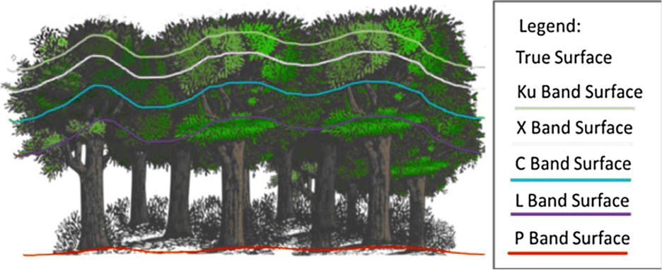
Fig. Depth of forest-canopy penetration by the wave in various radar bands
Advantages of using radar images
Radar imaging has a number of advantages over other observation methods: high accuracy of measuring coordinates and geometric characteristics of objects, and the ability to obtain radar images at any time of day and in any weather (microwave radiation passes freely through clouds and does not require daylight, unlike images in the visible and IR bands).
Ability to perform radar imaging in any weather (including heavy cloud cover) and at any time of day (including night);
High level of detail due to the high spatial resolution of the radar image;
A cost-effective alternative to GPS monitoring of ground displacements.
Innovative processing opens ever newer applications of radar imagery:
The ability of radar imaging to acquire images regardless of weather makes it a real rescue for mapping the Russian Far East and other countries where snow hinders surveys in winter and the rainy season brings continuous cloud cover throughout the imaging season. Another advantage of SAR for mapping is the relatively high spatial resolution of radar images, which enables maps to be created and updated up to a scale of 1:50,000.
With phase information from the radar signal, digital elevation and terrain models can be created by interferometric processing. They in turn can be used in many areas of society.
Multi-temporal radar images provide information on displacements of the Earth's surface. This helps detect subsidence at mineral deposits, deviations of infrastructure objects from their normal position and track landslide processes
Radar imaging of water surfaces makes it possible to detect oil spills. Because of the structure of the substance they have a smoothed surface and a different radar reflectivity compared with natural water. This makes an oil spill relatively easy to identify on a radar image.
Radar imaging also makes it possible to find ships whose tracking signal has been switched off deliberately or after an accident. The signal on a radar image is well reflected from metal surfaces and enables ships to be detected automatically even on medium-resolution radar images. It is also important that radar images can be obtained just an hour after acquisition. This timeliness helps the relevant services locate the vessel more accurately.
The varying reflectivity of radar imaging makes it possible to detect burn scars and clear-cuts in forests and to monitor the condition of agricultural crops.
5
Radar imaging provides radar images in any weather and at any time of day, ensures high measurement accuracy and is used for mapping, interferometry, monitoring of oil spills, ice, ships, forests and agricultural crops.
6
Consultation
free
Preliminary analysis
free
Ordering radar images
from USD 1,000 per scene depending on the survey (archive vs new, resolution) *
Turnaround time
From 5 working days (depends on volume, complexity category, availability of archive imagery)
Frequently asked questions
Answers to key questions about service parameters, timelines, deliverable formats and workflow. If you did not find what you need — contact us and we will help.
Area of interest (location / coordinates of the object in any convenient format, and the area of the object)
Date or time interval for which archival imagery can be searched or new imagery can be acquired
Requirements for the survey (angle of the image, sun angle, resolution, type of survey, cloud cover)
The terms of work execution depend on the area of the territory, requirements to the survey parameters. The minimum period of work execution is from 5 working days
100% prepayment on the invoice for remote sensing materials after signing the contract, the rest of the payment after the work is done.
SAR imagery/SAR Images (Radar satellite data) is quite an arduous task, because a radar image has a raw image that is unfamiliar to the human eye. Specialized software products are used for radar processing, and specialists should have proper experience in creating secondary products of radar space imagery. However, despite this, the advantages of radar make the use of radar imagery very much in demand.
Single Look Complex (SLC) image - information obtained through the focusing of the transmitted signal. The radar image at this processing level includes two channels: an amplitude ("panchromatic") image in grayscale and a phase image of the signal, which is used for creating digital elevation models and displacement maps of the Earth's surface.
Geocoded image - The radar image is spatially referenced in a specific coordinate system. Radar images at this processing level are typically delivered in GeoTIFF format.
Orthorectified image - High-quality radar image without geometric distortions caused by terrain. Radar satellite imagery at this processing level is used for cartographic materials and spatial analysis.
Need satellite imagery or help choosing the right data?
Describe your task, area of interest, and desired outcome. We will check data
availability, assess new acquisition options, and propose the optimal solution in terms of timelines, cost,
and quality.
Мы используем Яндекс.Метрика и собственные Сookies для обеспечения наилучшего
опыта работы на нашем сайте, персонализации сайта для наших пользователей и аналитики.
Продолжая использовать сайт вы соглашаетесь с условиями
Пользовательского соглашения.
Request a call
Leave your contact details — we will get back to you during business hours, clarify the task and suggest suitable data or services.
Write to e-mail
Send a message, technical specification or task description. We will review your request and reply to the specified e-mail.
Fill in the order form
Describe the area, object and imagery requirements. We will check archive availability, the possibility of a new acquisition and offer a suitable option.