Challenges and Prospects, Conclusion, Sites for monitoring the Northern Sea Route
Challenges and Perspectives
Issues of Data Availability, Quality, and Satellite System Resolution
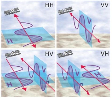
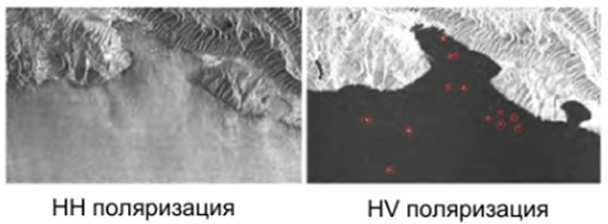
There is a severe lack of data for monitoring the Northern Sea Route and, more broadly, the Arctic and Antarctic zones due to their geographical location and monitoring nature. Not all satellites with Synthetic Aperture Radar (SAR) capture data in the required ranges and polarizations. For example, the ICEYE SAR satellite with the X-band radio wave range specified for ice monitoring has only one polarization, VV, while monitoring ice conditions strictly requires HH with cross-polarization HV.
Earlier, the need for data was adequately met by the Sentinel-1A/B satellites. However, in 2021, communication was lost with Sentinel-1B, and data from this satellite ceased to arrive, significantly affecting the ice cover monitoring process.
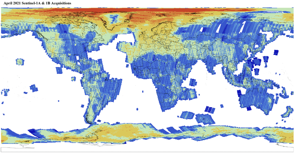

Figure 9. Number of data sets before and after the Sentinel-1B satellite failure. You can observe the decrease in the number of images over the territory of the Russian Federation and the Arctic.
To compensate for the data shortage, plans are underway to launch the third satellite in the Sentinel-1 series, Sentinel-1C, which will be launched as part of the European Copernicus program. The launch was planned on the new ESA Vega-C rocket from the European spaceport in French Guiana in the first half of 2023. However, there is currently no news about the satellite.
Russia's space industry is also advancing. In May 2023, the Condor-FKA satellite was launched (unfortunately, images from this satellite are not yet available for commercial ordering as of 616.11.2023), and in July 2023, the Meteor-M meteorological satellite No. 2-3 was launched. In 2024, multiple satellites are planned to be launched specifically for monitoring the Northern Sea Route, such as Overview-R (X-band with an active phased array antenna (APAA)), Arctica-M No. 2. In 2024, the launch of the Russian radar satellite "Oculus" is planned, marking the beginning of the creation of a Russian orbital satellite group for round-the-clock all-weather monitoring of the Northern Sea Route and the Arctic.
The lack of reliable data on the state of the ice cover on the Northern Sea Route has become a serious problem for many companies involved in maritime logistics and cargo transportation. However, thanks to the development of modern technologies and the use of commercial satellite imagery, the problem is being addressed.
Commercial images obtained through satellite systems allow for more accurate and detailed data on the state of the ice cover on the Northern Sea Route. These images have high quality and cover a large area, making them an invaluable tool for monitoring ice conditions.
Creation of a Unified Digital Platform for NSR Digital Services
The project to create a unified digital platform for digital services of the Northern Sea Route is a state initiative supported by the Government of the Russian Federation. The project is organized by the Ministry of Transport of the Russian Federation.
The project aims to create a unified digital space to ensure the effective operation of the transport and logistics system of the Northern Sea Route, including infrastructure development, improvement of service quality, and better business conditions.
It represents a comprehensive program aimed at modernizing and developing the transport and logistics system of the region. It includes several stages, each with its own features and tasks.
Stage #1 - development and implementation of information systems for monitoring and managing transportation flows on the Northern Sea Route, which will increase the efficiency of port and terminal operations, improve service quality, and reduce cargo delivery time.
Stage #2 - development and implementation of new technologies and innovative solutions to optimize logistics processes, including the use of drones for monitoring the condition of ports and terminals, the development of automatic identification systems for cargo and vehicles, etc.
Stage #3 - improving the comfort and safety of passengers and cargo. The plan includes the development and implementation of online ticket booking and cargo transportation services, monitoring and control systems for vessel conditions, and other services to make the transportation process more convenient and safe.
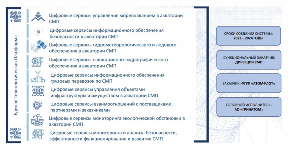
Figure 10. Architecture and subsystems of the unified digital platform for digital systems
The project's tasks include:
- Creation of a unified information system for monitoring and managing transportation flows on the Northern Sea Route;
- Development and implementation of new technologies and innovative solutions to optimize logistics processes;
- Development of electronic services to ensure the comfort and safety of passengers and cargo;
- Improving the efficiency of resource utilization and reducing transportation costs.
The project plans to create a unified digital platform that will bring together various services and information resources related to the operation of the Northern Sea Route. This may include online services for booking tickets and transporting cargo, monitoring and control systems for vessel movement, databases on the condition of ports and terminals, and other services aimed at simplifying and accelerating the cargo transportation process.
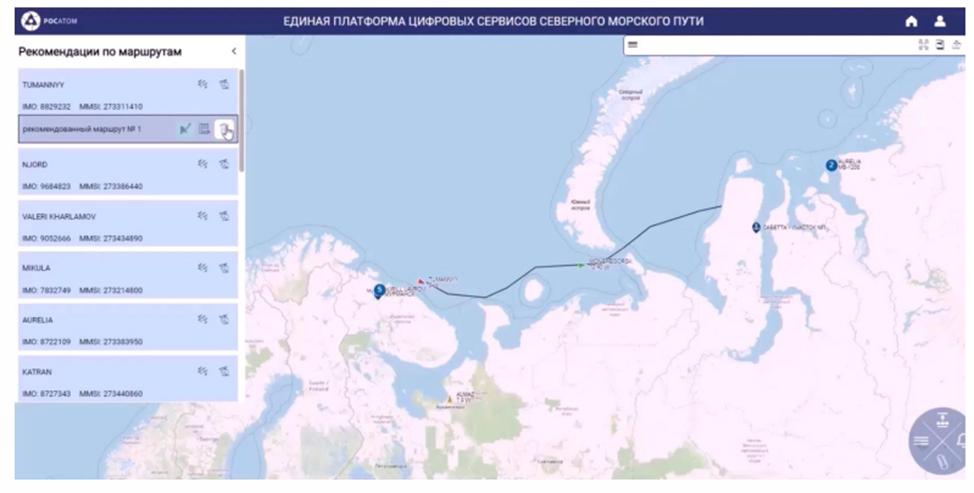
Figure 11. Platform Prototype
Conclusion
Monitoring the Northern Sea Route is an integral part of a modern and comprehensive approach to studying and ensuring safety in the Arctic. This article placed special emphasis on the radar method of ice research, which, with the help of satellite systems, provides reliable and accurate information about the condition and movement of sea ice.
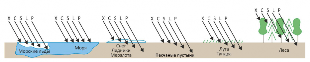
The technical specifications of satellites used for monitoring the Northern Sea Route play a key role in data collection and analysis. For ice and vessel monitoring, HH and HV polarizations are necessary. Satellites such as IceyeSAR or HiSea-1 are not suitable for monitoring the Northern Sea Route and the Arctic because they have only one VV polarization. Regarding the radio frequency range, there are no such strict requirements; with the mandatory polarization, any radio frequency range allows obtaining the necessary data for ice monitoring.
Satellites such as Sentinel-1, Radarsat-1/2, TerraSAR-X, TanDEM-X, ALOS PALSAR, ERS-1, ERS-2, ENVISAT, COSMO-SkyMed 1–4 (if using medium-resolution mode with dual polarization HH/HV), etc., have stood the test of time and proven themselves well in Arctic ice research.
Satellites such as Gaofen-3 (C-band) and KOMPSAT-5 (X-band) are also suitable for monitoring Arctic ice, although they have not been widely used in research.
However, it is essential to note that monitoring the Northern Sea Route is not limited to the radar method of ice research alone. The creation of a digital ecosystem for the sea route, bringing together data from various sources, allows for a more complete and comprehensive picture of the situation. New satellites expected in the near future open up new possibilities for improving monitoring and supporting safe navigation in this region.
Thus, upcoming satellite launches and the development of the digital ecosystem of the sea route will make monitoring the Northern Sea Route even more reliable, efficient, and essential for risk prevention and sustainable development in the Arctic.
Our company, LLC "GEO Innovations," has been supplying and processing radar and optical satellite images since 2020. As of November 2023, we confirm our ability to provide satellite monitoring services in the Arctic zone, including the Northern Sea Route.
Websites for Monitoring the Northern Sea Route:
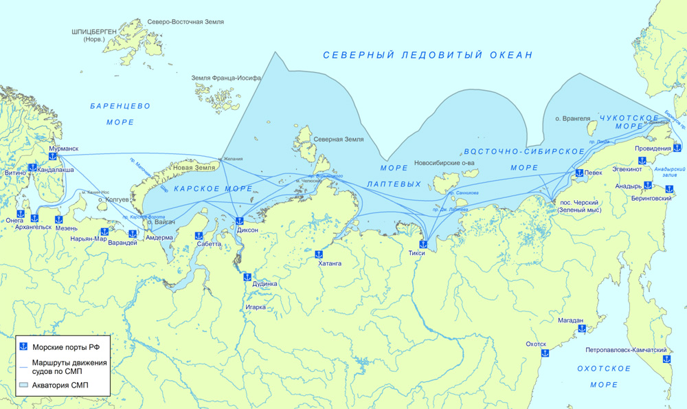
GlavSevMorPut - the main website for monitoring the NSR in Russia. Provides current ice maps for the Kara Sea, Laptev Sea, East Siberian Sea, Chukotka Sea. Also, you can find synoptic forecasts and hydrometeorological information for the desired date.
Hydrometcenter of Russia - provides fresh data on the current state of sea ice for the required sea. Also, there is information on the cohesion of sea ice in the Arctic and Antarctica.
PolarView – a service developed by an international consortium of experts, providing a wide range of products for Earth observation (data from Sentinel-1, Radarsar-2, etc.), monitoring polar regions, and areas subject to ice and snow.
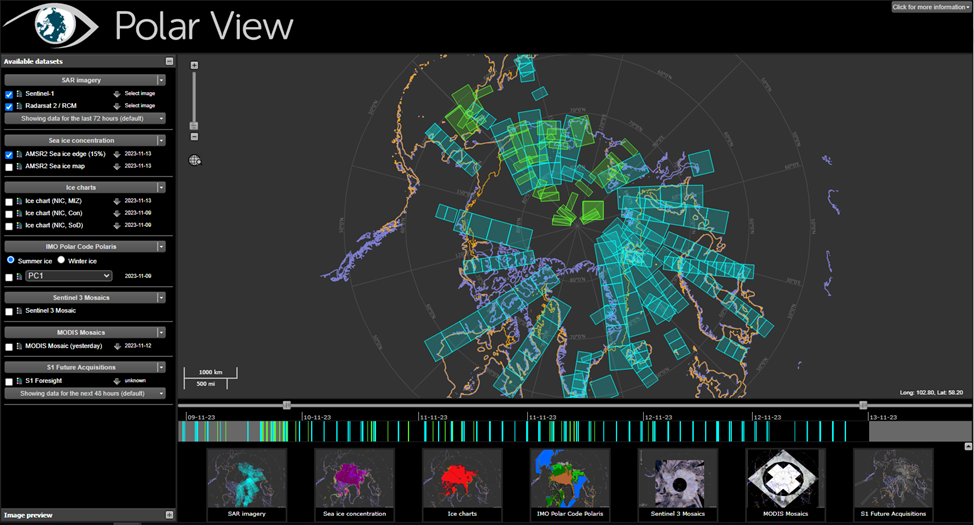
Figure 12. PolarView Interface
National Snow and Ice Data Center at the University of Colorado - an information and reference center in the USA supporting polar and cryospheric research. NSIDC archives and distributes digital and analog snow and ice data and keeps information about snow and ice cover. Provides daily information on the state of the Arctic and Antarctic ice.
Norwegian Meteorological Institute's Ice Monitoring Service - this web portal provides access to current products and information on sea ice, snow, and permafrost (cryosphere) from the Norwegian Meteorological Institute. Provides current ice maps not only for the NSR and Arctic seas but also for nearby seas, bays, and fjords. In addition, it provides mosaics of satellite images from Sentinel-1 and Radarsat-2.
Official Government of Canada website with current information on Arctic ice conditions - the map collects the most recent ice information available on the maps of the Canadian Ice Service. This ice information is updated daily in areas of known maritime activity.
The special opinion of the CEO
Natalia N. Malkova:
"There is a widely spread hypothesis about the dynamics of ice melting in the Arctic zone, which brings prospects for the development of navigation along the Northern Sea Route as an alternative to the route from Asia to Europe through the Suez Canal. So, this hypothesis is not an axiom. Analysis of the results of space monitoring of the ice situation in the Arctic does not lead to the conclusion of a guaranteed annual increase in the navigation period of non-ice-class vessels.
What is guaranteed is the militarization of the Arctic region. The NATO Arctic doctrine is approved, in the USA, in January 2021, the doctrine "Regaining Arctic Dominance" was adopted.
"When Finland and Sweden join NATO, seven out of eight Arctic countries will be NATO members" - NATO Secretary-General Jens Stoltenberg on August 26, 2022.
As of October 20, 2023, competitive pressure from the NATO military bloc for control over the Arctic waters is increasing.
In opposition to this pressure, including to reduce the risk of conflict, Russia in the Arctic is increasingly involving China.
In conditions of growing military tension, the constant ecological monitoring of the fragile nature of the Arctic zone becomes of increasing importance for which Russia, by all means, needs to have its satellite group."



 .
.