of geospatial solutions
Sat-Sun: Non-working days
When developing urban development plans, project leaders and municipal workers need as deep and comprehensive an understanding of the territory as possible, even at the earliest stages of work. Such understanding must be continuously and comprehensively supplemented and refined to maintain relevance, objectivity, and alignment with standards that are uniform across all project stakeholders.
In urban development guidelines issued by several local authorities in Italy, the use of remote sensing data is recommended as an important source of standardized, regularly updated information.
Following this approach, Planetek Italia s.r.l. developed the "off-the-shelf" product Preciso® Land, combining very high-resolution VHR (Very High Resolution) satellite imagery from WorldView-2 with traditional cartographic data. The goal was to create a geoinformation product that allows for standardized procedures to extract decision-making data about the environment.
The methodology employs a semi-automatic method for delineating primary land use classes and generating a soil sealing layer from WorldView-2 spectral zone images. The result is a uniform distribution of information with a resolution of 2 meters over the test area. It is crucial to note that all eight spectral zones provide automatic identification of soil sealing, thanks to the unmatched informational content provided by the WorldView-2 satellite.
The outcome was a "multilayered" product combining exceptionally high geometric accuracy with a high level of alignment with existing cartographic information.
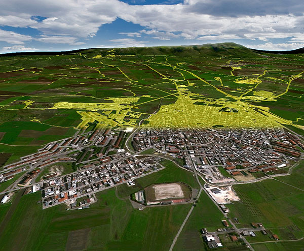
Fig. 1. Soil degradation data obtained by semi-automatic processing of WV-2 spectral zone data in the municipal model.
Implemented in the product, the methodology involves semi-automatic extraction of primary land use classes and the creation of a soil degradation layer from WorldView-2 spectral data. This approach results in a homogeneous distribution of information with a resolution of 2 meters across the designated area. It's important to highlight that this automated detection of soil degradation utilizes all eight channels - an unmatched capability of WorldView-2.
The result (Fig. 1) serves not only as foundational information for determining urban land density maps but also as a promising source of an important indicator: the Soil Loss Index. This index aids decision-making by providing insights into current conditions and assessing the impact of proposed programs on sustainable development. Semi-automatic creation of the soil degradation layer from WorldView-2 spectral data is significantly accelerated when retrospective sequences of WV-2 images are available.
Furthermore, automating the processing of high-resolution WorldView-2 multispectral datasets significantly reduces processing time while ensuring high levels of accuracy and documentation.
Thanks to this approach, project leaders and municipal planners can use geoinformation products based on VHR satellite imagery to provide informationally complete, temporally relevant, and detailed insights. These products can be regularly updated and, due to their high level of standardization, enable analysis of process dynamics over time, forming the basis for defining geospatial indicators.
Sat-Sun: Non-working days