Why remote sensing data is an investment rather than an expense
Three Key EO Use Cases for Subsoil Users
Scenario 1. Preventive Audit of a Licensed Area
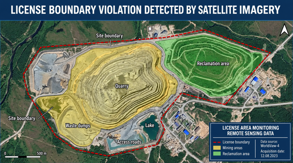
Example: overlaying the boundaries of a licensed area on up-to-date satellite imagery can reveal mining operations extending beyond the permitted zone before this is detected by an inspector.
Objective: to ensure that actual operations comply with the license terms and the approved technical project before an inspection by regulatory authorities.
High-resolution satellite imagery (0.5–2 m/pixel) makes it possible to determine with sub-meter accuracy:
● the boundaries of open-pit workings and compare them with licensed coordinates;
● the location of overburden dumps;
● the presence and condition of reclaimed areas;
● the condition of infrastructure facilities (roads, pipelines, industrial sites).
● Client benefit: timely detection of deviations, the ability to remedy violations before an inspection, and avoidance of fines of up to RUB 1 million.
Scenario 2. Regular Monitoring of an Oil & Gas or Coal Field
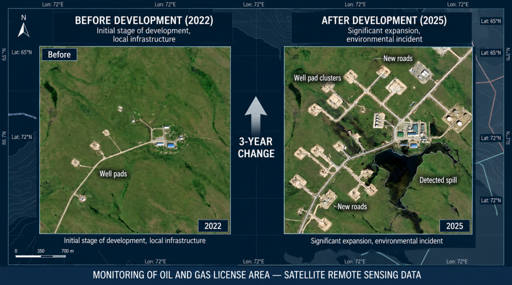
Comparison of imagery acquired at different times makes it possible to track the expansion of well pads, infrastructure development, and the environmental condition of the area.
Objective: to monitor changes in economic activity within an active licensed area throughout the entire license term.
Regular acquisition of imagery on a quarterly or monthly basis enables systematic assessment of site conditions and provides an objective evidence base demonstrating responsible subsoil use in communications with regulatory authorities.
Applications in the oil and gas industry:
● mapping of field development facilities;
● detection of petroleum product spills;
● monitoring the condition of pipeline protection zones;
● updating road networks and planning logistics;
● assessment of changes in shorelines and wetlands.
Client benefit: a documented history of compliance with license conditions, reduced regulatory risks, and an information base to support license renewal.
Scenario 3. Reclamation Monitoring and Preparation for License Closure
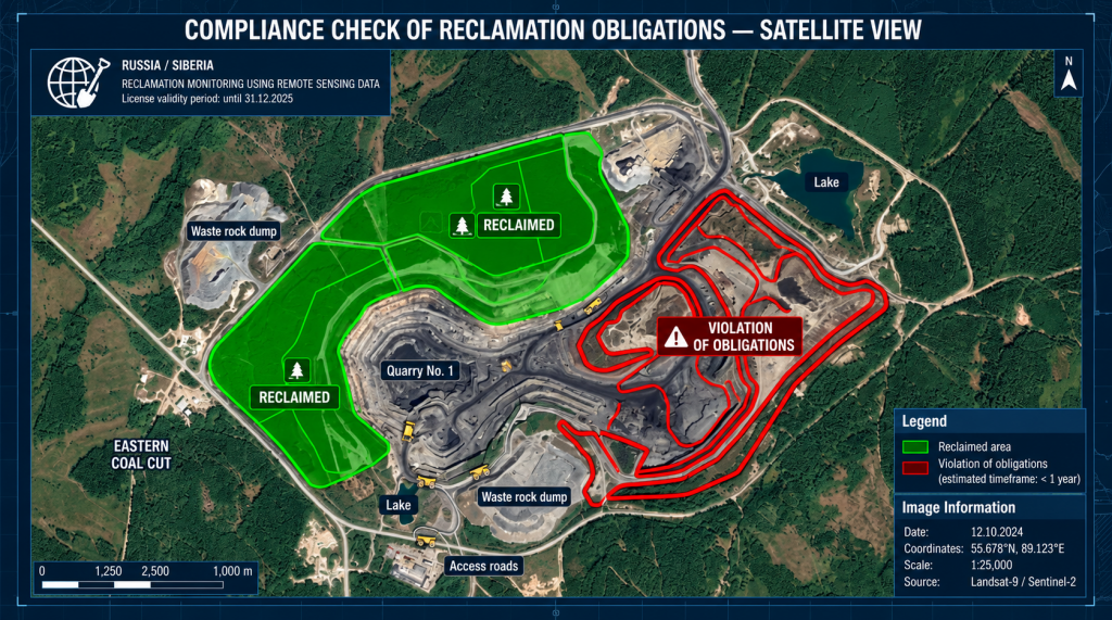
Objective: to confirm fulfillment of obligations to reclaim disturbed land as a mandatory condition for license renewal or closure.
Reclamation of subsoil areas granted for use is a mandatory condition for license renewal. In 2025, 44% of the inspected sites had their licenses revoked specifically due to failure to comply with this requirement.
Multispectral imagery makes it possible to monitor the condition and recovery dynamics of vegetation cover and assess the quality of reclamation activities.
EO data for reclamation monitoring:
● NDVI analysis to assess vegetation condition and recovery;
● detection of contaminated areas;
● long-term monitoring of vegetation establishment and survival;
● creation of a photographic evidence base for formal handover of the site to the regulator.
Client benefit: confirmation of compliance with license obligations, minimization of the risk of license revocation, and reduced exposure to environmental claims.
Forest Management within a Licensed Area: Requirements of Clause 63 of the Forest Management Instruction
Most licensed subsoil areas in Russia are located within forest fund lands. Under Article 72 of the Forest Code of the Russian Federation, subsoil users are required, at their own expense, to carry out forest inventory and design measures for forest conservation within the forest area granted to them.
This means that the license holder becomes the customer for forest management works, and the EO materials used for these purposes must comply with specific regulatory requirements.
Clause 63 of the Forest Management Instruction (Order No. 510 of the Ministry of Natural Resources and Environment of the Russian Federation dated 05.08.2022, effective until 01.03.2029)
Clause 63 establishes minimum spatial resolution requirements for EO materials depending on the type of forest management activity:
|
Forest Management Activity
|
Required EO Spatial Resolution
|
|
Forest district planning
|
no worse than 2.5 m/pixel
|
|
Planning of production, protective, reserve forests and specially protected forest areas
|
no worse than 2.5 m/pixel
|
|
Forest inventory: visual-instrumental and visual assessment methods
|
no worse than 2.5 m/pixel
|
|
Forest inventory: analytical-instrumental interpretation, automated processing, and rational combinations of methods
|
no worse than 1 m/pixel
|
|
Planning of forest conservation measures
|
no worse than 2.5 m/pixel
|
In addition, Clause 62 establishes a requirement for the georeferencing accuracy of EO materials relative to ground control points: no worse than ±5 meters.
Practical Implications for Subsoil Users
To fulfill mandatory forest management obligations within a leased forest area, a subsoil user may independently procure and use satellite imagery, provided that its technical characteristics comply with Clause 63 of the Instruction. This makes it possible to combine two mandatory processes:
1. Forest management (forest inventory and planning of forest conservation measures) — imagery with a spatial resolution of ≤ 1 m/pixel is required for analytical-instrumental interpretation;
2. Monitoring compliance with subsoil use license conditions — up-to-date high-resolution imagery covering the licensed area is required.
A single, properly selected and technically accurate georeferenced satellite image can satisfy both requirements at the same time.