Modern Earth observation satellites are increasingly driving the development of multifunctional platforms. Instead of launching separate spacecraft for different purposes, engineers are integrating optical sensors, radars, lidars, telecommunications equipment, and specialized payloads either on a single platform or within a distributed system. This makes it possible to obtain more complete and timely information.
Analysis of currently available data shows two main approaches to such integration: the development of single satellites carrying several types of payloads, and the creation of distributed constellations (“virtual constellations”), in which satellites equipped with different sensors operate in coordination. Synchronized imaging creates a new level of data quality and improves the depth of analytical conclusions, while direct data transmission from the spacecraft to the customer can reduce response time by a factor of 100.
There is nothing unusual about military agencies being the first to pursue this direction. Civilian applications also gain significant advantages, particularly in emergency response to technological and natural disasters.
Real Projects and Concepts
Today, several examples of this concept are already being implemented:
 GalaxEye (India). This startup announced the successful testing of the GLX-SQ payload, which, for the first time in the world, combined a synthetic aperture radar (SAR) and an optical camera on a single platform. This makes it possible to obtain imagery that combines the detail of optical data with the all-weather capabilities of radar. As part of the “Drishti” mission, the GalaxEye spacecraft was successfully launched into orbit on May 3, 2026.
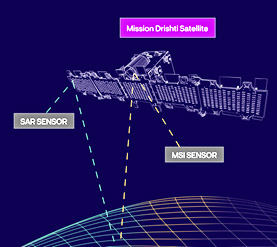
Cooperation between leading global companies is helping advance this concept. Antaris, a provider of software platforms for the space industry, and GalaxEye, a satellite imaging operator, signed a Memorandum of Understanding to develop the world’s first satellite of this kind. The memorandum covers cooperation between three leading Indian space companies — GalaxEye, Ananth Technologies, and XDLINX Labs — and U.S.-based satellite software provider Antaris.
According to the developers, ISRO, and the Indian military, the “Drishti” spacecraft will make it possible to use space-based and ground-based resources as efficiently as possible and stay ahead of emerging threats. The military is particularly interested because Full Mission Virtualization ™ technology (synchronized fusion of optical and radar imagery) allows users to obtain answers to critical questions in near real time, plan dynamic operations in complex security environments, and conduct training and war-gaming exercises in a fully digital environment.
In the development of the spacecraft, Antaris’ digital-first approach makes it possible to design, test, and “execute” the entire mission in a virtual environment, seamlessly integrating every payload and analytical component in order to stay within budget, meet schedules, and remain ahead of events. The result is an integrated hardware and software system designed to operate in “perfect” harmony.

The product used for this “virtual environment” is Antaris SatOS — an open cloud operating system for satellites of any purpose. Designed for interoperability, SatOS™ standardizes satellite operations across different platforms and constellations. Its modular architecture supports rapid integration of equipment from different manufacturers, significantly reducing complexity and cost while improving scalability.
The hardware is integrated on a single payload platform: a thermally stable optical bench carrying both an X-band SAR sensor and a 7-band multispectral imager. This physical arrangement is also an important engineering solution for eliminating parallax errors at the image source and during data fusion. Fusion algorithms also use artificial intelligence for subpixel co-registration and jitter correction. These algorithms ensure that every individual data point from both sensors is captured and processed as part of a single unified dataset.
The optical layer provides intuitive visual context, color, and texture, making image interpretation easier. Typical limitations of optical imaging — darkness, clouds, smoke, and similar conditions — are mitigated in the final product by adding the SAR layer. SAR naturally penetrates clouds, darkness, and smoke, while revealing structural information, surface texture, and elevation-related changes.
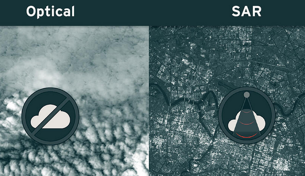
SyncFused™ software for DRISHTI spacecraft image fusion combines the clarity of optical imagery with the all-weather reliability of SAR. The result is a single dataset providing complete context and highly reliable information about ground conditions from a single spacecraft pass.
Azalea (BAE Systems, United Kingdom). This is not a single satellite, but a cluster of four spacecraft flying in formation and operating as one integrated system. Three satellites carry radio-frequency monitoring sensors (RF) for detecting and geolocating signals (SIGINT), while the fourth is equipped with a SAR system supplied by the Finnish company ICEYE for high-resolution imaging. This is an example of a distributed system in which each satellite performs a specialized function, while data over a designated area are concentrated into a common operational picture.
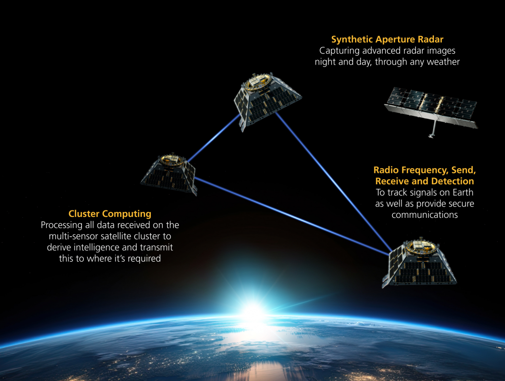
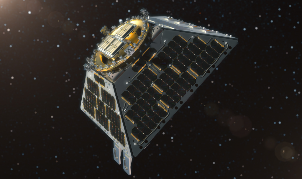
In more detail, Azalea™ is a program to deploy a multifunctional satellite system with radio-frequency capabilities in low Earth orbit. The system will collect a broad range of data and analyze them in orbit using onboard machine learning to deliver intelligence where it is needed.
According to the UK Ministry of Defence, the capabilities provided by Azalea will enable the deployment of advanced intelligence, surveillance, and reconnaissance (ISR) functionality, improving the ability to understand threats and hazards in space, from space, and through space.
Azalea™ spacecraft will simultaneously collect data from multiple sources, including broadband radio-frequency data and synthetic aperture radar (SAR) imagery enabled by technology provided by Finnish company ICEYE, focused on selected targets. The system will provide imaging data day and night and through cloud cover, while cloud-based services will deliver enhanced information and analytics to military, civilian, and commercial users for decision-making. This monitoring capability will simplify the detection of physical changes, such as ship or aircraft movements, as well as locating people at risk during natural disasters such as floods and wildfires.
Compared with existing space-based sensors and traditional data-delivery processes, the Azalea™ system will save valuable time by combining and analyzing data in space. It will identify activities of interest and communicate directly with users on Earth, rapidly and securely delivering reliable information directly to decision-makers.
Unlike conventional narrow-purpose satellites, the cluster will be reconfigurable in orbit in a way similar to installing a new application on a smartphone. This will enable future customer missions and extend satellite service life. Thanks to its open architecture, future Azalea™ clusters will be compatible with different sensor types — including electro-optical, hyperspectral, and infrared systems — as well as allied national programs.
ISR Constellation (Netherlands). This Dutch defense-industry project is aimed at creating a constellation of small satellites for intelligence and surveillance. The concept involves the use of SAR radars, electronic support measures (ESM) sensors, and advanced optical communication links for rapid data transfer between satellites and to Earth.
The objective of the project is to develop an intelligence, surveillance, and reconnaissance (ISR) mission based on SmallSats, combining the advantages of multiple sensors with synthetic aperture radar as the primary all-weather sensor, electronic support measures (ESM), and advanced high-speed optical communication and image-processing technologies. Such a constellation would provide broad ISR capabilities exceeding those of existing space systems, with unprecedented delivery speed and responsiveness.
Advanced research is focused on linking ultra-fast inter-satellite communications with a new synchronization approach based on optical data links, enabling high responsiveness in intelligence, surveillance, and reconnaissance missions and significantly advancing space-based observation and reconnaissance technologies.
The innovative field of image-processing technologies covers the entire image-processing chain. This core technology is critical for innovation in fields including healthcare, semiconductors, security, agriculture, industry, transport, and aerospace.
The project is being implemented by a Dutch consortium consisting of TNO, Nederlands Lucht- en Ruimtevaartcentrum (NLR), and FSO Instruments.

TNO is a major Dutch research organization developing advanced optical and radar instruments for satellites, with expertise in laser communications, Earth observation, and space astronomy.
More broadly, the consortium is participating in the European REACTS project (Responsive European Architecture for Space). Multifunctional spacecraft form part of this initiative.
The REACTS project is intended to lay the foundation for European member states to develop a new, shared, and advanced space-based defense system: a robust network of responsive space systems (RSS) offering full flexibility and scalability. This network is intended to support the launch of multifunctional satellites and the delivery of geospatial data within 72 hours. The project will define the architecture, develop a concept of operations (CONOPS), and establish a roadmap covering both technical and management aspects. In addition, the project will analyze and define RSS interface standards and develop software to model system responsiveness.

The key issue is interoperability among all spacecraft in orbit: “a single shutter click of a coordinated image.”
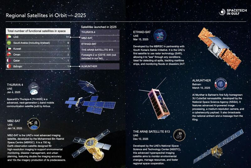
ArabiaEye (Saudi Arabia). A planned constellation of 16 small satellites operating in pairs: one satellite in each pair carries an optical camera, while the other carries a SAR radar. This makes it possible to achieve daily data refresh rates and efficiently combine the resulting datasets through data fusion, for example for civilian applications such as oil-spill detection.

Developed by Airbus Defence and Space and Thales Alenia Space, the spacecraft are also expected to be used for military applications by Saudi Arabia and its partners in the Middle East, as well as for mapping and environmental monitoring.
One SAR spacecraft option within this project, SARsatX, provides, according to officials of the King Abdulaziz City for Science and Technology — a leading organization within Saudi Arabia’s national space program — reliable radar-based Earth observation solutions supporting monitoring, risk management, and informed decision-making in key sectors in coordination with optical spacecraft.
“These initiatives are intended to support the development of a sustainable, high-technology, and self-sufficient space sector under the national VISION 2030 program, covering all regional spacecraft currently in orbit as well as the industry’s future development priorities.”
The telecommunications component of the hybrid network is being developed by Thales Alenia Space and will become part of the
global Omnispace network.