of geospatial solutions
Sat-Sun: Non-working days
Ultra-high spatial resolution is considered to be a pixel size range on the ground from 0.3 m to 1 m. The era of ultra-high spatial resolution began in 1999 with the launch of the Ikonos satellite (GeoEye company), which allowed images with a resolution of 1 m. This was an undeniable breakthrough in the industry, and other companies had no choice but to start developing satellites with similar or better capabilities.
It took less than two years for DigitalGlobe (now Maxar Technologies) to launch the QuickBird satellite with a spatial resolution of 0.61 m. Due to fierce competition in the remote sensing market, we now have access to data with a resolution of 0.31 m, provided by the WorldView-3 satellite. Before the introduction of WorldView-3, 1:5000 scale topographic maps were updated using aerial photography data. However, conducting aerial photography requires obtaining flight permits from the General Staff of the Armed Forces of the Russian Federation and the Federal Security Service of Russia, which can take months. To acquire satellite data, it is enough to contact Innoter. Satellite imagery with a resolution of 0.31 m is almost three times cheaper than data with the same resolution obtained by aerial photography. Data obtained from satellites is also easier to process and analyze due to the larger scene size, the absence of flight distortions, the presence of RPC coefficients, and more.

Fig. 1 Image from the WorldView-3 satellite. Barcelona, Spain
Today, the Chinese segment of the remote sensing market should not be overlooked. In recent years, China has become an undisputed leader in the development of space technology overall and in the number of successful remote sensing satellite launches. The array of ultra-high resolution satellites is constantly expanding and already rivals satellites from unfriendly countries. In the near future, satellite imagery from Chinese satellites may completely displace Western imaging systems from the market.


Spacecraft TripleSAT 1-4
The Chinese constellation of spacecraft was launched into orbit by 21AT in 2015 (satellites 1–3) and 2019 (4th satellite). They were developed in the UK by Surrey Satellite Technology Ltd. A distinctive feature is that they are on the same orbit 4 seconds apart and can capture the same area with a small time difference. Additionally, this constellation can make four passes in different directions along the same line with slight deviation angles. The satellite is equipped with a camera that allows capturing images with a resolution of 0.8 m in the panchromatic channel and 3.6 m in the multispectral (RGB+Nir) channel. Another distinctive feature is their low cost while maintaining high-quality imaging. After initial processing, TripleSAT data can achieve ground accuracy of no less than 5 m, with a cost of $6 per square km. The presence of four active satellites allows for capturing an area several thousand kilometers wide in no more than 14 days.

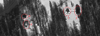
Fig. 2 Image from the TripleSAT satellite. Amsterdam, Netherlands
Spacecraft SuperView-1
SuperView-1 is a Chinese high-resolution Earth observation satellite constellation for civilian use. The operator and data provider is the Chinese company Beijing Space View Technology Co., Ltd. The first two satellites were launched in 2016, the next two in 2018, and the remaining 12 will be launched by 2022. The satellites are equipped with multispectral cameras operating in five bands (Pan, RGB, Nir). Over three years of operation, the satellites have shown good performance in data acquisition speed, data refresh rate, and image quality. With a spatial resolution of 0.5 m, the operator offers ground accuracy up to 3 m after initial processing.

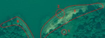
Fig. 3 Image from the SuperView-1 satellite. Venice, Italy
Spacecraft SuperView-NEO (China)
In recent years, China has been a clear leader in the number of successful Earth observation satellite launches. Launched in April 2022, the Chinese SuperView NEO satellite has a spatial resolution of 0.3 m and can compete with the best American Earth observation satellites. The NEO constellation consists of two satellites, allowing for repeated imaging of the same area with a two-day frequency. Compared to previous SuperView-1 satellites, the SuperView NEO 1-01/02 satellites have an increased aperture optical system, and CMOS matrices are used for image recording instead of traditional CCD matrices with temporal accumulation. The satellites are highly maneuverable, allowing for three-dimensional imaging from a single pass by sequentially capturing images with forward, backward, and nadir tilts, performing area imaging by stitching five parallel strips, conducting route imaging, and capturing up to 20 different targets. Despite these enormous capabilities, the constellation's imaging cost is about $20 per square km, which is almost twice cheaper than ordering images from Western satellites with similar resolution.

Fig. 4 Image from the SuperView NEO-2 satellite. Dubai, UAE.
Spacecraft Jilin-1KF01A/B/C (China)
On January 15, 2020, the Jilin-1KF01A satellite was successfully launched at the Taiyuan Satellite Launch Center in China. The Jilin-1KF01A is a new high-performance optical remote sensing satellite independently developed by the company. The satellite inherits the mature single-machine and technical foundation of the Jilin-1 satellite. For the first time, it uses a large-aperture, wide-field-of-view, long-focus-axis design with three optical transmission systems. The satellite can capture images in panchromatic mode with a resolution of 0.75 m and in multispectral mode with a resolution of 3 m, with a swath width of over 136 km. It is the largest sub-meter optical remote sensing satellite with high resolution and ultra-wide amplitude. The satellite has large, high-speed memory, high-speed data transmission, and several other advantages.

Fig. 5 Image from the JL-1KF01A satellite. Clermont-Ferrand, France.
Another satellite in the Jilin-1KF01B constellation was launched on July 3, 2021. The Jilin-1KF01B inherits the technologies of its predecessor, the Jilin-1KF01A. The satellite's swath width is over 150 km, and it can capture over 2 million square kilometers of high-resolution images. This series of satellites uses several innovative technologies, such as lightweight construction, high-tech electronic systems, and high-resolution cameras, made of ultra-light and low-cost materials. For this reason, the satellite weighs only 40 kg, but the spatial resolution of its images is 0.5 m.

Fig. 6 Image from the Jilin-1KF01B satellite, China.
The Jilin-1KF01C satellite was launched into orbit on May 5, 2022. The Jilin-1KF01C is a remote sensing satellite developed and manufactured by Chang Guang Satellite Technology Co., Ltd., designed to capture panchromatic and multispectral images of the Earth with ultra-high spatial resolution and a wide swath width. The KF-01C fully inherits the ideology and scheme of the KF-01B satellite. It can capture up to 2 million square kilometers per day, and when operating from a standard height of 539 km, the swath width is at least 150 km, with a resolution of 0.50 m in the panchromatic range and 2.00 m in four multispectral channels. The information transmission channel has a bandwidth of up to 3 Gbps.

Fig. 7 Image from the Jilin-1KF01C satellite. Bolkhov, Russia.
You can order from us


Sat-Sun: Non-working days